
Image: Song Dynasty Map

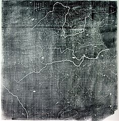
Description: The Chinese Yu Ji Tu (Map of the Tracks of Yu the Great), a map carved into stone in the year 1137 during the Song Dynasty, located in the Stele Forest of modern-day Xian, China. Yu the Great refers to the Chinese deity described in the Chinese geographical work of the Yu Gong, a chapter of the Classic of History. Needham and Chavannes assert that the original map must have predated the 12th century. The graduated scale of this gridded map is at 100 li (Chinese mile) squared for every representative square in the grid. The overall size of the map is 3 ft squared. The coastal outline is relatively firm and the precision of the network of river systems is incredibly accurate. The name of the geographers and cartographers who initially created the map are unknown. In the year 1142 a copy of the map was preserved at Zhenjiang in Jiangsu province by a certain Yu Chi, who was then a Prefectural Director of Studies. There is also mention of an earlier copy of about 1100 AD which itself was based on the Chang'an version. Needham asserts that the map was used primarily to instruct students while referring to sites described in the ancient Yu Gong chapter of the Classic of History.
Title: Song Dynasty Map
Credit: Joseph Needham's Science and Technology in China, Vol. 3: Mathematics and the Sciences of the Heavens and the Earth, Plate LXXXI and text description pp. 547–549, hardback edition
Author: Unknown, photo by PericlesofAthens
Usage Terms: Public domain
License: Public domain
Attribution Required?: No
Image usage
The following page links to this image:
