History of geography facts for kids
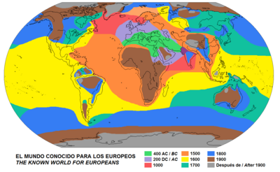
The history of geography is all about how people have understood and described our Earth over time. The word 'geography' comes from Greek words meaning "Earth-writing." The first person to use this word was Eratosthenes around 200 BC. But even before that, people were already doing things like making maps!
Contents
Ancient Civilizations
Egypt
For the ancient Egyptians, the Nile River was the center of their world. They saw their world as built around this important river. They knew about different oases to the east and west, which they thought were home to various gods. To the south, they knew about the Kingdom of Kush, and further south along the Red Sea was a region called Land of Punt. They also knew about different groups of people in Asia, like the Hittites. The Mediterranean Sea was called "the Great Green." They believed it was part of a huge ocean that went all around the world.
Babylon
The oldest known world maps come from ancient Babylon, dating back to the 9th century BC. The most famous Babylonian map is the Imago Mundi from about 600 BC. This map shows Babylon on the Euphrates River, surrounded by a circular landmass. This landmass included places like Assyria and other cities. Around this land was a "bitter river," which was their name for the Oceanus (a world-encircling ocean). The map also showed seven islands in this ocean.
Greco-Roman World
The ancient Greeks believed Homer was the first geographer. His famous stories, the Iliad and the Odyssey, have lots of geographical details. Homer described a circular world surrounded by a giant ocean. By the 8th century BC, Greeks knew a lot about the eastern Mediterranean.
Thales was one of the first thinkers to wonder about the Earth's shape. He thought the world was based on water. His student, Anaximander, was the first to try making a map of the known world to scale.
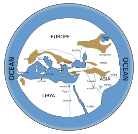
Hecataeus of Miletus created a different kind of geography. He gathered information from older works and talked to sailors. From these stories, he wrote a detailed description of the world. Another similar work is Herodotus' Histories. This book is mainly about history, but it also has many geographical descriptions. It covers places like Egypt, Persia, and even mentions India. Herodotus also noticed how large rivers, like the Nile, create deltas (triangle-shaped land at river mouths). He was also the first to observe that winds usually blow from colder places to warmer ones.
Pythagoras was probably the first to suggest that the Earth was a sphere (a perfect ball). Plato liked this idea, and Aristotle found proof. He noticed that the Earth's shadow during a lunar eclipse is always curved. He also saw that stars appear higher in the sky as you travel north. This led Greeks to believe the world had five climate zones: two very cold zones at the poles, two very hot zones near the equator, and two mild zones in between, where people could live.
Hellenistic Period
Explorers like Hanno the Navigator traveled far south in Africa. The Egyptian Pharaoh Necho II even sent Phoenician sailors to sail all the way around Africa. When they sailed west around the southern tip of Africa, they noticed the sun was on their right (to the north). This helped people realize the Earth was round.
In the 4th century BC, the Greek explorer Pytheas traveled through northern Europe and around the British Isles. His discoveries were often doubted because the regions he found were more livable than people expected. Great conquerors like Alexander the Great also explored. He took geographers with his army to record their observations as they moved east.
The ancient Greeks divided the world into three continents: Europe, Asia, and Libya (Africa). They thought these continents were surrounded by an ocean. They believed the far northern and southern parts of the world were too extreme for people to live in.
The size of the Earth was a big question. Eratosthenes calculated the Earth's circumference very accurately. This made people wonder what was in the huge unknown areas of the world.
Roman Period
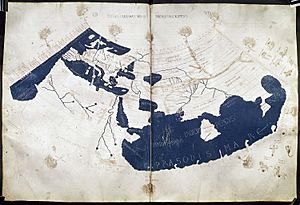
Many works by early geographers are lost, but we know about them through Strabo (64 BC – 24 AD). His 17-volume geography book is almost completely preserved. It's a key source of information about classical geography. A century later, Ptolemy (90 – 168 AD) created his Geographia. By this time, the Roman Empire had grown, and new areas like the British Isles were explored. The Silk Road also brought knowledge of the Far East. Ptolemy listed many cities, tribes, and places, putting them on a map of the known world.
The Romans used geography and maps a lot in practical ways. Their huge road system, which was about 55,000 miles long, needed careful planning using geographical measurements. Roman surveyors gathered information about the land to find the straightest routes for roads. They used tools like sun dials and theodolites (for measuring angles).
Around 400 AD, a map called the Peutinger Table was made. It showed the Roman road network across the known world. This map included the Roman Empire, India, Sri Lanka, and China. It was about 1.12 feet high and 22.15 feet long. The tools and ideas of geography used by the Romans were followed for the next 700 years.
India
Many ancient Indian texts studied geography. The Vedas and Puranas describe rivers and mountains. They also talk about how physical places relate to people. In India, geography was often mixed with Hindu stories and gods. Every place in India has a story, and every story has a place.
Ancient Period
Ancient Indian geographers had ideas about how the Earth formed. They thought it was made when gas solidified, and that the Earth's crust was made of hard rocks, clay, and sand. They also had theories about earthquakes, believing they were caused by a mix of earth, air, and water.
The Arthashastra by Kautilya (also known as Chanakya) has lots of geographical and statistical information about different parts of India. The writers of the Puranas divided the known world into seven continents, called dwipas. They described the climate and geography of each.
Early Medieval Period
The Vishnudharmottara Purana (written between 300 and 350 AD) has six chapters on physical and human geography. These chapters discuss where people and places are, and different seasons. Varāhamihira's Brihat-Samhita covered planetary movements, rainfall, and clouds. The mathematician Aryabhatiya gave a very accurate estimate of the Earth's circumference. He calculated it as 24,835 miles, which is only a tiny bit smaller than the actual value of 24,902 miles.
China
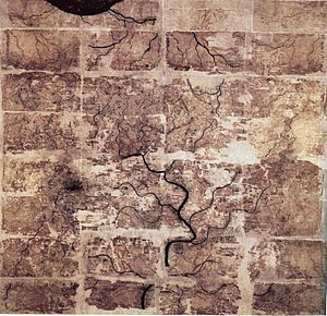
The earliest Chinese writings about geography date back to the 5th century BC. This was during the Warring States period. The Yu Gong ('Tribute of Yu') chapter of the Book of Documents describes the nine provinces of ancient China. It talks about their soil, products, trades, and rivers. This ancient text greatly influenced later Chinese geographers.
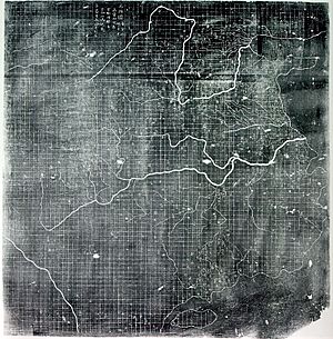
The earliest maps found in China are from the 4th century BC. They were made in the ancient State of Qin. The first known use of a geometric grid and a mathematically scaled map was by the cartographer Pei Xiu (224–271 AD). From the 1st century AD, Chinese historical texts included a geography section. These sections often listed changes in place-names, administrative divisions, mountains, and rivers.
Chinese geographical writing became more detailed and less legendary over time. For example, the Huainanzi (139 BC) described topography (the shape of the land) in a systematic way, using maps. The Shui Jing (Waterways Classic) from the 3rd century described about 137 rivers in China. In the 6th century, this book was greatly expanded by Li Daoyuan and renamed Shui Jing Zhu.
Later, during the Song dynasty (960–1279) and Ming dynasty (1368–1644), geography became even more systematic. The scholar Fan Chengda (1126–1193) wrote about the topography and products of China's southern provinces. The scientist Shen Kuo (1031–1095) wrote a lot about geography. He even had a theory about how land forms (geomorphology). He noticed marine fossils far inland and bamboo fossils underground in places where bamboo couldn't grow. This suggested that the land had changed over time.
Chinese geographers also documented foreign regions. Travelers like Zhang Qian (2nd century BC) wrote about the Middle East, India, and Central Asia. The Tang dynasty diplomat Wang Xuance traveled to India in the 7th century and wrote a book with lots of geographical information. Chinese geographers like Jia Dan (730–805) wrote accurate descriptions of distant places. He described the sea route into the Persian Gulf and mentioned "ornamental pillars" (lighthouses) that guided ships.
Middle Ages
Byzantine Empire and Syria
After the western Roman Empire fell, the Byzantine Empire (Eastern Roman Empire) continued to thrive. They produced important geographers. Stephanus of Byzantium (6th century) wrote a geographical dictionary called Ethnica. This book is very valuable for information about ancient Greece.
Hierocles (6th century) wrote the Synecdemus, which listed the administrative divisions and cities of the Byzantine Empire. These works are our main sources for understanding the political geography of that time.
George of Cyprus wrote Descriptio orbis Romani (Description of the Roman world) around 600-610 AD. He listed cities, towns, and divisions of the Byzantine Empire.
Cosmas Indicopleustes (6th century), also known as "Cosmas the Monk," was a merchant from Alexandria. He traveled to India, Sri Lanka, and Ethiopia. His work Christian Topography included some of the earliest world maps.
The Syrian bishop Jacob of Edessa (633–708) used scientific ideas from earlier thinkers like Aristotle and Ptolemy to create a detailed picture of the universe.
Islamic World
In the late 7th century, followers of Islam expanded their lands. They discovered and preserved Greek classic texts, including important geography works by Ptolemy. Arabs, who spoke only Arabic, hired Christians and Jews to translate these texts.
Most of the important geographical work during this time happened in Persia and at the House of Wisdom in Baghdad, Iraq. Many geographers were Persian or Syrian.
Some important Persian geographers and their contributions:
- Al-Khwārizmī (780–850) wrote The Image of the Earth. He improved on Ptolemy's maps of the Mediterranean, Asia, and Africa.
- Ibn Khurdadhbih (820–912) wrote Book of the Routes and Provinces, an early book on administrative geography. He made the first map with four sections.
- Al-Biruni (973–1052) described a way to project the celestial sphere onto a flat map. He was skilled at mapping cities and measuring distances. He calculated the Earth's circumference very accurately. His estimate was only 16.8 km less than the modern value!
- Avicenna (980–1037) wrote about Earth sciences in his Book of Healing.
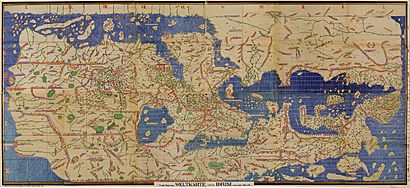
In the early 10th century, Abū Zayd al-Balkhī started the "Balkhī school" of map-making in Baghdad. These geographers wrote about the people, products, and customs of the Muslim world.
By the early 12th century, the Normans took over Sicily. Palermo became a hub for travelers. King Roger II was very interested in geography. He asked Al-Idrisi, an Arab geographer, to create a book and map that combined all the geographical information. Al-Idrisi created one of the most accurate world maps of its time, the Tabula Rogeriana (1154). This map, written in Arabic, shows all of Eurasia and northern Africa.
Medieval Europe
During the Early Middle Ages, geographical knowledge in Europe didn't advance much. Simple T and O maps became common.
However, the travels of Marco Polo in the 13th century, the Crusades, and later Portuguese and Spanish voyages of exploration opened up new horizons. The Mongols also had vast knowledge of Europe and Asia's geography. This helped them with their military expeditions.
In the 15th century, Henry the Navigator of Portugal supported explorations of the African coast. He became a leader in promoting geographical studies.
Early Modern Period
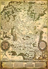
After Marco Polo's journeys, interest in geography grew in Europe. Around 1400, the writings of Ptolemy provided a system for organizing geographical information. This system was used by scholars for centuries.
European global conquests began in the early 15th century. Portugal explored Africa and India. Spain conquered America in 1492. These expeditions continued until the 18th century. This expansion led to the rise of colonial empires. It also caused the Columbian Exchange, where plants, animals, foods, people (including slaves), diseases, and cultures were exchanged between continents.
These colonial efforts in the 16th and 17th centuries created a need for accurate geographical details. Books like Geographia Generalis by Bernhardus Varenius and Gerardus Mercator's world map are examples of this new scientific geography.
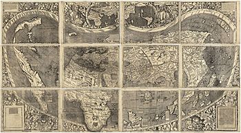
The Waldseemüller map Universalis Cosmographia, made in 1507, was the first map to use the name "America." Before this, Native Americans had their own names for their land, like "Abya Yala." Sadly, these local geographical ideas were often ignored by European colonialists.
16th-18th Centuries in the West
Geography became an exciting science during the Scientific Revolution. It also played a role in the Reformation. During the Victorian period, overseas exploration gave geography its own identity. It was seen as "the science of imperialism" because it helped empires expand.
New ideas and theories emerged in geography. However, the dominance of European male scholars often left out non-Western ideas and observations. For example, European thought often saw nature as separate from humans. But Native American ideas saw nature and humans as part of one system.
After the English Civil War, scientists like Samuel Hartlib promoted practical uses of science. William Cuningham showed how maps could be used for military purposes. John Dee used mathematics to study locations. The Reformation also encouraged geographical exploration. Bernhardus Varenius made geography a science in the 17th century with his book Geographia Generalis. This book was even used by Isaac Newton when he taught geography at Cambridge.
Science developed with empiricism, which means gaining knowledge from experience and observation. Geographical knowledge became important for economics and administration. Foreign travels provided information for research and helped form theories, like environmental determinism. Map-making became important for its practical, theoretical, and artistic value.
The ideas of "Space" and "Place" became important in geography. Thinkers like Descartes, John Locke, and Gottfried Wilhelm Leibniz discussed whether space was absolute or relative. Locke believed that "Our Idea of Place is nothing else, but such a relative Position of any thing."
During the Age of Enlightenment, scientific advancements led to more exploration of nature. David Hume emphasized the importance of scientific observations. Scientists like Galileo, Descartes, and Newton saw the universe as a machine. Immanuel Kant also contributed to the idea of cosmic evolution.
Francis Bacon believed that science and technology would improve humanity. Jean-Jacques Rousseau focused on human emotions and morals. His ideas led to local regional studies in geography education. Kant tried to combine sense and reason. He saw physical geography as a natural science. He gave lectures on physical geography and published notes in 1801.
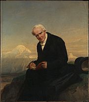
Alexander von Humboldt is considered a great geographer. He had a holistic view of geography and nature. His work Kosmos (1845) was a huge achievement. It aimed to describe the physical universe. Humboldt used empirical methods to study indigenous people in the New World. He called this a new science: Physique du monde or Geographie physique.
Institutions like the Royal Geographical Society showed that geography was becoming its own field. Mary Somerville's Physical Geography was a key work that integrated different areas of knowledge.
19th Century
By the 18th century, geography was recognized as a separate subject. It became part of university studies in Europe, especially in Paris and Berlin.
A key work from this time was Alexander von Humboldt's Kosmos, published in 1845. This book was so powerful that Mary Somerville almost didn't publish her own Physical Geography after reading it. Humboldt encouraged her to publish anyway.
In 1877, Thomas Henry Huxley published his Physiography. This work presented an integrated way to study the natural environment. It emphasized collecting data and applying findings from small-scale observations to larger ones. However, this approach was soon replaced by other ideas in geography.
Over the past two centuries, our knowledge and tools in geography have grown a lot. Geography has strong links with sciences like geology and botany, as well as economics, sociology, and demographics.
The Royal Geographical Society was founded in England in 1830. The first full professor of geography in the UK was appointed in 1917. Halford John Mackinder was an important geographer at Oxford University starting in 1887.
The National Geographic Society was founded in the United States in 1888. It started publishing National Geographic magazine, which made geographical information popular. The society still supports geographical research and education today.
20th Century
In the West, geography went through four main phases in the late 19th and 20th centuries: environmental determinism, regional geography, the quantitative revolution, and critical geography.
Environmental Determinism
Environmental determinism was a theory that said a people's physical, mental, and moral traits were directly caused by their natural environment. For example, some believed that "heat makes people in hot places lazy." This idea was widely rejected around the 1930s because it lacked proof and often led to unfair generalizations.
Regional Geography
Regional geography focused on studying specific places (regions). Geographers in this area collected descriptive information about places and how to divide the Earth into regions. Richard Hartshorne defined geography as the study of how areas differ. This approach was later criticized for being too descriptive and not scientific enough.
However, regional geography is still popular among students. It helped people understand foreign cultures and how borders affect the real world.
The Quantitative Revolution
The quantitative revolution in geography began in the 1950s. Geographers started using statistical methods to test their theories. This led to the development of geographic information systems (GIS). A key idea from this period is Tobler's first law of geography, which states: "everything is related to everything else, but near things are more related than distant things."
Critical Geography
Critical geography came about as a critique of earlier approaches. One type was humanistic geography. It focused on people's feelings and relationships with places.
More influential was Marxist geography, which used the ideas of Karl Marx to understand geographical patterns. David Harvey is a well-known Marxist geographer. Feminist geography applies ideas from feminism to geographical topics.
The newest type of critical geography is postmodernist geography. It uses ideas from postmodernism to explore how our understanding of space is shaped by society.
See also
 In Spanish: Historia de la geografía para niños
- Cartography
- Chorography
- Economic geography
- Geographers on Film
- Human geography
- List of explorers
- List of geographers
- List of maritime explorers
- Physical geography
- Royal Geographical Society
- Royal Scottish Geographical Society
 | William L. Dawson |
 | W. E. B. Du Bois |
 | Harry Belafonte |


