
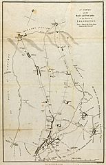
Image: Survey of the Roads and Foot paths in the Parish of Islington

Size of this preview: 385 × 599 pixels. Other resolutions: 154 × 240 pixels | 3,666 × 5,702 pixels.
Original image (3,666 × 5,702 pixels, file size: 3.28 MB, MIME type: image/jpeg)
Description: This map extends from Battle Bridge to Highgate and from Cruch End to Kings Land and the boundary to Shoreditch. Toll gates are also marked in various places.
Title: Survey of the Roads and Foot paths in the Parish of Islington
Credit: The Yale Centre for British Art, where it's copyright status is given as 'Public Domain' [ See: https://collections.britishart.yale.edu/catalog/tms:36625 ]
Author: Anon (1735). Engraved by John Hawksworth in 1811.
Usage Terms: Creative Commons Zero, Public Domain Dedication
License: CC0
License Link: http://creativecommons.org/publicdomain/zero/1.0/deed.en
Attribution Required?: No
Image usage
The following page links to this image:

All content from Kiddle encyclopedia articles (including the article images and facts) can be freely used under Attribution-ShareAlike license, unless stated otherwise.