
History of Stroud Green facts for kids
Stroud Green is a lively part of London, England, located next to Finsbury Park. Most of it is in the London Borough of Haringey, while a small part is in the London Borough of Islington. The main street, Stroud Green Road, forms the border between these two areas. It's a busy street with lots of popular shops, restaurants, and cafes.

Long ago, Stroud Green Road was also the boundary between the old church areas of Islington and Hornsey. This part of Hornsey used to stretch even further into what is now Hackney. An old tavern called the Eel Pie House was once located here, right by the New River. The New River used to flow above ground in this area, first in a wooden structure and later on a raised earth bank. Today, the New River runs underground.
Records of Stroud Green go back to the early 1400s. However, you won't find much physical evidence of its ancient past today. Most of the buildings you see are houses built in the late 1800s. Some parts of Stroud Green were damaged during World War II by bombs. After the war, the local council built new public housing in these areas. Since 2003, much of Stroud Green has been named a "Conservation Area." This means it's a special place with historical interest that people want to protect and improve.
Contents
- What's in a Name? The Meaning of Stroud Green
- Who Owned the Land in Stroud Green?
- How Stroud Green Grew Over Time
- Getting Around: Roads and Railways
- Places of Worship
- Interesting Buildings (Still Standing!)
- Interesting Buildings (No Longer Here!)
- Who Lives in Stroud Green? (Demographics)
- Schools and Learning in Stroud Green
- Images for kids
What's in a Name? The Meaning of Stroud Green
The name "Stroud Green" has a cool history! In 1407, this area was called Strode. This word comes from an old English word meaning "marshy ground covered with bushes." Later, in 1546, it was recorded as Stowde Grene. The "grene" part is a Middle English word for "village green" or open grassy area. A small stream, the Stroud Green brook, used to flow through the southern part of the area.
Who Owned the Land in Stroud Green?
It's a bit tricky to find all the old records about land ownership in Stroud Green. In 1811, people said that Stroud Green was a large piece of common land. It belonged to people who held land under a special old system called copyhold from Highbury Manor.
In the 1500s, a London brewer named John Draper owned some of Stroud Green. When he died in 1576, his land included about 73 acres between Stroud Green Road and Brownswood. It also included 32 acres between Brownswood and Green Lanes. His family continued to own parts of this land for many years.
Later, in the 1600s, Sir William Paul owned about 110 acres of Stroud Green. This land was then passed down through his family. By the late 1700s and early 1800s, a family named Lucas owned a large part of this land. By 1880, houses were built all over this area.
The Corporation of Stroud Green: A Fun Group!
In the 1700s, London newspapers talked about a group called the "Corporation of Stroud Green." This wasn't a formal government group like today. It was more like a social club or a community group.
Newspaper reports show that these "Corporations" were quite common back then. They even connected with other similar groups, like the "Corporation of Kentish Town." They would have annual meetings and celebrations.
One of their main activities seemed to be "beating the bounds." This was an old tradition where people would walk the boundaries of their land to make sure everyone knew who owned what. Even though property rights are serious, the Stroud Green Corporation sometimes had funny moments during these walks!
For example, in 1765, their "Sword-Bearer" (a person who carried a special sword for the group) drank too much. He fell over and lost his small gold sword, which was a symbol of his job!
No matter their official duties, the Corporation always seemed to have a good time. They would have fancy dinners, drink toasts to the King, and even have balls (dances). The last records show them meeting at taverns and even going to the Sadlers Wells theatre.
The Corporation's Special Items
The Victoria and Albert Museum in London has a special badge from The Corporation. It's made of enamel and shows Saint George fighting the dragon. It's dated 1773.
There was even a song for the group! It was called The Song for the Ancient Corporation of Stroud Green. It appeared in a songbook from 1773. The song talks about having fun, being fair, and being proud of their group. It even mentions their motto: Justitia floreat, ut noi ab origine which means "May Justice flourish, as we have from the beginning."
How Stroud Green Grew Over Time
The 1800s: A Time of Fast Growth
Until the mid-1800s, Stroud Green was mostly open land. There were very few houses between Crouch End and Archway Road. Only a few cottages existed near the present-day Seven Sisters Road. The old Eel-Pie house was there, later becoming the Highbury Sluice House tavern.
.jpg)
Modern Stroud Green really started to grow in the 1800s. Building was slow at first, partly because of poor sewage systems. But things changed quickly after the 1860s. New railway stations opened at Finsbury Park, Crouch Hill, Crouch End, and the new Stroud Green station. These made it much easier for people to travel to and from London.
In 1863, land was leased for building, and by 1868, Mount Pleasant Road was built. Houses started popping up everywhere. The growth was so fast that the 1871 census (a count of the population) was already out of date by 1875!

By the 1870s, Stroud Green was becoming part of a larger urban area called Finsbury Park. It was a new and quickly growing neighborhood with a strong community spirit. Many people living here were commuters, meaning they traveled to work in other parts of London. By 1896, almost all the land in Stroud Green was built up.
The 1900s: Changes and Rebuilding
Between 1901 and 1911, the population in Stroud Green actually went down. Families were getting smaller, so houses were often divided into multiple apartments or flats. This led to lower living standards in some areas.

During World War II, Hornsey (the larger area Stroud Green is part of) was heavily bombed. Over 80% of houses were damaged. After the war, the Hornsey Council started a big rebuilding project in Stroud Green. Many old areas were cleared, and new public housing blocks were built. Wall Court, a building with balconies, was finished in 1947 and was much admired. Other blocks like Lawson, Wiltshire, and Marquis courts were built in 1948. This rebuilding continued into the 1950s and 60s.
Today: A Valued Conservation Area
In 2003, Haringey Council officially named Stroud Green a "Conservation Area." This means it's recognized as a place with "special character or historic interest" that should be protected and improved.

The council decided this because Stroud Green has some of the best examples of Victorian houses in Haringey. You can see many different styles from the 1800s, from simple cottages to grander homes with fancy details. The early houses from the 1870s often have Gothic styles, with pointed windows and colorful brickwork. Later houses, built after 1882, show the "Queen Anne" style, with red brick and simpler designs.
The architecture in Stroud Green is still mostly original, which is rare. It's a unique example of an area that shows the full range of house styles from the late 1800s.
Getting Around: Roads and Railways
Roads in Stroud Green
Stroud Green Road is the main road through the area. It's a very old route that used to lead out of London. In the past, this road and Crouch Hill were known as Tallingdon Lane.
.jpg)
Because the area was low-lying and had heavy clay soil, the roads often became very muddy and hard to use in bad weather. In the 1300s, some roads in Hornsey were said to be "impassable" in winter! Local people often had to raise money to fix the roads themselves. For example, in 1764, people in Crouch End and Stroud Green collected money to repair their "ruinous" roads.
Even today, there can sometimes be confusion about who is responsible for maintaining Stroud Green Road. The eastern side is looked after by Haringey Council, and the western side by Islington Council.
In 1832, the Seven Sisters Road was built. This new road helped connect Islington to Tottenham. Other new streets built in the 1800s, like Endymion Road and Ferme Park Road, also helped improve travel in the area.
You can still see a cool piece of history on Mount Pleasant Crescent. The first 50 yards of the road are paved with old brick cobblestones from the 1800s. They're still in great condition!
Railways in Stroud Green
Stroud Green has two railway stations today: Finsbury Park station at one end and Crouch Hill station at the other. There used to be a Stroud Green station, but it's no longer in use.
In 1862, a railway line was built from Finsbury Park through Stroud Green to Edgware. Stroud Green station opened in 1881. Over time, other branch lines were added, but many of them closed down. By 1954, the entire line from Finsbury Park to Highgate was closed to passengers. Today, the old railway track between Finsbury Park and Highgate is a walking path called the Parkland Walk.
Places of Worship
Anglican Churches
The first Anglican church in Stroud Green, Holy Trinity, was built between 1880 and 1885. It was a large, dignified church with 1,200 seats.
.jpg)
Sadly, the church was damaged during World War II and had to be pulled down in 1960. A new church hall and public garden were built on the site. The church's organ was moved to another church. Today, Holy Trinity church continues to be an active part of the community.

Baptist Churches
The Stroud Green Baptist chapel on Stapleton Hall Road was built in 1889. It was a red-brick building with adjoining halls. In 1903, many people attended services there. The chapel building has since been turned into apartments, and the Baptist church now holds its services in what was once its hall.

Roman Catholic Churches
In 1893, Roman Catholic residents in Stroud Green started raising money for a church. They bought a house and began holding mass there. A new red-brick church, called St. Peter-in-Chains, was built between 1898 and 1902. It is still an active church today.

Other Churches and Missions
- Ceylon and India General Mission: In 1912, the offices for this mission were located on Stapleton Hall Road.
- Christian Scientists: This group met on Stroud Green Road from about 1912 to 1923.
- Congregationalists: A Congregational church was built on Mount View Road and Granville Roads in 1893. It was a large church that could seat 1,000 people. However, it was closed and torn down in 1935.
- Plymouth Brethren: In 1903, this group met at 45 Woodstock Road. Smaller groups also met at 33 Stroud Green Road.
Interesting Buildings (Still Standing!)
The Old Coal Office
.jpg)
Before gas and electric heating, people used coal fires to keep warm. Small offices like this one, near railway stations, were where people ordered coal. This building, which used to be a coal office, is now an office for a local taxi business.
The Covered Reservoir
.jpg)
Built around 1885, the covered reservoir sits on a ridge near Mount View Road. It offers amazing views over London, all the way to the Thames estuary and even to Crystal Palace on a clear day!
The Old Dairy Building
This building, now a pub, was once owned by the Friern Manor Dairy Company. It's located on the corner of Hanley Road and Crouch Hill.

The outside wall facing Crouch Hill has seven unique and beautiful sgraffito panels. These are pictures scratched into the plaster, showing scenes like milk delivery (old and new), cows grazing, and making butter. They were created around 1890.
Stapleton Hall
Stapleton Hall is a historic building on Stapleton Hall Road. There are different ideas about who originally owned it. Some believe it belonged to the Stapleton family, while others think it was the Draper family.

By the 1760s, the building was being used as a tavern called The Green Man. Newspaper reports from that time give us a glimpse of what it was like. In 1769, the landlord's widow auctioned off everything inside, including 14 beds, clocks, kitchen items, brewing equipment, two carts, three cows, and pigs!
.jpg)
Later, it became a farm. In the late 1800s, Charles Turner, a well-known farming family member, lived there. By 1888, Stapleton Hall became the Stroud Green Conservative club, which owned it until at least 1978. The building has been changed a lot over the years and is now apartments.
The Old Telephone Exchange
.JPG)
At 39A Stroud Green Road, you'll find a building that looks like it was built in 1896, but it was actually built in 1911. This was once the local telephone exchange and public call office for the National Telephone Company. It was a very important place before most homes had their own telephones.
Interesting Buildings (No Longer Here!)
1 Ferme Park Road

This building, once the Triangle Restaurant, was torn down after 2016. Its history might have been connected to the old railway nearby.
The Scala Cinema
Near Finsbury Park station, there used to be an old brick building that was once the Scala Cinema. It opened in 1914 and could seat 700 people. It was renamed the New Scala Cinema in 1920 but closed in 1924.
.JPG)
After closing as a cinema, the building was used for many different things: a billiard hall, a wartime factory, an Irish dancing school, and a whist hall. It was suddenly torn down in June 2008. Now, a block of flats with a supermarket stands on the site.
Stapleton Hall Road Coal Offices
These buildings were once coal offices located on a railway bridge over the Gospel Oak to Barking railway. They were used until recently as a small house and a shoe repair shop. They were torn down in late 2012 to make way for new housing.
.jpg)
.jpg)
Stroud Green Assembly Rooms
In the late 1800s, there were plans to build "assembly rooms" or a concert hall in Stroud Green. The plans showed a hall that could seat 280 people, with shops below. It seems the building was never fully completed as planned, but some parts of the brick buildings behind an existing shop might be from this project.


Stroud Green House
This large, detached house, also known as Prouse House, once stood in the area bordered by Stroud Green Road, Stapleton Hall Road, Victoria Road, and Albert Road. A street called Prouse Terrace is named after it. This house was once the home of William Prowse, who started the famous music business and ticket agency, Keith, Prowse and Co.
Stroud Green Station

The Stroud Green station opened in 1881 on Stapleton Hall Road. It was part of a railway line that connected Finsbury Park to Edgware. A branch line also went to Alexandra Palace. However, passenger services on this line stopped in 1954. Today, the old railway track is a popular walking path called the Parkland Walk.
Womersley House

Womersley House was a large house near the St Peter-in-Chains Catholic church. It was home to the Turner family, who were important landowners in the late 1800s. Later, in the early 1900s, it became a hostel for single working women. The house was torn down in the 1960s, and the site has since been redeveloped.
Who Lives in Stroud Green? (Demographics)
Compared to the rest of the Borough of Haringey, Stroud Green has:
- More residents aged 25 to 44.
- More single-person households.
- More residents with university degrees (higher than the London average).
- A higher proportion of white-British residents.
- More people who say they have no religion or prefer not to state one.
- More people in professional and managerial jobs.
- Fewer households in public housing.
- Fewer people claiming benefits.
- Better overall health levels.
Schools and Learning in Stroud Green
Education in the Past
In 1659, Roger Draper of Stroud Green left money to help six poor boys from Hornsey become apprentices in London trades.
.JPG)
Number 175 Stroud Green Road, built in the 1860s, started as a girls' school. Later, it became the home of George Osborne Barratt, who founded the famous Barratt sweets company. By 1899, it was a large shop owned by a draper named David Hall.
In 1890, Stroud Green had at least 21 private schools! These included early versions of St. Aidan's Primary School and Hornsey High School for Girls. There were also two grammar schools for boys run by churches.
_.JPG)
The Stapleton Hall School for Girls was run by the Misses Elfick from 1898 until 1935. Other schools in the area included Hornsey Rise College and Victoria College.
.JPG)
The Stroud Green and Hornsey High School for Girls opened in 1887. It was on a small site and didn't have a playground. In 1948, it became an elementary school called St. Aidan's.
.JPG)
Another school, the Stroud Green (Girls) High School, started around 1887. In 1908, it was taken over by the Middlesex County Council and became Hornsey High School for Girls. It later moved to new buildings and eventually absorbed the Stroud Green and Hornsey High School for Girls.
For children who relied on free education, things were harder. In 1890, there was no free public elementary school in Stroud Green. Middle-class families in the area actually opposed having one. This meant that many Stroud Green children had to go to schools in neighboring areas, becoming known as "border children."
.JPG)
.JPG)
Finally, the Stroud Green Board School opened in temporary buildings in 1894. In 1896, it moved into a new building on Woodstock Road. It had separate floors for boys, girls, and infants.
Education Today
For more information about schools in Stroud Green today, you can look at the London Borough of Haringey article.
Images for kids
-
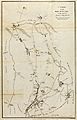
A map of footpaths and roads in Islington parish from 1735, showing Stroud Green.

