
Image: Syria in the 9th century

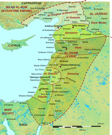
Description: Map of Islamic Syria and its provinces (ajnad, sing. jund, of Qinnasrin, Palestine (Filastin), Jordan (al-Urdunn), Damascus (Dimashq), Hims, al-'Awasim) under the Abbasid Caliphate in the 9th century Source map: Battle of the Mills.svg; Sources for settlements and provincial borders: W.E. Kaegi, Byzantium and the early Islamic conquests. Cambridge 1995, p. 241; The New Cambridge History of Islam, Vol. 1: The Formation of the Islamic World, Sixth to Eleventh Centuries. Cambridge and New York 2011, p. xxxv; Hugh N. Kennedy, The Prophet and the Age of the Caliphates: The Islamic Near East from the 6th to the 11th Century (Second ed.). Harlow 2004, p. 404. Note that borders varied somewhat over time (e.g. sometimes Amman was part of Jund Filastin, etc.)...
Title: Syria in the 9th century
Credit: Own work This vector image includes elements that have been taken or adapted from this file: Battle of the Mills.svg.
Author: Constantine Plakidas
Usage Terms: Creative Commons Attribution-Share Alike 3.0
License: CC BY-SA 3.0
License Link: https://creativecommons.org/licenses/by-sa/3.0
Attribution Required?: Yes
Image usage
The following 4 pages link to this image:
