
Image: TS Helene 15 sept 2006 1610Z

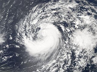
Description: Hurricane Helene was the eighth named storm of the 2006 Atlantic hurricane season. The tropical depression (area of low air pressure) from which it formed began intensifying and forming a tropical storm system south of the Cape Verde Islands on September 12. The system crossed the Atlantic Ocean over the course of several days, gathering power as it went. By the morning of September 17, it was a powerful Category 3 hurricane. This photo-like image was acquired by the Moderate Resolution Imaging Spectroradiometer (MODIS) on NASA’s Aqua satellite on September 15, 2006, at 12:10 p.m. local time (16:10 UTC). Helene was still a tropical storm at this point in time, but hours from reaching Category 1 hurricane status. This MODIS image of Helene shows the hallmarks of a storm system in the act of intensifying, with a tightly wound core around hints of a forming eye, some developing spiral-arm structure, and to the south and west of the storm, a radial cloud pattern seen in many hurricanes. The spiral structure is incomplete and highly asymmetric, more typical of a tropical storm than a hurricane. Tropical Storm Helene had sustained winds of around 110 kilometers per hour (70 miles per hour) at the time this satellite image was acquired, according to the University of Hawaii’s Tropical Storm Information Center. These speeds placed the storm just below the threshold of hurricane status. While only the second major (Category 3 or higher) hurricane of the season, Helene comes immediately on the heels of the first, Hurricane Gordon. As of September 17, storm track projections showed a reasonable probability of Helene passing near Bermuda. The island was still recovering from an indirect hit from Hurricane Florence just two weeks earlier and from storm surge and strong surf from a more distant Hurricane Gordon.
Title: TS Helene 15 sept 2006 1610Z
Credit: http://earthobservatory.nasa.gov/NaturalHazards/natural_hazards_v2.php3?img_id=13870
Author: NASA image created by Jesse Allen, Earth Observatory, using data provided courtesy of the MODIS Rapid Response team.
Permission: Public domainPublic domainfalsefalse This file is in the public domain in the United States because it was solely created by NASA. NASA copyright policy states that "NASA material is not protected by copyright unless noted". (See Template:PD-USGov, NASA copyright policy page or JPL Image Use Policy.) Warnings: Use of NASA logos, insignia and emblems is restricted per U.S. law 14 CFR 1221. The NASA website hosts a large number of images from the Soviet/Russian space agency, and other non-American space agencies. These are not necessarily in the public domain. Materials based on Hubble Space Telescope data may be copyrighted if they are not explicitly produced by the STScI.[1] See also Template:PD-Hubble and Template:Cc-Hubble. The SOHO (ESA & NASA) joint project implies that all materials created by its probe are copyrighted and require permission for commercial non-educational use. [2] Images featured on the Astronomy Picture of the Day (APOD) web site may be copyrighted. [3] The National Space Science Data Center (NSSDC) site has been known to host copyrighted content. Its photo gallery FAQ states that all of the images in the photo gallery are in the public domain "Unless otherwise noted."
Usage Terms: Public domain
License: Public domain
Attribution Required?: No
Image usage
The following page links to this image:
