
Hurricane Helene (2006) facts for kids
| Category 3 major hurricane (SSHWS/NWS) | |

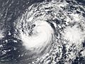
Hurricane Helene near peak intensity.
|
|
| Formed | September 12, 2006 |
|---|---|
| Dissipated | September 24, 2006 |
| Highest winds | 1-minute sustained: 120 mph (195 km/h) |
| Lowest pressure | 955 mbar (hPa); 28.2 inHg |
| Damage | None |
| Areas affected | Northern British Isles (while extratropical) |
| Part of the 2006 Atlantic hurricane season | |
Hurricane Helene was a very powerful storm during the 2006 Atlantic hurricane season. It was one of the strongest hurricanes that year, as strong as Hurricane Gordon. Helene was the ninth tropical storm, the fourth hurricane, and the second major hurricane of the season.
Helene was a special type of hurricane called a Cape Verde-type hurricane. These storms start near the Cape Verde islands off the coast of Africa. When Helene was at its strongest, it was a Category 3 hurricane on the Saffir-Simpson Hurricane Scale. This means it had very strong winds. Helene traveled across the middle of the Atlantic Ocean but never hit land directly. It only affected the northern British Isles at the very end of its life, when it was much weaker.
Contents
How Hurricane Helene Formed and Grew

In early September, a strong weather system, called a tropical wave, moved off the coast of Africa. Weather experts at the National Hurricane Center thought it could quickly become a tropical depression. This happened on the morning of September 12, and it was named Tropical Depression Eight.
This depression was very large, so it grew slowly at first. It also faced some winds that slowed it down, and dry air from the Saharan Air Layer. However, on September 13, the depression got stronger and became Tropical Storm Helene. The storm slowly gained power as it moved over the warm waters of the eastern Atlantic.
Dry air continued to slow Helene's growth on September 14. But on September 15, the winds became calmer, and Helene suddenly started getting much stronger.

On the morning of September 16, Helene became Hurricane Helene. It started to form a clear "eye" in its center. For a while, it stayed as a weak Category 1 hurricane. This was because of some medium winds that kept it from getting too strong. But late that evening, the storm began to slowly get stronger again.
Helene Becomes a Major Hurricane
On September 17, Helene got much stronger, very quickly. It became a Category 2 hurricane that morning. Its eye became clearer, surrounded by strong thunderstorms. Helene also started to turn more towards the north and slowed down. This turn kept the hurricane away from land. Helene continued to strengthen, and that evening, it became a large hurricane with winds of 115 mph (185 km/h).
Because the winds stayed calm and the ocean water was warm, Helene got even stronger. Early on September 18, it reached its peak strength as a strong Category 3 hurricane, with winds of 120 mph (195 km/h). At this time, Helene and Hurricane Gordon were both in the open ocean, at about the same longitude.
Helene Weakens and Changes
As Gordon moved away on September 18, Helene turned westward. The center of Helene's eye became less clear, and it weakened back to a Category 2 hurricane. It stayed at this strength for about two days, until September 20. This was due to a long process where the storm's eye changed shape. On the 20th, Helene turned northwest again and weakened a bit more because of stronger winds. That afternoon, it was downgraded to a Category 1 hurricane. Helene remained a Category 1 hurricane until it changed into a different type of storm.

Early on September 21, Helene started moving north. It then began to turn northeast that evening, moving along the edge of a weather system east of Bermuda. Even though it was moving into cooler waters, Helene stayed a Category 1 hurricane. This was because the winds were calm and the water was still quite warm. Its strength stayed around 80 mph (130 km/h). It even got a little stronger late on September 22, reaching 90 mph (145 km/h) winds.
Helene then started to become a "hybrid" storm on the afternoon of September 23. This means it had features of both a tropical storm and a non-tropical storm. After this, stronger winds caused Helene to weaken again. However, it stayed hurricane-strength until it fully changed into an extratropical cyclone on the morning of September 24. After this change, the storm weakened further as it moved east. It became a gale (strong wind) center west of Ireland on September 27. It eventually joined with a larger weather system near the northern British Isles later that day.
Helene's Impact
While Helene was a tropical hurricane, it never came close to land. Three ships were caught in the outer parts of Helene. One ship reported winds of 56 mph (91 km/h) on September 23. Even though it stayed far away, the hurricane caused rough waves in Bermuda.
When Helene was a weaker, non-tropical storm, it brought strong winds to Ireland and northern Scotland.
- In Ireland, the strongest wind gust was 56 mph (91 km/h) at the Valentia Observatory.
- In Scotland, the strongest gust was 74 mph (118 km/h) on South Uist Island.
No damage or deaths were reported because of Hurricane Helene.
Related pages
- The NHC's archive on Hurricane Helene.
|
Tropical cyclones of the 2006 Atlantic hurricane season |
||||||||||||||||||||||||||
|
|
|||||||||||||||||||||||||
|
|
||||||||||||||||||||||||||
Images for kids
-
Tropical Storm Helene intensifying on September 15

