Tropical Storm Debby (2006) facts for kids
| Tropical storm (SSHWS/NWS) | |

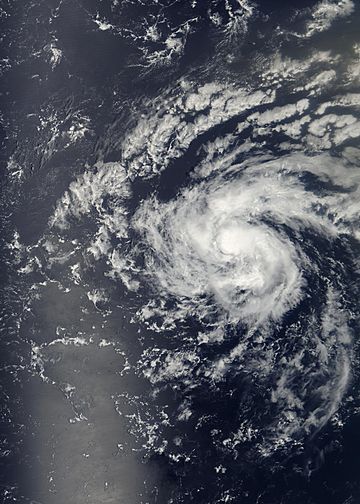
Tropical Storm Debby on August 24, 2006.
|
|
| Formed | August 21, 2006 |
|---|---|
| Dissipated | August 26, 2006 |
| Highest winds | 1-minute sustained: 50 mph (85 km/h) |
| Lowest pressure | 999 mbar (hPa); 29.5 inHg |
| Damage | None |
| Areas affected | Cape Verde |
| Part of the 2006 Atlantic hurricane season | |
Tropical Storm Debby was the fifth tropical storm during the 2006 Atlantic hurricane season. It started as a tropical wave near Africa on August 21. Debby then moved past the Cape Verde islands. For most of its life, it traveled northwest.
The storm reached its strongest point with winds of 50 mph (85 km/h). However, strong winds high in the atmosphere, called wind shear, made the storm weaker. Debby eventually faded away on August 27 over the northern Atlantic Ocean.
At first, experts thought Debby might hit the southern Cape Verde islands. They worried it could cause dangerous flooding. Most computer models showed Debby moving northwest. But it was harder to guess how strong it would get. The National Hurricane Center thought Debby would become a hurricane. Yet, strong wind shear stopped it from getting that powerful.
Contents
How Tropical Storm Debby Formed and Moved
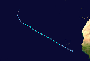
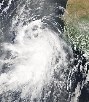
A strong tropical wave left the coast of Africa on August 20. This wave had some rain bands and a wide area of low pressure. The next day, a large area of low pressure formed within the wave. This was about 260 miles southeast of the Cape Verde islands.
Even though the rain clouds decreased, the low-pressure area stayed organized. It became Tropical Depression Four late on August 21. The ocean water was warm enough for the storm to grow. Also, there was not much wind shear high up. The depression moved west-northwest because of a high-pressure system to its north.
Experts at the National Hurricane Center thought it would turn northwest. They based this on computer models. One forecaster, James Franklin, even said, "The models have also been excellently wrong thus far."
Even with less rain, the large depression stayed well organized. It had a wide wind field, about 575 miles across. On August 22, it passed 140 miles (225 km) south of the Cape Verde islands. Strong rain clouds then grew over the center of the storm.
Early on August 23, the depression became Tropical Storm Debby. This was about 300 miles southwest of Cape Verde. The rain bands continued to organize as the storm slowly got stronger. On August 23, Debby reached its strongest point with winds of 50 mph. This happened over the open Atlantic Ocean. Forecasters believed Debby would keep getting stronger and become a hurricane. Its path showed it moving into an area with warm water and moderate wind shear.
Debby Weakens and Disappears
Soon after reaching its peak strength, Debby moved into an area of dry air. This made the storm weaker. The lower part of the storm separated from the dying rain clouds. The whole system kept moving west-northwest.
However, rain clouds started to form again over part of the center. The rain bands also reformed. The storm became organized once more. On August 24, Debby again reached its peak strength of 50 mph.
But winds from the south pushed the rain clouds away from the center. Debby weakened to a mild tropical storm on August 25. The center of the storm became uneven and stretched out. On August 26, Debby weakened to a tropical depression. There was very little rain, and it quickly turned into a leftover area of low pressure. This low-pressure area then moved north and north-northeast. It was ahead of an approaching trough, which is like a dip in air pressure. On August 28, the low pressure area finally disappeared.
How Debby Affected People
The government of the Cape Verde islands issued tropical storm warnings. This happened when Tropical Depression Four was first announced. This meant tropical storm conditions were expected within 24 hours.
The National Hurricane Center warned that heavy rainfall was possible. It could be as much as 10 inches in mountain areas. This rain might cause dangerous flash floods and mudslides.
However, the storm changed its path and moved further south. Because of this, the tropical storm warnings were canceled. The depression passed about 115 miles southwest of the islands. It caused a 35 mph wind gust at Fogo and some rain. But no damage was reported.
Long-range forecasts showed the storm might get close to Bermuda. But Debby stayed more than 900 miles away from the island at its closest point.
Even though the storm was expected to stay far from the Gulf of Mexico, some investors watched it closely. They thought it might affect oil platforms. This caused the price of crude oil to go up by 60 cents a barrel.
Related pages
|
Tropical cyclones of the 2006 Atlantic hurricane season |
||||||||||||||||||||||||||
|
|
|||||||||||||||||||||||||
|
|
||||||||||||||||||||||||||
See also
 In Spanish: Tormenta tropical Debby (2006) para niños
 | Jackie Robinson |
 | Jack Johnson |
 | Althea Gibson |
 | Arthur Ashe |
 | Muhammad Ali |


