
2006 Atlantic hurricane season facts for kids
 |
|
| Season summary map | |
| First storm formed | June 10, 2006 |
|---|---|
| Last storm dissipated | October 2, 2006 |
| Strongest storm | Gordon and Helene – 955 mbar (hPa) (28.21 inHg), 120 mph (195 km/h) (1-minute sustained) |
| Total depressions | 10 |
| Total storms | 10 |
| Hurricanes | 5 |
| Major hurricanes (Cat. 3+) | 2 |
| Total fatalities | 14 total |
| Total damage | $504.42 million (2018 USD) |
| Atlantic hurricane seasons 2004, 2005, 2006, 2007, 2008 |
|
| Related article | |
The 2006 Atlantic hurricane season was a period when tropical storms and hurricanes formed in the Atlantic Ocean. It officially started on June 1, 2006, and ended on November 30, 2006. During this time, ten tropical storms formed. Five of these storms grew strong enough to become hurricanes. One tropical storm did not even get a name at the time. This season affected the state of Florida in the USA.
What was special about this season was that no hurricanes hit the USA. Also, a storm from the 2005 season, Tropical Storm Zeta, lasted into January 2006. This was only the second time a tropical storm had existed in two different calendar years.
After a very busy 2005 hurricane season, experts thought 2006 would also be active. However, a weather pattern called El Niño and a layer of dry, dusty air from the Sahara Desert over the Atlantic Ocean made the season much quieter than expected. These conditions caused all tropical storms to disappear after October 2.
Contents
Storms of 2006
Tropical Storm Alberto
| Tropical storm (SSHS) | |||
|---|---|---|---|
|
|||
| Duration | June 10 – June 14 | ||
| Intensity | 70 mph (110 km/h) (1-min), 995 mbar (hPa) | ||


On June 10, a group of thunderstorms formed and became the first tropical depression of the year. This storm moved towards Florida. By the morning of June 11, it had become a tropical storm. The warm waters in the Gulf of Mexico helped Alberto get stronger. However, it weakened a bit over cooler waters near the US coast.
Alberto reached the coast about 50 miles southeast of Tallahassee, Florida on June 13. Some areas like Cedar Key and Crystal River were flooded by high waves from Alberto. Because Alberto was a large storm, it took a long time to weaken as it moved over Georgia, South Carolina, and North Carolina. Alberto then moved northeast and changed from a tropical storm to an extratropical cyclone (a storm that gets its energy from temperature differences, not warm ocean waters). As an extratropical storm, Alberto quickly became stronger off the New England coast. The damage in the United States was about $565,000.
Unnamed Tropical Storm
| Tropical storm (SSHS) | |||
|---|---|---|---|
|
|||
| Duration | July 17 – July 18 | ||
| Intensity | 50 mph (85 km/h) (1-min), 998 mbar (hPa) | ||


In July, a tropical storm formed off the coast of the United States. At the time, weather experts did not realize it was a storm, so it was not given a name. It was only identified as a tropical storm after a careful review at the end of 2006. If it had been identified earlier, it would have been named Beryl.
Tropical Storm Beryl
| Tropical storm (SSHS) | |||
|---|---|---|---|
|
|||
| Duration | July 18 – July 21 | ||
| Intensity | 60 mph (95 km/h) (1-min), 1000 mbar (hPa) | ||


In the middle of July, several areas of low pressure formed off the United States. The one farthest south slowly moved south and became more organized a few hundred miles east of the North Carolina coast. On the morning of July 18, this low-pressure area became the second tropical depression of the season. That afternoon, it grew into Tropical Storm Beryl.
Beryl continued moving north, then turned northeast on July 20. It moved along the East Coast of the United States and passed over Nantucket Island. After that, it changed into an extratropical storm southwest of Nova Scotia on July 21.
Tropical Storm Chris
| Tropical storm (SSHS) | |||
|---|---|---|---|
|
|||
| Duration | July 31 – August 5 | ||
| Intensity | 65 mph (100 km/h) (1-min), 1001 mbar (hPa) | ||


Around July 26, a large tropical wave formed off the coast of Africa and slowly moved west. It slowly became stronger and was named Tropical Storm Chris on July 31. Chris moved northwest and slowly gained strength. It reached its strongest point on August 2 with winds of 65 mph (105 km/h) northeast of the United States Virgin Islands. Experts thought Chris would become a hurricane as it moved towards the Bahamas and the Gulf of Mexico. However, strong wind shear (changes in wind speed and direction) caused Chris to weaken. The storm became a tropical depression on August 4 and disappeared as it got close to the Cuban coast.
Because the storm was expected to enter the Gulf of Mexico, where many oil rigs are, the price of oil went up. Many oil rigs were temporarily closed to keep workers safe, remembering the damage from Hurricane Katrina a year before. On August 2, about 600 tourists left the Puerto Rican islands of Vieques and Culebra because of tropical storm warnings. Cruise ships also changed their routes to avoid the storm. In Puerto Rico, heavy rain from Chris caused the Fajardo River to overflow, closing a highway for a short time.
Tropical Storm Debby
| Tropical storm (SSHS) | |||
|---|---|---|---|
|
|||
| Duration | August 21 – August 26 | ||
| Intensity | 50 mph (85 km/h) (1-min), 999 mbar (hPa) | ||


A tropical system off the coast of Africa became Tropical Depression Four on August 21. A tropical storm warning was issued for the Cape Verde islands, as the storm might pass over them. However, the system did not become a tropical storm before passing the islands, so the warning was removed.
The depression became Tropical Storm Debby late on August 22. Even though it was expected to become a hurricane, Debby weakened back into a tropical depression on August 26. It continued north and lost its tropical storm features on August 27.
Hurricane Ernesto
| Category 1 hurricane (SSHS) | |||
|---|---|---|---|
|
|||
| Duration | August 24 – September 1 | ||
| Intensity | 75 mph (120 km/h) (1-min), 985 mbar (hPa) | ||


On August 24, a tropical wave near the Windward Islands developed into Tropical Depression Five. By August 25, it had strong enough winds to be named Ernesto. Ernesto became a hurricane on the morning of August 27, just south of Haiti. It then weakened back to a tropical storm that afternoon. The storm caused 2 deaths in Haiti due to heavy rain.
Ernesto made landfall (hit land) near Guantanamo Bay, Cuba, early on August 28. At one point, experts thought the storm would become a major hurricane in the Gulf of Mexico, which was concerning because it was almost one year since Hurricane Katrina. However, Ernesto moved further east than expected. It made landfall as a tropical storm on the southern tip of Florida on August 29. Two people died in Florida in car accidents caused by the storm's weather. Ernesto slowly moved north across Florida. It became a tropical storm again as it moved off land near Cape Canaveral. It was just below hurricane strength when it made landfall again in North Carolina on August 31.
Damage in Virginia from Ernesto was about $104 million.
Hurricane Florence
| Category 1 hurricane (SSHS) | |||
|---|---|---|---|
|
|||
| Duration | September 3 – September 12 | ||
| Intensity | 90 mph (150 km/h) (1-min), 974 mbar (hPa) | ||


Tropical Depression Six formed from an area of low pressure between Africa and the Lesser Antilles on September 3. It was slow to get stronger at first because of wind shear. Despite this, it became Tropical Storm Florence on the morning of September 5. After becoming a tropical storm, Florence's wind area grew very large. It remained a weak tropical storm for several days, even when conditions seemed good for it to strengthen. Around the evening of September 8, it became more organized and started to get stronger. On the morning of September 10, Florence reached hurricane strength. Large waves and dangerous rip currents were reported in Bermuda, the Leeward Islands, the Virgin Islands, and Hispaniola. Florence reached its strongest point as a Category 1 hurricane very close to Bermuda. It then became an extratropical storm on September 12, while still a hurricane.
Hurricane Gordon
| Category 3 hurricane (SSHS) | |||
|---|---|---|---|
|
|||
| Duration | September 11 – September 20 | ||
| Intensity | 120 mph (195 km/h) (1-min), 955 mbar (hPa) | ||


As Hurricane Florence moved northwest, another area of low pressure with thunderstorms slowly became more organized northeast of the Lesser Antilles. On the evening of September 10, it became Tropical Depression Seven. It continued to get stronger, becoming Tropical Storm Gordon on September 11 and Hurricane Gordon late on September 12. Gordon reached Category 2 strength on the evening of September 13, and then became a Category 3 hurricane that same night. This made it the first major hurricane of the season.
Around September 16, it stayed in one place for a while in the mid-Atlantic, about 1000 miles east of Bermuda, and became a weaker hurricane. However, it then sped up eastward and strengthened back to a Category 2 hurricane. On September 19, hurricane warnings were issued for the Azores islands, as the storm was expected to pass through them. Gordon became an extratropical storm on September 20 after passing the Azores. Its leftover parts then moved quickly north towards Ireland and the west of Britain on September 21. By the morning of September 22, it had been absorbed into a larger weather system over the Atlantic.
Hurricane Helene
| Category 3 hurricane (SSHS) | |||
|---|---|---|---|
|
|||
| Duration | September 12 – September 24 | ||
| Intensity | 120 mph (195 km/h) (1-min), 955 mbar (hPa) | ||


On September 10, a group of thunderstorms started to move off the western African coast. It quickly got stronger and became Tropical Depression Eight. It continued to organize, reaching tropical storm strength on September 13, becoming a hurricane on September 16, and a major hurricane (Category 3 or higher on the Saffir-Simpson hurricane scale) on September 17. Helene generally moved west-northwest before turning northeast. Large waves from Helene affected Bermuda. The hurricane then became an extratropical storm on September 24 and disappeared soon after.
Hurricane Isaac
| Category 1 hurricane (SSHS) | |||
|---|---|---|---|
|
|||
| Duration | September 27 – October 2 | ||
| Intensity | 85 mph (140 km/h) (1-min), 985 mbar (hPa) | ||


An area of low pressure in the middle of the Atlantic Ocean caused active thunderstorms for several days. It eventually became Tropical Depression Nine on September 27 and a tropical storm by September 28. At that time, it was about 810 miles (1300 km) east-southeast of Bermuda. It became a hurricane on September 30 and passed about 280 miles (450 km) east of Bermuda before turning north towards Newfoundland. As it was still a strong tropical storm near the Avalon Peninsula, tropical storm warnings were issued on October 2 because of possible high winds. Isaac passed 45 km (28 miles) southeast of Cape Race late that afternoon. Weather experts said that if Isaac had moved just a bit further north, the St. John's area would have had much stronger winds.
When Isaac was closest to the Avalon Peninsula, it was still a tropical storm. It had strong winds and a low central pressure. The strongest winds on land in Newfoundland were at Cape Race, with gusts up to 96 km/h (60 mph). However, because Isaac was small and moving fast, most of the Avalon Peninsula had lighter winds.
Rainfall from Isaac was not very high in most areas, usually less than 25 mm (1 inch). This was because Isaac moved quickly and had less moisture. The most rain, 26 mm (1 inch), was recorded at Cape Race.
2006 Storm Names
These are the names used for storms that formed in the North Atlantic in 2006. The names that were not removed from this list will be used again in the 2012 season. This list is the same as the 2000 season's list, except for Kirk, which replaced Keith.
Even though a new backup list was used in 2005, the National Hurricane Center said they would use names from the Greek alphabet again if they ran out of names from the main list. They would start with Alpha.
|
Name Retirement
No storm names from 2006 were retired. This was announced by the World Meteorological Organization in the spring of 2007. The names will be used again for the 2012 Atlantic hurricane season.
Related pages
|
Tropical cyclones of the 2006 Atlantic hurricane season |
||||||||||||||||||||||||||
|
|
|
|||||||||||||||||||||||||
|
|
||||||||||||||||||||||||||
Images for kids
-
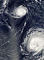
Hurricane Gordon (top) and Hurricane Helene (bottom-right)
-
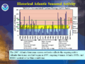
A graph showing averages and statistics for Atlantic hurricane seasons


See also
 In Spanish: Temporada de huracanes en el Atlántico de 2006 para niños
