
Hurricane Florence (2006) facts for kids
| Category 1 hurricane (SSHWS/NWS) | |

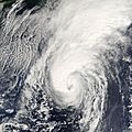
Hurricane Florence approaching Bermuda on September 10.
|
|
| Formed | September 3, 2006 |
|---|---|
| Dissipated | September 13, 2006 |
| Highest winds | 1-minute sustained: 90 mph (150 km/h) |
| Lowest pressure | 974 mbar (hPa); 28.76 inHg |
| Damage | $200,000 (2006 USD) |
| Areas affected | Bermuda, Newfoundland, eastern United States |
| Part of the 2006 Atlantic hurricane season | |
Hurricane Florence was a powerful storm that brought strong winds to Bermuda in September 2006. It was the first hurricane to hit Bermuda with hurricane-force winds since Hurricane Fabian in 2003.
Florence was the seventh tropical storm and the second hurricane of the 2006 Atlantic hurricane season. It started as a tropical wave in the Atlantic Ocean on September 3. At first, the storm struggled to get organized and grew very large. After a few days, it found better conditions and became a hurricane on September 10.
The hurricane passed just west of Bermuda and then moved northeast. By September 13, it changed into an extratropical cyclone, which is a different type of storm.
Hurricane Florence caused wind gusts up to 115 mph (185 km/h) on Bermuda. This led to power outages and some minor damage. Later, as an extratropical storm, Florence brought heavy rains to Newfoundland. It destroyed one house there and caused small damage to others. Luckily, no one died because of Hurricane Florence.
Contents
How Hurricane Florence Formed and Grew

Hurricane Florence began as a tropical wave that moved off the coast of Africa on August 29. Two of these waves combined by September 2, creating a large area of stormy weather over the eastern Atlantic Ocean. This system started to get more organized.
By September 3, it had a clear circulation and enough storm clouds to be called Tropical Depression Six. It was located about halfway between the Lesser Antilles and Africa.
Florence Becomes a Tropical Storm

After forming, the depression had many swirling clouds. However, strong winds high in the atmosphere prevented it from getting stronger right away. Dry air also slowed its development. Forecasters found it hard to locate the exact center of the storm.
The storm moved slowly to the west-northwest. Even though the strongest storm clouds were on the edges, the system slowly became more organized. On September 5, it strengthened into Tropical Storm Florence. At this time, it was about 1120 miles (1800 km) east-northeast of Anguilla.
A Very Large Storm
For three days after becoming a tropical storm, Florence's winds stayed between 40 mph (65 km/h) and 50 mph (85 km/h). This was because Florence was very large. Its wind field stretched 460 miles (745 km) wide.
By September 6, organized cloud swirls became visible, with rainbands forming. Forecasters thought Florence would quickly become a major hurricane. However, it was still hard to find a clear center of circulation.
Florence Becomes a Hurricane

On September 7, storm clouds finally developed over the center of Florence. But the storm did not get stronger, even though it was over warm 84° F (29° C) water with light winds. Its wind field was over 1035 miles (1670 km) across, making it very hard to predict.
By September 8, Florence looked like a stretched-out, shapeless cloud. Later that day, it started to pull together and strengthen as it turned northwest. Early on September 10, an eye began to form in the center. Soon after, Florence became a hurricane. It was about 390 miles (630 km) south of Bermuda.
Weakening and Becoming Extratropical
Hurricane Florence then turned north and northeast. Even though its eyewall was not fully closed, forecasters thought it might become a strong Category 2 hurricane as it neared Bermuda.
On September 10, the hurricane reached its strongest winds of 90 mph (150 km/h). After this, the eyewall weakened, and on September 11, Florence passed about 60 miles (95 km) west of Bermuda with winds of 85 mph (135 km/h). It briefly got a bit stronger again before facing stronger winds higher up and cooler waters.
By September 12, most of the storm clouds disappeared. Florence began to lose its tropical features. On September 13, it changed into an extratropical cyclone. This happened about 485 miles (780 km) south-southwest of Cape Race, Newfoundland.
At first, the storm still had hurricane-force winds. The extratropical storm passed near Cape Race before moving east-northeast. By September 14, its winds weakened. Over the next few days, the storm moved in a large loop southwest of Iceland. Finally, it was absorbed by another storm east of Greenland.
Preparing for the Storm
The government of Bermuda issued a hurricane watch for the island on September 8. This was followed by a tropical storm warning on September 9. On September 10, as Florence became a hurricane, a hurricane warning was put in place.
Officials urged people to get ready for the storm. Many residents bought supplies at local stores and put up storm shutters on their homes. Boat owners moved their boats to safer places. An emergency shelter was also set up on the island.
Before Florence arrived, bus and ferry services were stopped. All schools and government offices were closed on the day the storm hit. The Bermuda International Airport also closed down.
Impact of Hurricane Florence
Hurricane Florence caused strong ocean swells and dangerous surf conditions. These affected the northern Lesser Antilles, U.S. Virgin Islands, Puerto Rico, Hispaniola, and Bermuda. Later, the storm also created strong winds and rough waves along the East Coast of the United States. It also caused strong swells and dangerous rip currents in the Bahamas and Atlantic Canada.
Impact on Bermuda
When Hurricane Florence passed west of Bermuda, it brought very strong winds. Sustained winds reached 82 mph (132 km/h) on St. David's Island. Wind gusts reached 115 mph (185 km/h) in St. George's Parish.
These strong winds knocked down trees and power lines. Over 25,000 homes and businesses lost electricity during the storm. The powerful winds damaged ten houses, with three losing their roofs. Windows were also blown out across the island. A few people were hurt by flying glass, but no one needed hospital care. The island received 1.32 inches (34 mm) of rain.
A possible tornado in Southampton Parish knocked down trees and caused light damage to buildings. At the Bermuda Zoo and Aquarium, two flamingos died from falling branches. During the worst of the storm, police told people to stay inside. However, there were some reports of looting.
The storm caused over $200,000 (2006 USD) in damage on Bermuda. Power was quickly restored to 7,000 homes and businesses within six hours after the storm passed. By the next day, about 3,000 homes still had no electricity. The storm also damaged the causeway between St. David's Island and Hamilton Parish, temporarily limiting traffic.
Impact on Newfoundland
As an extratropical storm over Newfoundland, Florence brought strong winds that reached 101 mph (163 km/h). It also caused moderate rainfall, up to 2.6 inches (67 mm). Some flooding and power outages were reported, but they were not widespread.
The storm caused flight delays at St. John's International Airport. It also affected the ferry service between Newfoundland and Cape Breton Island in eastern Nova Scotia. Strong winds destroyed a house in the small Newfoundland village of Francois. The people of Francois agreed to help rebuild the house, and the family stayed in a summer home for a while. The winds also damaged shingles and sides of homes. Strong waves damaged roads and boats along the Burin Peninsula.
Images for kids
-
Hurricane Florence over Bermuda on September 11
-
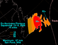
Rainfall totals for Florence in Newfoundland (in metric units) Imperial units


Related pages
- NHC's archive on Hurricane Florence
- HPC's rainfall page for Florence
- CHC's archive on Hurricane Florence
|
Tropical cyclones of the 2006 Atlantic hurricane season |
||||||||||||||||||||||||||
|
|
|||||||||||||||||||||||||
|
|
||||||||||||||||||||||||||
See also
 In Spanish: Huracán Florence (2006) para niños
