
Tropical Storm Chris (2006) facts for kids
| Tropical storm (SSHWS/NWS) | |

Tropical Storm Chris on August 2, 2006.
|
|
| Formed | July 31, 2006 |
|---|---|
| Dissipated | August 5, 2006 |
| Highest winds | 1-minute sustained: 65 mph (100 km/h) |
| Lowest pressure | 1001 mbar (hPa); 29.56 inHg |
| Damage | Minimal |
| Areas affected | Leeward Islands, Puerto Rico, Turks & Caicos Islands, Hispaniola, Bahamas, eastern Cuba |
| Part of the 2006 Atlantic hurricane season | |
Tropical Storm Chris was the fourth named storm of the 2006 Atlantic hurricane season. It formed on July 31, 2006, in the Atlantic Ocean. This storm started east of the Leeward Islands.
Chris moved generally northwest, staying near the northern Caribbean islands. It was a short-lived storm. Chris reached its strongest point on August 2. At that time, its winds were about 65 mph (100 km/h). This was when it was north of St. Martin. The storm slowly got weaker. It finally disappeared on August 5, near eastern Cuba.
Overall, Chris caused very little damage. It brought moderate amounts of rainfall along its path. Luckily, no deaths were reported because of the storm.
Contents
How Tropical Storm Chris Formed and Traveled

A tropical wave started moving west from Africa on July 27. At first, it had a lot of stormy clouds. But dry air made these clouds disappear for a bit. The wind pattern stayed clear as it moved west. Two days later, more stormy clouds appeared.
On July 31, a special buoy recorded a wind change. This showed that a small area of low pressure had formed. The storm clouds quickly got more organized. The system then became Tropical Depression Three on August 1. It was about 235 miles (375 km) east-southeast of Barbuda.
Experts first thought strong winds high up would stop it from getting stronger. They thought it would disappear in three days. But the depression kept getting more organized. Stormy clouds kept forming near its center. Six hours after forming, it became Tropical Storm Chris.
The stormy clouds slowly covered the whole system. By late on August 1, Chris had winds of 60 mph (95 km/h). It passed about 50 miles (80 km) north of the northern Leeward Islands. Chris continued to improve and become more even. A small eye feature formed high up on August 2.
The storm reached its strongest point with 65 mph (100 km/h) winds. This was when it was 120 miles (195 km) east of St. Thomas. Even though it was predicted to become a hurricane, strong winds high up broke apart its center. Chris then started to weaken.

By early August 3, strong winds high above Chris pushed the stormy clouds away. A high-pressure area to its north turned the storm west. This also moved it into an area of drier air. By midday on August 3, the center of the storm had no clouds for 85 miles (135 km). The deeper stormy clouds spread over Puerto Rico and Hispaniola.
Later on August 3, stormy clouds formed over the center again. But strong winds kept weakening Chris. It became a tropical depression again on August 4. Experts thought it might get stronger in the Gulf of Mexico. However, the clouds remained very few. Chris turned into a leftover low-pressure area late on August 4. It finally disappeared near Havana, Cuba, on August 6.
Getting Ready for Tropical Storm Chris

When Tropical Depression Three first formed, many islands issued warnings. These included Antigua and Barbuda, Anguilla, Saint Kitts and Nevis, and the British Virgin Islands. They all put out Tropical Storm Warnings. When it became Tropical Storm Chris, warnings were also given for Saba, Sint Eustatius, Saint-Barthélemy, and Saint Martin.
Three Royal Caribbean cruise ships changed their routes to avoid the storm. FEMA worked with local emergency teams. They checked if hospitals, shelters, and sandbags were needed in the United States Virgin Islands. In St. Thomas, all jet flights were canceled. Ferry service from Saint Martin to Anguilla was also stopped for a short time.
Saint Martin officials told people to secure loose items. They also told people near the coast to prepare for high waves. Construction sites were asked to secure their equipment. A warning was also given for small boats near Saint Martin due to strong waves.
On August 1, officials in Puerto Rico issued a tropical storm warning. The next day, about 600 tourists left the islands of Vieques and Culebra. People in Puerto Rico got ready by buying supplies and filling up gas. On August 2, the government of the Bahamas issued a Hurricane Watch. This was for the Turks and Caicos Islands and other nearby islands. Officials told people to get hurricane supplies. Boat owners in Staniel Cay secured their boats.
In New Orleans, officials prepared for a possible evacuation. This was in case Chris entered the Gulf of Mexico as a hurricane. The plan was to move everyone out of the city. This was to avoid problems like those during Hurricane Katrina a year before.
What Happened When Chris Hit
Damage from Tropical Storm Chris was small. It mainly caused local flooding.
St. Thomas had short periods of heavy rain. It received over 3 inches (75 mm) of rain. Anguilla reported light rain and wind gusts up to 21 mph (34 km/h). In St. John, wind gusts reached 23 mph (37 km/h). It also had nearly 3 inches (75 mm) of rain.
In San Juan, Puerto Rico, the storm caused very little wind or rain. Storm clouds separate from the center brought 30 mph (48 km/h) wind gusts. They also brought over 1.3 inches (33 mm) of rain in Culebra. The most rain fell in Fajardo, with 3.09 inches (78 mm). This rain caused the Fajardo River to overflow. The overflowing water temporarily closed a highway in the northeast part of the island.
Rainfall reached up to 2 inches (50 mm) in parts of Hispaniola. It also rained in the Turks and Caicos, the Bahamas, and eastern Cuba. Some mountainous areas got 4 inches (100 mm) of rain. In Santo Domingo in the Dominican Republic, heavy rain caused serious flooding. Las Américas reported 5.01 inches (127 mm) of rain from Chris.
Some people were left without homes for a short time. This was because floodwaters entered their houses. The flooding made many roads impassable near the capital city. It also caused landslides. The flooding covered rice fields in the northeast part of the country. The National Office of Meteorology warned people in low-lying areas about floods. Despite the flooding, the overall damage was minor. No one died because of Tropical Storm Chris.
Related Pages
|
Tropical cyclones of the 2006 Atlantic hurricane season |
||||||||||||||||||||||||||
|
|
|||||||||||||||||||||||||
|
|
||||||||||||||||||||||||||
Images for kids
-
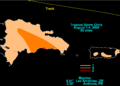
Rainfall totals from Tropical Storm Chris in Puerto Rico and the Dominican Republic

See also
 In Spanish: Tormenta tropical Chris (2006) para niños
