Hurricane Isaac (2006) facts for kids
| Category 1 hurricane (SSHWS/NWS) | |

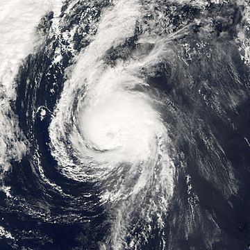
Hurricane Isaac near peak intensity.
|
|
| Formed | September 27, 2006 |
|---|---|
| Dissipated | October 3, 2006 |
| Highest winds | 1-minute sustained: 85 mph (140 km/h) |
| Lowest pressure | 985 mbar (hPa); 29.09 inHg |
| Damage | Minimal |
| Areas affected | Newfoundland |
| Part of the 2006 Atlantic hurricane season | |
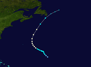
Hurricane Isaac was the last big storm of the 2006 Atlantic hurricane season. It became a strong Category 1 hurricane just before hitting Newfoundland. There, it brought strong winds, like a tropical storm. Isaac followed the same path as three earlier storms: Florence, Gordon, and Helene. It started in the middle of the North Atlantic Ocean and moved east, towards Europe.
Hurricane Isaac began forming off the coast of Africa on September 18. Strong winds high up in the atmosphere made it hard for Isaac to get stronger at first. Also, the ocean water was a bit cool because of Hurricanes Gordon and Helene that passed before.
Isaac became a tropical storm on September 28. It then moved into an area with weaker high-level winds. This allowed it to grow into a hurricane with winds of 85 mph (137 km/h).
On October 1, Isaac turned northeast and hit Newfoundland as a tropical storm. Two days later, it joined with another weather system off the east coast of the United States. This combined system was expected to move towards Greenland and Great Britain. Isaac brought up to 25 mm (1 in) of rain to Newfoundland. Luckily, no one was hurt, and there was no damage reported. Isaac was the second storm to affect Newfoundland that season, after Hurricane Florence.
How Hurricane Isaac Formed and Grew
Isaac started as a tropical wave that moved away from Africa on September 18. A tropical wave is like a ripple in the atmosphere. On September 23, an area of stormy weather began to mix with this tropical wave. This caused more deep clouds and thunderstorms to form.
Weather experts watched the storm closely. They thought it would become a hurricane with winds of 88 knots (150 km/h). But the storm took a while to get organized. The National Hurricane Center (NHC) first thought it might become a tropical depression, but then decided it wasn't strong enough yet.
Three days later, on September 27, the NHC announced that the ninth tropical depression of the Atlantic season had formed. This means it was a low-pressure system with organized thunderstorms.
The depression became Tropical Storm Isaac on September 28. This was just twelve hours after it officially formed. At first, the storm didn't get much stronger. This was because it was over cooler ocean waters. These waters had been stirred up by Hurricanes Gordon and Helene earlier.
The next day, Isaac moved west-northwest. It started to gain some subtropical features, meaning it had traits of both tropical and non-tropical storms. As it moved away from the cold water, the strong winds high up in the atmosphere weakened. This allowed Isaac to get stronger.
The weather conditions remained good for the storm to grow. Isaac officially became a hurricane on September 30. It continued to get a little stronger near Bermuda the next day. It reached its strongest point with winds of 85 mph (135 km/h). Its lowest central pressure was 985 mbar. Soon after, Isaac's winds dropped slightly to 80 mph (130 km/h).
As Isaac got closer to Newfoundland on October 1, it moved over cooler waters. This caused it to weaken into a tropical storm by October 2. Isaac made landfall on the Avalon Peninsula as a weak tropical storm that same day. It still had the structure of a tropical storm. Soon after, Isaac changed into an extratropical storm. On October 3, it merged with a larger weather system off the Avalon Peninsula.
Safety Measures and Impact
On October 1, a tropical storm watch was issued for the Avalon Peninsula. This means tropical storm conditions were possible. The next day, this watch was upgraded to a tropical storm warning. This meant tropical storm conditions were expected.
Another watch was put out for the Burin and Bonavista peninsulas, but it was quickly removed. By October 2, all tropical cyclone watches and warnings were canceled. People were told to expect heavy rain and strong winds. Because of this, rainfall warnings were given for parts of southern Newfoundland. Wind and gale advisories were also issued for the Atlantic Ocean.
On October 2, a ship named the Elektra reported winds of 52 mph (84 km/h). This ship was about 170 mi (270 km) east of the storm's center. Other ships, many buoys, and some oil platforms also recorded strong winds. Waves off the coast reached about 16 ft (4.9 m) high.
Isaac did not cause much trouble on land. No people were killed, and there was no major damage. However, some parts of the Avalon Peninsula did experience tropical storm conditions. At Cape Race, steady winds reached 46 mph (74 km/h). Wind gusts were as high as 60 mph (97 km/h). The strongest winds stayed out at sea. Since the storm was moving very fast, it did not drop a lot of rain. Most places received less than 1 in (25 mm) of rain.
Related pages
- The NHC's archive on Hurricane Isaac.
- The CHC's archive on Hurricane Isaac .
 | Aurelia Browder |
 | Nannie Helen Burroughs |
 | Michelle Alexander |


