
Image: The Mid-Atlantic States

Size of this preview: 800 × 520 pixels. Other resolutions: 320 × 208 pixels | 1,513 × 983 pixels.
Original image (1,513 × 983 pixels, file size: 43 KB, MIME type: image/png)
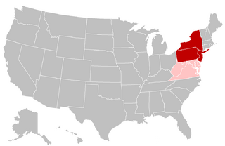
Description: Map of the Mid-Atlantic United States. Red shading indicates the states most commonly defined as the Mid-Atlantic in their entirety (i.e. the southern portion of the Northeast) by public sector agencies and private organizations. Pink shading indicates states that are grouped in the region less frequently.
Title: The Mid-Atlantic States
Credit: Modified from: File:BlankMap-USA-states.PNG
Author: Grayshi, Roke, Maher-shalal-hashbaz
Usage Terms: Creative Commons Attribution-Share Alike 3.0
License: CC BY-SA 3.0
License Link: https://creativecommons.org/licenses/by-sa/3.0
Attribution Required?: Yes
Image usage
The following page links to this image:

All content from Kiddle encyclopedia articles (including the article images and facts) can be freely used under Attribution-ShareAlike license, unless stated otherwise.