
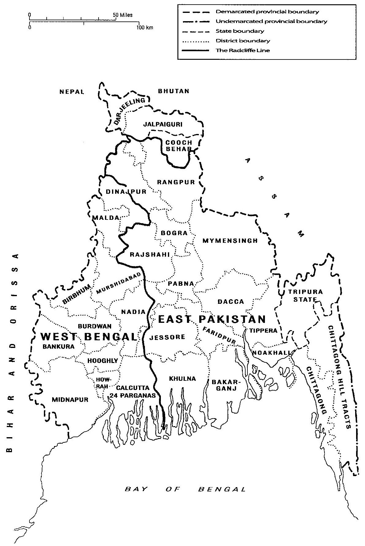
Image: The Radcliffe Line between West and East Bengal, 1947
Description: On 17 August 1947, Radcliffe’s Award on the boundaries of Bengal was announced. It contained few surprises. It divided Bengal into West Bengal, which covered 28,000 square miles and had a population of just over 21 million people, and East Bengal, a territory of 49,000 square miles with a population of 39 million people. Over 5 million Muslims were left in West Bengal and about 11 million Hindus found themselves stranded in the eastern wing of Pakistan. In an unconscious irony, Radcliffe’s line bore a certain resemblance to Curzon’s line of 1905 (compare with map https://commons.wikimedia.org/wiki/File:Curzon’s_Partition_of_Bengal,_1905–1912.jpg). Significantly, Radcliffe’s Award accepted the two ‘cardinal principles’ that had informed the Congress Plan: first that the two parts into which Bengal was to be divided should contain respectively as many of the total Muslim and Hindu populations of Bengal as possible and, secondly, that ‘the ratio of Muslims to Hindu in one zone must be as nearly equal as possible to the ratio of Hindu to Muslims in the other’. (Source: Memorandum on the Partition of Bengal presented on behalf of the Indian National Congress before the Bengal Boundary Commission, and ‘Report of the non-Muslim members’, PP VI, Page 30) The two states created by Radcliffe’s Award in fact contained communities of Hindus and Muslims in almost exactly the same but inverse ratios. The Award gave East Bengal a population which was 71 percent Muslim and West Bengal a population which was 70.8 percent Hindu. Admittedly, West Bengal got a few more of the Muslims of united Bengal than the Congress would have liked it to contain: had the Congress Plan been followed in its entirety, the figures would have been 77 percent and 68 percent respectively. (Source: Memorandum on the Partition of Bengal presented on behalf of the Indian National Congress before the Bengal Boundary Commission, and ‘Report of the non-Muslim members’, Page 6) But otherwise what Radcliffe awarded was almost exactly what the Congress wanted. Radcliffe’s Award accepted the Congress proposition that the unit for partition should be the thana or police station, being the smallest administrative entity for which there were published census figures. (Source: Memorandum on the Partition of Bengal presented on behalf of the Indian National Congress before the Bengal Boundary Commission, and ‘Report of the non-Muslim members’, Page 27) It also went along with the Congress claim, which Atul Gupta had been at pains to stress, about the importance for West Bengal to have the Murshidabad and Nadia river systems if the Hooghly was to survive as an artery of the new state. The Award gave the whole of Murshidabad to West Bengal. On the other hand, Khulna, except for those parts of the district which were to the east of the river Mathabhanga, went to Pakistan, the Award taking its cue on this point also from the Congress’s tacit willingness to exchange Hindu-majority Khulna for Muslim-majority Murshidabad. With Khulna, those parts of Faridpur and Bakarganj which were contiguous to Khulna also went to Pakistan. Calcutta, which everyone agreed was the political and economic heart of the province, of course went to West Bengal. It also got the tea producing districts of Darjeeling and Jalpaiguri, (Source ‘The Schedule’, Sir Cyril Radcliffe’s Award, 12 August 1947, in PP VI, Page 119.) except five thanas in Jalpaiguri in which Muslims were in a majority. These were in the Boda-Debiganj-Panchagarh area contiguous to Rangpur. In giving these northern districts to West Bengal despite the fact that they were not contiguous to the rest of the province, Radcliffe rejected the Muslim League’s contention that ‘contiguity’ within Bengal had to be the overriding principle of the Award. However, by way of compensation, the Chittagong Hill Tracts, which had a non-Muslim and mainly tribal majority, and which were contiguous to Assam but not to West Bengal, went to East Pakistan, much to the chagrin of the Congress high command, which had given its followers in Chittagong assurances (it is hard to tell on what conceivable basis) that the Tracts would come to India. The Tracts had never been claimed for West Bengal. So this fascinating little vignette, a sub-plot in the extraordinary tale of the Radcliffe Award, should be discussed, but in another place. In principle and in practice the Radcliffe Award looked remarkably like the Congress Plan. One point, however, in which the Award failed to follow the Congress Plan was the Congress’s insistence that its new boundaries must run in a continuous and unbroken line. (Source: Point Two of the ‘Guiding Rules’ set out in Memorandum on the partition of Bengal presented on behalf of the Indian National Congress before the Bengal Boundary Commission) Radcliffe did not give West Bengal the continuous boundary which would have required him to carve out a corridor connecting the two north Bengal districts with the rest of the new province. As it was, the Award left parts of West Bengal separated from each other by land which went to Pakistan or by land belonging to other Indian states. Justifying a corridor for West Bengal after Nehru had denounced Jinnah’s demand for a corridor to link West and East Pakistan as ‘fantastic and absurd’ would no doubt have been a trifle difficult. (Source: Allen Campbell-Johnson, Mission with Mountbatten, London, 1985, Page 94–6) West Bengal did not get a direct territorial link with its northern districts until 1956, when the States Reorganisation Committee gave it a narrow strip of Bihar, which at last joined together the two parts of the state which had been unconnected since August 1947. (Source: Report of the States Reorganisation Commission, New Delhi, 1955, Page 174–80)
Title: The Radcliffe Line between West and East Bengal, 1947
Credit: Own work
Author: RNRCTG
Usage Terms: Creative Commons Attribution-Share Alike 4.0
License: CC BY-SA 4.0
License Link: https://creativecommons.org/licenses/by-sa/4.0
Attribution Required?: Yes
Image usage
The following page links to this image:
