
Image: Thompson Creek (San Jose, California)

Size of this preview: 199 × 598 pixels. Other resolutions: 80 × 240 pixels | 868 × 2,608 pixels.
Original image (868 × 2,608 pixels, file size: 895 KB, MIME type: image/jpeg)
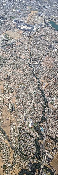
Description: Aerial view of Thompson Creek in San Jose, California. At Raging Waters at the upper right it becomes Lower Silver Creek, a tributary to Coyote Creek; Silver Creek is sometimes labeled Miguelita Creek near its confluence with Coyote Creek. The Yerba Buena Rd. at San Felipe Rd. intersection at Evergreen Park is visible at bottom. Reid–Hillview Airport and Eastridge Center are visible near top center.
Title: Thompson Creek (San Jose, California)
Credit: Own work
Author: Dicklyon
Usage Terms: Creative Commons Attribution-Share Alike 4.0
License: CC BY-SA 4.0
License Link: https://creativecommons.org/licenses/by-sa/4.0
Attribution Required?: Yes
Image usage
The following page links to this image:

All content from Kiddle encyclopedia articles (including the article images and facts) can be freely used under Attribution-ShareAlike license, unless stated otherwise.
.jpg)