
Image: Tog-og-metro-i-hovedstadsomraadet

Size of this preview: 500 × 599 pixels. Other resolutions: 200 × 240 pixels | 5,000 × 5,991 pixels.
Original image (5,000 × 5,991 pixels, file size: 1.6 MB, MIME type: image/png)
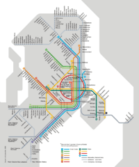
Description: Map of the city's rail networks. Metro, S-train, Regional trains and Local trains.
Title: Tog-og-metro-i-hovedstadsomraadet
Credit: https://dinoffentligetransport.dk/media/2440/tog-og-metro-i-hovedstadsomraadet_022021.pdf
Author: DOT (Din Offentlige transport)
Usage Terms: Creative Commons Attribution-Share Alike 4.0
License: CC BY-SA 4.0
License Link: https://creativecommons.org/licenses/by-sa/4.0
Attribution Required?: Yes
Image usage
The following page links to this image:

All content from Kiddle encyclopedia articles (including the article images and facts) can be freely used under Attribution-ShareAlike license, unless stated otherwise.