
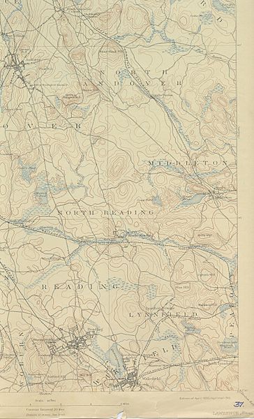
Image: USGS Lawrence, MA-NH 15 minute Quadrangle SE (1893)

Description: Southeastern corner (quarter???) of the Lawrence, Massachusetts 15 minute quadrangle USGS map, (Full map shows lands north into portions of New Hampshire). 1893 version. • 1893 surveyed map devoid of modern road networks shows the wetlands origination of the Skug River and {Boston Brook, both left bank tributaries of the Ipswich River in Essex County, Massachusetts through the suburbs of Boston's North Shore. • Various railroads and the fundamental road network before automobile clubs are evident. Railway stations are mentioned showing the hearts of today's more sprawling suburbs. • Top of map ends cutting off North Andover Main Street district and near South Lawrence border and the Junction of Interstate I-495 with MA 114.
Title: USGS Lawrence, MA-NH 15 minute Quadrangle SE (1893)
Credit: United States Geographic Survey, US Department of the Interior.
Author: United States Geographic Survey, US Department of the Interior.
Permission: Public domain - original work of the US Federal Government
Usage Terms: Public domain
License: Public domain
Attribution Required?: No
Image usage
The following 2 pages link to this image:

.jpg)