
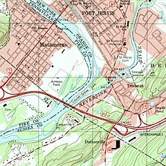
Image: USGS Port Jervis South (1995), NJ-NY-PA Tri-States Monument detail

Size of this preview: 600 × 600 pixels. Other resolutions: 240 × 240 pixels | 1,638 × 1,638 pixels.
Original image (1,638 × 1,638 pixels, file size: 3.72 MB, MIME type: image/jpeg)
Description: Detail of the USGS topographic map for Port Jervis South showing the area around the Tri-States Monument marking the boundary of the states of New Jersey, New York, and Pennsylvania.
Title: USGS Port Jervis South (1995), NJ-NY-PA Tri-States Monument detail
Credit: https://prd-tnm.s3.amazonaws.com/StagedProducts/Maps/HistoricalTopo/PDF/NY/24000/NY_Port%20Jervis%20South_136826_1995_24000_geo.pdf
Author: USGS
Usage Terms: Public domain
License: Public domain
Attribution Required?: No
Image usage
The following page links to this image:

All content from Kiddle encyclopedia articles (including the article images and facts) can be freely used under Attribution-ShareAlike license, unless stated otherwise.
,_NJ-NY-PA_Tri-States_Monument_detail.jpg)