
Image: USPostRoadMap1804

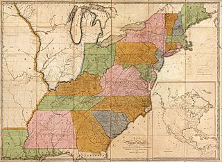
Description: Map of the United States : exhibiting the post-roads, the situations, connexions & distances of the post-offices, stage roads, counties & principal rivers; Scale [ca. 1:1,940,000]; [5th ed.] Philadelphia : Made and sold by Caldcleugh and Thomas, [1804] Relief shown pictorially. Also shows townships in parts of Maine, New York, and Indiana Territory. Illinois (not named) is shown as part of Indiana Territory. Slipcase title and publisher's statement from printed labels affixed to slipcase. Earliest state of the 5th ed. Prime meridian: Washington D.C. "Entered according to the Act of Congress the 2nd day of June 1804 by Abraham Bradley Jun'r of the District of Columbia." Sectioned (to 36 panels) and mounted on cloth backing to fold to 23 x 17 cm. Imperfect: Lightly foxed, worm-holed in margin, slip-case flattened. Includes notes in map area and inset "Map of North America" (scale ca. 1:17,000,000).
Title: USPostRoadMap1804
Credit: Library of Congress digital collection: http://hdl.loc.gov/loc.gmd/g3700.ct002344
Author: Abraham Bradley, Jr.
Usage Terms: Public domain
License: Public domain
Attribution Required?: No
Image usage
The following page links to this image:
