
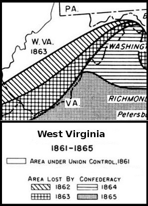
Image: Union and Confederate territorial losses in West Virginia 1861-1865
No higher resolution available.
Union_and_Confederate_territorial_losses_in_West_Virginia_1861-1865.jpg (296 × 410 pixels, file size: 81 KB, MIME type: image/jpeg)
Description: The map was created by the US Army for a history of the American Civil War and it has been reduced to show only the section of Virginia that became the state of West Virginia in 1863.
Title: Union and Confederate territorial losses in West Virginia 1861-1865
Credit: https://history.army.mil/books/AMH/AMH-10.htm
Author: AnonymousUnknown author
Usage Terms: Public domain
License: Public domain
Attribution Required?: No
Image usage
The following page links to this image:

All content from Kiddle encyclopedia articles (including the article images and facts) can be freely used under Attribution-ShareAlike license, unless stated otherwise.