
Image: United States 1861-01-1861-02-04

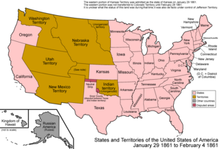
Description: Map of the states and territories of the United States as it was from January 1861 to February 4 1861. On January 29 1861, the eastern portion of Kansas Territory was admitted as the state of Kansas; the western portion seems to have had no official definition for roughly a month, as it was not transferred to Colorado Territory until February 28 1861. During this period, it was de facto under the control of the self-proclaimed Territory of Jefferson. On February 4 1861, the Confederate States of America was created. Several states had seceded from the union on dates prior to this, and joined the CSA at different dates. To simplify the map, only the proclamation of the CSA is noted here.
Title: United States 1861-01-1861-02-04
Credit: Own work
Author: Made by User:Golbez.
Permission: Own work, attribution required (Multi-license with GFDL and Creative Commons CC-BY 2.5)
Usage Terms: Creative Commons Attribution 2.5
License: CC BY 2.5
License Link: https://creativecommons.org/licenses/by/2.5
Attribution Required?: Yes
Image usage
The following page links to this image:
