
List of territorial claims and designations in Colorado facts for kids

The land that is now the State of Colorado has changed hands many times. Different groups have claimed it throughout history. The first people, called Paleoamericans, arrived around 11,500 BCE. Some new studies even suggest they might have visited much earlier. At least nine Native American nations have called this area home.
Europeans, like the Spanish, might have explored the region as early as 1540. However, the first European fort was not built until 1819. The first European town was not started until 1851. This was mainly because the Ute people resisted their arrival.
Over time, Spain, France, Mexico, and the Republic of Texas all claimed parts of this land. The United States first claimed an eastern part of the future state in 1803. This was part of the Louisiana Purchase. The U.S. gave up the land south and west of the Arkansas River to the Spanish Empire in 1821 with the Adams–Onís Treaty.
The United States finally owned the entire region after the Mexican–American War. This happened with the Treaty of Guadalupe Hidalgo in 1848. The U.S. then created the Colorado Territory in 1861. This was after the Pike's Peak Gold Rush brought many people to the area.
The Colorado Territory supported the Union during the American Civil War. This was true even though many of its early settlers came from states that allowed slavery. Colorado officially joined the Union as a state in 1876. This was the 100th birthday of the United States.
Contents
First Peoples of Colorado
Many different Native American groups have lived in the area that is now Colorado. Here are some of them:


- Paleoamericans (very early peoples)
- Pre-Clovis culture
- Clovis culture
- Folsom culture
- Plano cultures
- Archaic Period (ancient times)
- Apex complex
- Archaic–Early Basketmaker Era
- Mount Albion complex
- Post-Archaic Period (later ancient times)
- Ancestral Puebloans (ancient farming people)
- Native American Nations (groups living in the area more recently)
- Apache Nation
- Arapaho Nation
- Northern Arapaho
- Southern Arapaho
- Cheyenne Nation
- Comanche Nation
- Kiowa Nation
- Navajo Nation
- Pawnee Nation
- Shoshone Nation
- Ute Nation
- Capote Ute band: Lived in the upper Rio Grande and San Luis Valley.
- Mouache Ute band: Lived on the eastern side of the Southern Rocky Mountains.
- Parianuche Ute band (later White River band): Lived in the upper Colorado River valley.
- Tabeguache Ute band (later Uncompahgre band): Lived in the Gunnison River and Uncompahgre River valleys.
- Weeminuche Ute band: Lived in the San Juan River basin.
- Yamparica Ute band (later White River band): Lived in northwestern Colorado.
- Uintah Ute bands: Lived in eastern Utah.
Early European Claims
Here's how European countries first claimed parts of the "New World," including areas that would become Colorado:

- Christopher Columbus's First Voyage (1492-1493)
- Christopher Columbus led the first southern European trip to the Americas. He thought he had reached islands near Japan. This journey became the reason for Spain to claim all of the Americas.

- Pope Alexander VI's Inter Caetera (1493)
- After Columbus's first trip, Pope Alexander VI issued a special order called a papal bull. This order divided the non-Christian world into two halves. The eastern half was for Portugal, and the western half (including most of the Americas) was for Spain. This was for exploration, conquest, and spreading Christianity.
- The Treaty of Tordesillas (1494)
- This treaty was signed by Portugal and the Spanish Empire. It moved the dividing line further west than the Pope's original line. This gave Portugal more of Brazil, but Spain still got most of the Americas. Pope Julius II approved this treaty later in 1506.
- Vasco Núñez de Balboa Claims the Pacific Ocean (1513)
- Vasco Núñez de Balboa and his group were the first Europeans to reach the eastern Pacific Ocean. He claimed the Pacific Ocean and all the land next to it for the Queen of Castile. This claim included all of the Americas west of the Continental Divide.
Spanish Empire (1492-1821)
The Spanish Empire claimed parts of what is now Colorado for many years:
.jpg)
- Columbus Claims San Salvador (1492)
- On October 12, 1492, Columbus landed on the Taíno island of Guanahani in the Bahamas. He renamed it San Salvador and claimed it for the King and Queen of Spain. This claim was the start of the Spanish Empire.

- Hernán Cortés Conquers the Aztecs (1521)
- Hernán Cortés defeated the Aztec Empire and took their capital, Tenochtitlán. He renamed it México City and created New Spain. This was a huge Spanish colony that included much of North America.
- Francisco Vázquez de Coronado's Expedition (1540)
- Francisco Vázquez de Coronado led a large trip north from New Spain. He was looking for the legendary Seven Cities of Gold. His journey explored areas that are now Arizona, New Mexico, Texas, Oklahoma, Kansas, and possibly Colorado.

- Juan de Oñate Establishes New Mexico (1598)
- Juan de Oñate started the Spanish colony of Santa Fe de Nuevo Méjico in 1598. This colony was very large. It covered all of present-day New Mexico and parts of Arizona, Utah, Colorado, Wyoming, Nebraska, Kansas, Oklahoma, Texas, and the Mexican state of Chihuahua.
- The Adams–Onís Treaty (1819-1821)
- On February 22, 1819, the United States and the Spanish Empire signed a treaty. It was called the Treaty of Amity, Settlement, and Limits. It officially took effect two years later, in 1821. Spain gave Florida and other lands to the U.S. The U.S. gave up some land in the southwestern Mississippi River basin to Spain.
- The Treaty of Córdoba (1821)
- This treaty was signed on August 24, 1821. With it, the Spanish Empire recognized that the Mexican Empire was now an independent country. This meant Mexico took over Spain's claims in the region.
Kingdom of France (1682-1764)
The Kingdom of France also claimed a large area, the Mississippi River basin:

- La Salle Claims Louisiana (1682)
- La Salle traveled down the Mississippi River to its end. On April 9, 1682, he claimed the entire Mississippi River basin for the King of France. This huge area was called La Louisiane. This claim did not consider the Native Americans already living there. Spain argued that this claim went into their territory of New Mexico and Texas.
- The Treaty of Fontainebleau (1762-1764)
- During the Seven Years' War, France was worried about losing all its lands in North America. So, on November 23, 1762, King Louis XV of France secretly gave La Louisiane to his cousin, King Carlos III of Spain. This was not announced until September 30, 1764. Even though Spain now owned it, the area remained mostly French-speaking.
Kingdom of Spain (1762-1803)
Spain's claims in the Mississippi River basin changed again:


- The Treaty of Fontainebleau (1762-1764)
- As mentioned, King Louis XV of France secretly transferred La Louisiane to King Carlos III of Spain. This made Spain the owner of this vast territory.
- The Third Treaty of San Ildefonso (1800)
- French First Consul Napoléon Bonaparte wanted France to have a presence in the Americas again. He pressured King Carlos IV of Spain to secretly agree to give La Luisiana back to France. In return, France gave up its claims in Tuscany.
- The Treaty of Aranjuez (1801)
- This treaty between France and Spain set the rules for giving La Louisiane back to France.
- Spain Transfers Louisiana to France (1803)
- On November 30, 1803, in a ceremony in New Orleans, Spain officially gave control of La Luisiana to France. This was done to prepare for the Louisiana Purchase, where France would sell the land to the United States. A similar ceremony happened in St. Louis later.
French Republic (1800-1803)
The French Republic briefly claimed the Mississippi River basin:

- The Third Treaty of San Ildefonso (1800)
- Napoléon Bonaparte arranged for Spain to give La Luisiana back to France. He wanted to rebuild France's power in the Americas.
- The Treaty of Aranjuez (1801)
- This treaty finalized the return of La Louisiane from Spain to France.
- The Louisiana Purchase (1803)
- U.S. President Thomas Jefferson wanted to buy the port of New Orleans to ensure American ships could use the Mississippi River. Napoléon Bonaparte surprised him by offering to sell the entire territory of La Louisiane. The U.S. agreed to pay $15 million, and the treaty was signed on April 30, 1803.
- Spain Transfers Louisiana to France (1803)
- As mentioned before, Spain officially handed over control of La Luisiana to France in New Orleans on November 30, 1803. This was a quick step before France sold it to the U.S.
- France Transfers Louisiana to the United States (1803)
- Just 20 days after getting it from Spain, France transferred control of La Louisiane to the United States. This happened in New Orleans on December 20, 1803. A similar ceremony took place in St. Louis on March 10, 1804.
Mexico (1821-1848)
After gaining independence, Mexico claimed the lands south and west of the Adams–Onís border:


- The Treaty of Córdoba (1821)
- This treaty, signed on August 24, 1821, meant that Spain recognized the independence of the Mexican Empire. Mexico then took over Spain's claims in the region.
- The Treaty of Limits (1828-1832)
- In 1828, the United States and Mexico signed a treaty confirming the border set by the Adams–Onís Treaty. This treaty officially took effect in 1832.
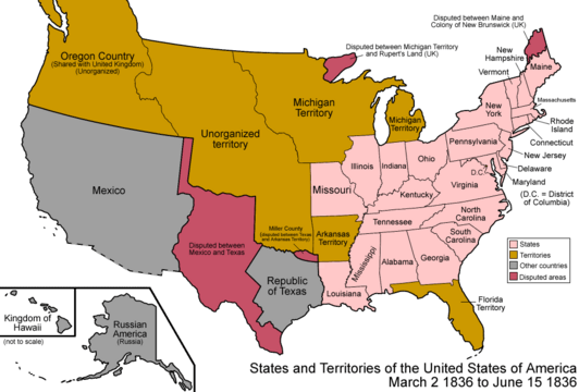
- The Republic of Texas Declares Independence (1836)
- In 1829, Mexico banned slavery. Many American settlers in the Mexican state of Coahuila y Tejas owned slaves. On March 2, 1836, these settlers declared their independence as the Republic of Texas. Mexico refused to accept this, but the United States recognized Texas in 1837.
- The U.S. Annexes Texas (1845)
- On December 29, 1845, U.S. President James K. Polk signed a resolution to make Texas a U.S. state. The U.S. then took on Texas's land claims. Mexico said this was a violation of the earlier treaty. This disagreement led to the Mexican–American War.
- The U.S. Declares War on Mexico (1846)
- On May 13, 1846, President Polk declared war on Mexico. The Mexican–American War lasted until 1848.
- U.S. Army Seizes Santa Fe (1846)
- The U.S. Army of the West, led by General Stephen Kearny, captured Santa Fe, the capital of Nuevo México. They met little resistance. General Kearny became the military governor of New Mexico.
- The Treaty of Guadalupe Hidalgo (1848)
- On February 2, 1848, the United States and Mexico signed this treaty. It officially ended the Mexican–American War on May 30, 1848. Mexico gave up a huge amount of its northern territory to the United States. This land became known as the Mexican Cession.
Republic of Texas (1836-1845)
The Republic of Texas had its own land claims between the Rio Grande and the Adams–Onís border:

- Texas Declares Independence (1836)
- On March 2, 1836, American settlers in Texas declared independence from Mexico. They formed the Republic of Texas. Mexico did not recognize this, but the U.S. did. The Republic of Texas claimed a large area. Its western border was the Rio Grande and then north along a specific line. This claim included half of the Mexican province of Santa Fe de Nuevo México, even though Texas never really controlled that far west.
- The U.S. Annexes Texas (1845)
- On December 29, 1845, the United States officially made Texas a state. The U.S. then took on all of Texas's land claims. Mexico saw this as a reason for war, which led to the Mexican–American War.
United States (1803 to Present)
Here's how the land that is now Colorado became part of the United States:

- The Louisiana Purchase (1803)
- On April 30, 1803, the United States bought the huge territory of La Louisiane from France for $15 million. This greatly expanded the U.S. The U.S. Senate approved the treaty on October 20, 1803.

- France Transfers Louisiana to the U.S. (1803)
- On December 20, 1803, France officially handed over Louisiana to the U.S. in New Orleans. This vast area was at first "unorganized territory" under military control. It was later divided into the Territory of Orleans and the District of Louisiana.
- Creation of the District of Louisiana (1804)
- On October 1, 1804, the U.S. created the District of Louisiana from the northern part of the Louisiana Purchase. This district was governed by the Indiana Territory for a short time.
- Creation of the Territory of Louisiana (1805)
- On July 4, 1805, the District of Louisiana was reorganized and became the Louisiana Territory. This territory would later be renamed the Missouri Territory.
.jpg)
- Creation of the Missouri Territory (1812)
- On June 4, 1812, the Louisiana Territory was renamed the Missouri Territory. Its northern border with British lands was changed in 1818. A southern part of the territory became the Arkansas Territory in 1819. The Adams–Onís Treaty in 1821 also reduced its southwestern size.
- The Adams–Onís Treaty (1819-1821)
- This treaty, signed in 1819 and effective in 1821, set the border between the U.S. and Spain. The U.S. gained Florida, but gave up some land in the southwest to Spain.

- The Missouri Compromise (1820)
- On March 6, 1820, President James Monroe signed the Missouri Compromise. This law allowed Missouri to become a state where slavery was permitted. However, it banned slavery in most of the western territories north of a specific line (36°30′ north).
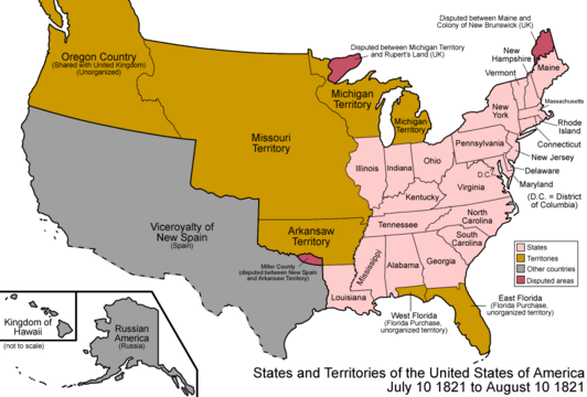
- Missouri Becomes a State (1821)
- On August 10, 1821, Missouri officially joined the Union. The remaining northwestern part of the Missouri Territory became "unorganized territory."
- The Treaty of Limits (1828-1832)
- This treaty between the U.S. and Mexico confirmed the border that had been set by the Adams–Onís Treaty.

- The U.S. Annexes Texas (1845)
- On December 29, 1845, Texas became a U.S. state. The U.S. took on Texas's land claims, which led to a dispute with Mexico.
- The U.S. Declares War on Mexico (1846)
- On May 13, 1846, the U.S. declared war on Mexico, starting the Mexican–American War.

- U.S. Army Seizes Santa Fe (1846)
- On August 15, 1846, the U.S. Army, led by General Stephen W. Kearny, captured Santa Fe. This was the capital of the Mexican province of Nuevo México.
- The Treaty of Guadalupe Hidalgo (1848)
- This treaty, signed on February 2, 1848, ended the Mexican–American War. Mexico gave a large amount of land to the U.S. This land became "unorganized territory" at first.

- The Provisional State of Deseret (1849)
- On March 10, 1849, Mormon settlers in the Great Salt Lake Valley formed their own temporary government called the State of Deseret. Brigham Young was their governor. This state claimed a huge area, including parts of what is now Colorado. However, the U.S. later created the Utah Territory in 1850.
- The Compromise of 1850
- On September 9, 1850, the U.S. approved several laws known as the Compromise of 1850. These laws created the New Mexico Territory and the Utah Territory. Parts of what is now Colorado were included in these new territories.

- The Kansas–Nebraska Act (1854)
- On May 30, 1854, President Franklin Pierce signed the Kansas–Nebraska Act. This law created the Kansas Territory and the Nebraska Territory. It allowed people in these territories to decide if they wanted slavery. This act led to more conflict and eventually the American Civil War.

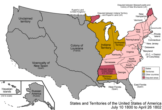
- The Provisional Territory of Jefferson (1859)
- On October 24, 1859, settlers in the Pike's Peak region formed their own temporary government. They called it the Jefferson Territory. This territory covered all of present-day Colorado and parts of other states. It acted as the government until the U.S. created the official Colorado Territory.
- Kansas Becomes a State (1861)
- On January 29, 1861, Kansas became a free state. The western part of the Kansas Territory that was left over became "unorganized territory." This area was added to the new Colorado Territory a month later.
.jpg)
_3.jpg)
- The Colorado Organic Act (1861)
- On February 28, 1861, President James Buchanan signed the Colorado Organic Act. This law created the Colorado Territory as a free territory. It replaced the Jefferson Territory and included parts of the Kansas, New Mexico, Utah, and Nebraska territories. The Colorado Territory existed until it became a state.
- The Colorado Enabling Act (1875)
- On March 3, 1875, President Ulysses S. Grant signed this act. It allowed the people of Colorado to create a constitution and become a state.
- Colorado Becomes a State (1876)
- On August 1, 1876, President Ulysses S. Grant officially announced that Colorado had met the requirements. Colorado joined the Union as a state.
Maps
-
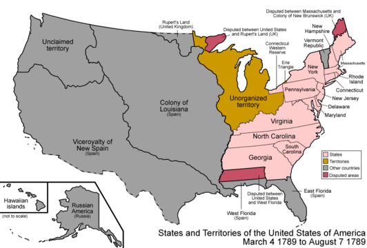
Map of the United States after the Constitution of the United States was approved on March 4, 1789.
-
Map of the United States after the secret Third Treaty of San Ildefonso transferred the Spanish colony of la Luisiana to France on October 1, 1800.
-
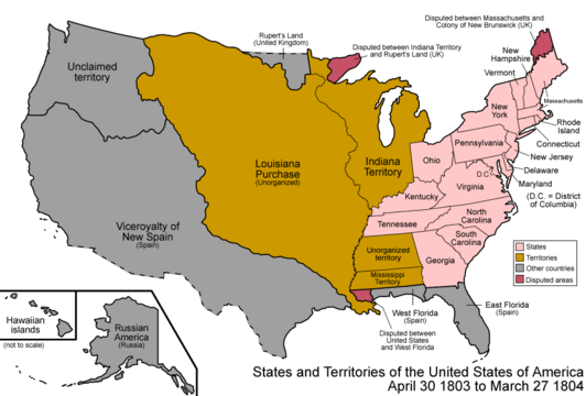
Map of the United States after the Louisiana Purchase took effect on December 20, 1803.
-
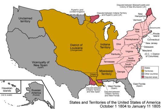
Map of the United States after the creation of the District of Louisiana on March 26, 1804.
-
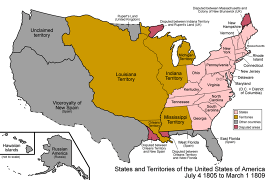
Map of the United States after the creation of the Louisiana Territory on March 3, 1805.
-
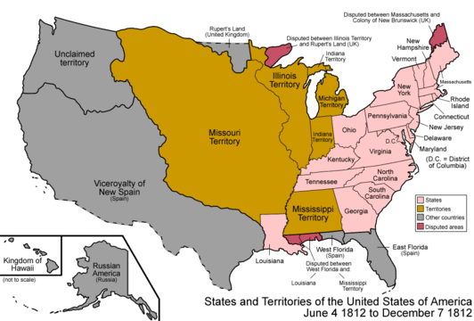
Map of the United States after the creation of the Missouri Territory on June 4, 1812.
-
Map of the United States after the Adams–Onís Treaty took effect on February 22, 1821.
-
Territorial claims of the Republic of Texas, May 2, 1836.
-
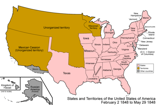
Map of the United States after the Treaty of Guadalupe Hidalgo was signed on February 2, 1848.
-
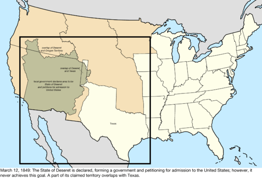
Map of the United States after the creation of the provisional State of Deseret on July 2, 1849.
-
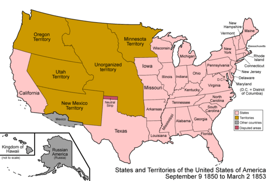
Map of the United States after the creation of the New Mexico Territory and the Utah Territory on September 9, 1850.
-
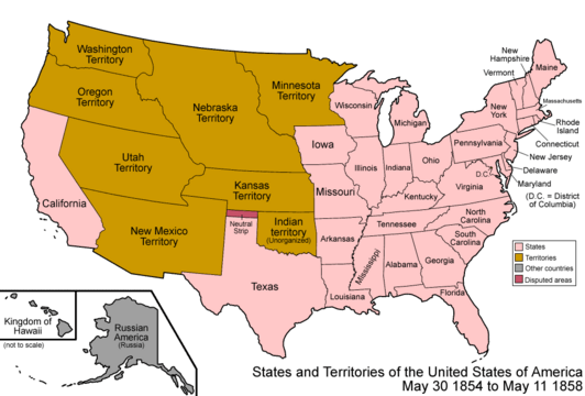
Map of the United States after the creation of the Kansas Territory and the Nebraska Territory on May 30, 1854.
-
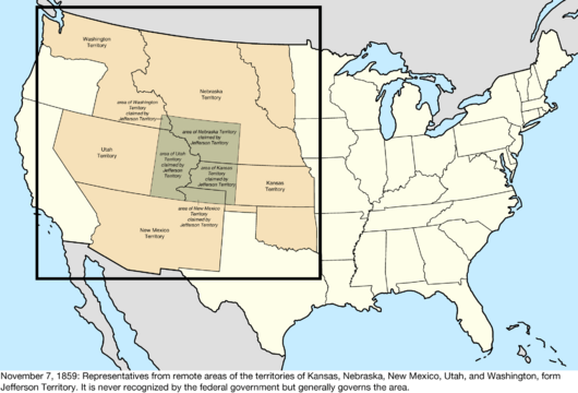
Map of the United States after the creation of the provisional Jefferson Territory on October 24, 1859.
-
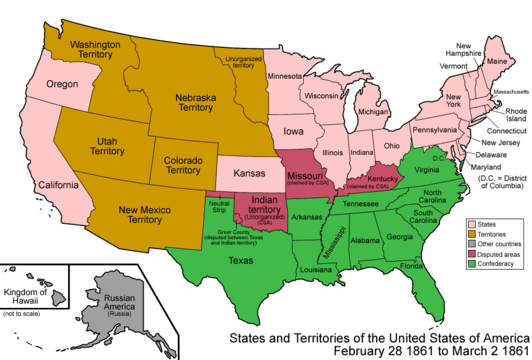
Map of the United States after the creation of the Colorado Territory on February 28, 1861.


