
Image: Volcanic Landscapes, Central Andes labelled
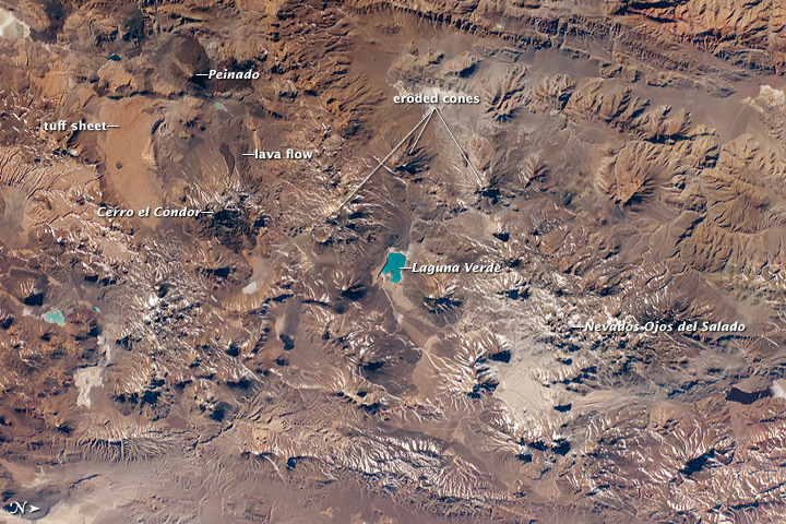
Description: The landscape in the central Andes Mountains, near the border between Chile and Argentina, is dominated by volcanoes and associated landforms. (The North arrow in the bottom left corner of this image is wrong. North is actually to the left in this image). Layers of older sedimentary rocks are visible to the upper middle, and many volcanic cones show grooves where water has eroded the rock to form gullies. Such erosion has occurred since the host volcano was built up, indicating that most volcanoes in this view have been inactive for centuries or millennia. A few volcanoes exhibit much less erosion, and even show tongues of dark, recent lava flows (upper left). Two of these volcanoes, Cerro el Cóndor and Peinado, have likely erupted within the past 12,000 years. Also visible is the world’s highest active volcano, Nevado Ojos del Salado, with a summit 6,887 meters (22,600 feet) above sea level. The most recent confirmed eruption has been dated to the year 700 (+/- 300 years), but minor eruptive activity may have occurred as recently as 1993. Stratovolcanoes such as Cerro el Cóndor, Peinado, and Nevado Ojos del Salado are formed partly by the buildup of lava flows and partly by the buildup of explosively vented material dropping back down onto the surface. One material associated with these eruptions is welded tuff, formed by molten and fragmented rock that accumulates on the ground and later solidifies. A large tuff sheet is visible at the top left. Formed very rapidly, these sheets have been termed “instant landscapes.” The Andean volcanic system has been so active that the origin of many tuffs cannot be pinpointed because the source vents have been overprinted by subsequent volcanic events. The landscape also shows that the erosive work of rivers and glaciers in the region is slower than the upward building processes of the volcanoes. The bright blue lake -- nearly 7 km (4.3 miles) long -- near the center of the image is Laguna Verde. This and other less obvious lakes indicate that water from snowmelt or direct precipitation is unable to reach the sea, being impounded in the depressions between the volcanic edifices.
Title: Volcanic Landscapes, Central Andes labelled
Credit: http://earthobservatory.nasa.gov/IOTD/view.php?id=45618
Author: Expedition 24 crew, ISS
Permission: Use of NASA logos, insignia and emblems is restricted per U.S. law 14 CFR 1221. The NASA website hosts a large number of images from the Soviet/Russian space agency, and other non-American space agencies. These are not necessarily in the public domain. Materials based on Hubble Space Telescope data may be copyrighted if they are not explicitly produced by the STScI.[1] See also Template:PD-Hubble and Template:Cc-Hubble. The SOHO (ESA & NASA) joint project implies that all materials created by its probe are copyrighted and require permission for commercial non-educational use. [2] Images featured on the Astronomy Picture of the Day (APOD) web site may be copyrighted. [3] The National Space Science Data Center (NSSDC) site has been known to host copyrighted content. Its photo gallery FAQ states that all of the images in the photo gallery are in the public domain "Unless otherwise noted."
Usage Terms: Public domain
License: Public domain
Attribution Required?: No
Image usage
The following page links to this image:
