
Image: WOA05 GLODAP pd pH AYool

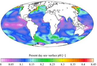
Description: Estimated annual mean sea surface pH for the present day (1990s). Calculated from fields of dissolved inorganic carbon and alkalinity from the Global Ocean Data Analysis Project climatology and temperature and salinity from the World Ocean Atlas (2005) climatology using Richard Zeebe's csys package. It is plotted here using a Mollweide projection (using MATLAB and the M_Map package). Note that the GLODAP climatology is missing data in certain oceanic provinces including the Arctic Ocean, the Caribbean Sea, the Mediterranean Sea and the Malay Archipelago.
Title: WOA05 GLODAP pd pH AYool
Credit: Own work
Author: Plumbago
Usage Terms: Creative Commons Attribution-Share Alike 3.0
License: CC BY-SA 3.0
License Link: http://creativecommons.org/licenses/by-sa/3.0
Attribution Required?: Yes
Image usage
The following page links to this image:
