
Image: Ward Hunt Island, Geomorphology, Map2, Ellesmere Island, Nunavut, Canada

Size of this preview: 800 × 562 pixels. Other resolutions: 320 × 225 pixels | 10,892 × 7,657 pixels.
Original image (10,892 × 7,657 pixels, file size: 16 MB, MIME type: image/jpeg)
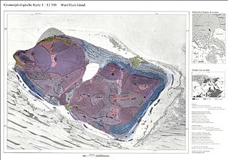
Description: The geomorphological map is based on the Topographical Map Ward Hunt Island, scale 1:25,000 (“Bachmann Map”), produced by Günter Hell and his team. Field work on Ward Hunt Island for these maps was done in summer 1988 by Günter Hell (University of Applied Science Karlsruhe) and Wolfgang Zick, Karlsruhe University (KIT), section geodesy, Additional observations in April 1990 by Lorenz King, expedition leader.
Title: Ward Hunt Island, Geomorphology, Map2, Ellesmere Island, Nunavut, Canada
Credit: Own work
Author: Matti&Keti
Usage Terms: Creative Commons Attribution-Share Alike 4.0
License: CC BY-SA 4.0
License Link: https://creativecommons.org/licenses/by-sa/4.0
Attribution Required?: Yes
Image usage
The following page links to this image:

All content from Kiddle encyclopedia articles (including the article images and facts) can be freely used under Attribution-ShareAlike license, unless stated otherwise.