
Ward Hunt Island facts for kids
 |
|
 |
|

Ward Hunt Island
Location in Nunavut

Ward Hunt Island
Location in Canada
|
|
| Geography | |
|---|---|
| Location | Northern Canada |
| Coordinates | 83°06′N 074°10′W / 83.100°N 74.167°W |
| Archipelago | Queen Elizabeth Islands |
| Area | 13.9 km2 (5.4 sq mi) |
| Highest elevation | 415 m (1,362 ft) |
| Highest point | Walker Hill |
| Administration | |
|
Canada
|
|
| Territory | Nunavut |
| Region | Qikiqtaaluk |
| Demographics | |
| Population | Uninhabited |
Ward Hunt Island is a small, empty island in the far north of Canada. It is located in the Arctic Ocean, just off the north coast of Ellesmere Island. The northern tip of Ward Hunt Island is one of the most northern land spots in Canada. Only a small stretch of Ellesmere Island, near Cape Columbia, is even further north. The island is about 6.5 kilometers (4 miles) long from east to west. It is also about 3.3 kilometers (2 miles) wide.
The first time this island was seen by explorers was in 1876. It was spotted by Pelham Aldrich, who was a lieutenant with the George Nares expedition. The island was named after George Ward Hunt. He was in charge of the British Navy at that time.
Contents
Island History and Exploration
Ward Hunt Island has played a small but important role in Arctic exploration. It has been a starting point for many journeys.
Early Uses of the Island
For a short time, Ward Hunt Island was used as a weather station. This happened during the International Geophysical Year in 1957-58. After that, it became a popular place for people trying to reach the North Pole. The first famous attempt from here was by Ralph Plaisted in 1968. Today, there is still a small airstrip on the island. There is also a building on the north shore.
Mapping the Arctic Land
In July 1988, a group of scientists visited the island. They were from universities in Germany. This team carefully measured and mapped the island. They also mapped the ice shelf next to it. Their work helped create the first detailed maps of Ward Hunt Island. These maps showed the land and how it was formed.
Changes in the Ice Shelf
The ice around Ward Hunt Island is part of a large ice shelf. These ice shelves are huge sheets of ice that float on the ocean. On July 29, 2008, a very large piece of ice broke off from the Ward Hunt Island ice shelf. This new ice island was about 35.9 square kilometers (13.9 square miles) in size. It was the biggest piece to break off since 2005. That year, the nearby Ayles Ice Shelf also broke apart.
Messages from the Past
In 1959, an American geologist named Paul T. Walker left a special message. He put a note in a bottle and built a pile of rocks, called a cairn, over it. This was near a glacier about 800 kilometers (500 miles) north of Grise Fiord, Nunavut. His note said the cairn was 1.2 meters (4 feet) in front of the glacier. He asked whoever found it to measure the distance again. At that time, most scientists did not expect glaciers to shrink.
Researchers from Laval University found the bottle in 2013. By then, the distance from the cairn to the glacier was 101.5 meters (333 feet). This showed how much the glacier had melted and moved back.
A Prime Minister's Visit
In July 2016, a team of Canadian scientists visited Ward Hunt Island. They were part of the Canadian Armed Forces. While there, they found another cairn. This one was built in 1975 by the Prime Minister of Canada at the time, Pierre Trudeau. He had visited the island with his two sons, Justin Trudeau and Alexandre Trudeau. A picture of the plaque on the cairn was later given to the current Prime Minister, Justin Trudeau. He is one of Pierre Trudeau's sons.
Images for kids
-
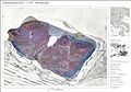
This map shows the land features of Ward Hunt Island.
-
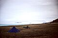
A view of the field camp and airstrip on Ward Hunt Island.


