Ayles Ice Shelf facts for kids

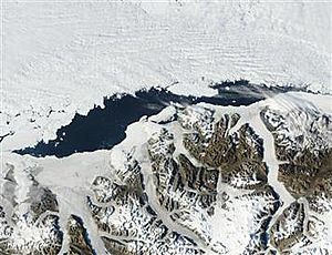
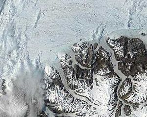
The Ayles Ice Shelf was a huge sheet of ice located on the north coast of Ellesmere Island in Nunavut, Canada. It was one of Canada's six main ice shelves. This massive ice shelf broke away from the coast on August 13, 2005. When it broke off, it formed a giant ice island.
This new ice island was about 37 m (121 ft) thick. It measured around 14 by 5 km (8.7 by 3.1 mi), which is about 55 km2 (21 sq mi) in total area. The amount of ice that broke off was roughly 2.6 km3 (0.62 cu mi) in volume. Scientists believe that some of the ice in the shelf was over 3,000 years old. The Ayles Ice Shelf was located at (82°52′N 80°30′W / 82.867°N 80.500°W), which is about 800 km (500 mi) south of the North Pole.
Like the nearby Mount Ayles, the Ayles Ice Shelf was named after Adam Ayles. He was an Arctic explorer who served on the ship HMS Alert during the British Arctic Expedition. A study in 1986 showed that 48 km2 (19 sq mi) of ice, or 3.3 km3 (0.79 cu mi) in volume, broke off from the Milne and Ayles ice shelves between 1959 and 1974. Overall, Canada lost 94% of its ice shelf area between 1906 and 2015.
The Ayles Ice Island
On August 13, 2005, the entire Ayles Ice Shelf completely broke away from the coast of Ellesmere Island. This created a brand new ice island. It is thought to be the biggest ice shelf breakup of its kind in Canada in over 30 years. The event was so large that seismometers in northern Canada recorded it. Satellite images also confirmed the breakup.
The breakup happened very quickly, in less than an hour. The Canadian Ice Service noticed the event when it occurred. However, it took another 16 months to fully understand what happened. Scientists used old satellite images from the Moderate Resolution Imaging Spectroradiometer (MODIS) to piece together the breakup. They also studied the weather conditions at the time. This event, which has been connected to global warming, is similar to the breakup of the Larsen B Ice Shelf in Antarctica in 2002.
Within days of breaking off, the former ice shelf drifted over 50 km (31 mi) away from Ellesmere Island. It then froze into the surrounding sea ice for the winter. In May 2007, scientists estimated the Ayles Ice Island was between 42 and 45 m (138 and 148 ft) thick on average.
The part of the ice shelf that broke free is known as the Ayles Ice Island. It drifted southwest for two years. In January 2007, it moved into the open Arctic Ocean. This caused worry for oil rig operators in the Beaufort Sea, north of Prudhoe Bay, Alaska. However, in August 2007, the island became stuck in the Sverdrup Inlet of the Queen Elizabeth Islands. Scientists first thought it might stay there for a long time, maybe even forever. But soon after, it broke into two pieces and started moving again.
There is concern that these large ice islands could be dangerous for ships and oil platforms.
Other Giant Ice Islands
The formation of the Ayles Ice Island got a lot of attention. This was partly because satellite images were available, and scientists and news reporters could visit the island. However, it was not the first time such a large ice island had formed.
On August 14, 1946, a U.S. Air Force plane flying 480 km (300 mi) north of Point Barrow spotted an ice island called T-1. It was huge, measuring 24 by 29 km (15 by 18 mi). It was estimated to be from 62 to 488 m (204 to 1,600 ft) thick, with sides rising 9.1 to 61.0 m (30 to 200 ft) above the sea. This was much larger than the Ayles Ice Island. Over the next three years, T-1 traveled about 2,400 km (1,500 mi). It followed the Beaufort Eddy, a slow ocean current that moves east across the North Pole and then west along the coast.
In 1950, the U.S. Air Force was ordered to find T-1 and any other ice islands in the Arctic. In July 1950, they found T-2, a roughly rectangular ice island about 32 by 32 km (20 by 20 mi). A joint U.S.-Canadian trip in 1947 had already seen and photographed a large ice formation off Ellesmere Island. By looking at photos of its ridges, scientists realized T-2 was the same ice island seen in 1947. Later in July 1950, the U.S. Air Force found Fletcher's Ice Island, also known as T-3. This was a kidney-shaped island, 14.5 by 7.2 km (9 by 4.5 mi). People even lived on T-3 for short periods in the early and mid-1950s. In August 1951, T-1 was found again, resting along the coast of Ellesmere Island.
It's not known exactly when T-1, T-2, and T-3 first formed. However, it is believed they broke off from ice shelves on northern Ellesmere Island. Today, there are an estimated 80 ice islands in Canada's High Arctic. Most of them are part of the pack ice that covers the region.
Between August 1961 and April 1962, nearly 600 km2 (230 sq mi) of ice broke away from the Ward Hunt Ice Shelf. This event was thought to be caused by tides and earthquakes.
 | James Van Der Zee |
 | Alma Thomas |
 | Ellis Wilson |
 | Margaret Taylor-Burroughs |


