
Image: West ukraine

Size of this preview: 564 × 599 pixels. Other resolutions: 226 × 240 pixels | 874 × 929 pixels.
Original image (874 × 929 pixels, file size: 62 KB, MIME type: image/png)
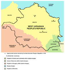
Description: Map of the areas claimed by the West Ukrainian People's Republic in 1918.
Title: West ukraine
Credit: Own work
Author: PANONIAN
Permission: This map has been uploaded by Electionworld from en.wikipedia.org to enable the Wikimedia Atlas of the World . Original uploader to en.wikipedia.org was PANONIAN, known as PANONIAN at en.wikipedia.org. Electionworld is not the creator of this map. Licensing information is below.
Usage Terms: Public domain
License: Public domain
Attribution Required?: No
Image usage
The following page links to this image:

All content from Kiddle encyclopedia articles (including the article images and facts) can be freely used under Attribution-ShareAlike license, unless stated otherwise.