
Image: Xangsane TRMM total rainfall
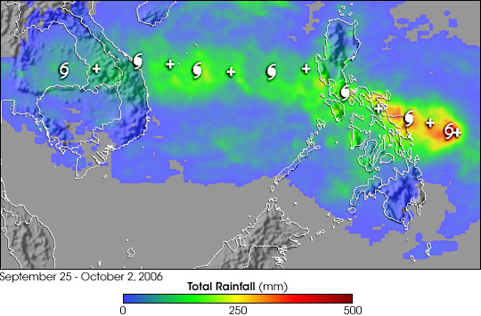
Description: After forming just east of the central Philippines, Tropical Storm Xangsane (“elephant” in Lao) intensified into a typhoon and battered the central Philippines with high winds and heavy rains on September 27 and 28, 2006. At least 110 people were reported killed, with many still missing as a result of flooding and mudslides brought on by the storm as of early October. After passing through the Philippines and out into the South China Sea, Xangsane headed for the central coast of Vietnam, where it made landfall on October 1. The storm caused widespread damage and flooding in Vietnam, and at least 59 people were reported to have died there as a result. This image shows rainfall totals estimated in part from data collected by the Tropical Rainfall Measuring Mission satellite (TRMM). TRMM data are part of the near-real-time Multi-satellite Precipitation Analysis (MPA) at NASA Goddard Space Flight Center, which monitors rainfall over the global Tropics. MPA rainfall totals for Southeast Asia for September 25-October 2, 2006, are shown in the image. Storm symbols mark Xangsane’s path. Rainfall totals of over a foot are shown over Samar in the east-central Philippines (red areas). A broad area of 4- to 8-inch totals (green) stretches from the central Philippines to the coast of Vietnam. TRMM was placed into service in November of 1997. From its low-earth orbit, TRMM has been measuring rainfall over the global Tropics using a combination of passive microwave and active radar sensors. TRMM is a joint mission between NASA and the Japanese space agency, JAXA.
Title: Xangsane TRMM total rainfall
Credit: http://earthobservatory.nasa.gov/NaturalHazards/natural_hazards_v2.php3?img_id=13917
Author: Image produced by Hal Pierce (SSAI/NASA GSFC) and caption by Steve Lang (SSAI/NASA GSFC).
Permission: This file is in the public domain in the United States because it was solely created by NASA. NASA copyright policy states that "NASA material is not protected by copyright unless noted". (See Template:PD-USGov, NASA copyright policy page or JPL Image Use Policy.) Warnings: Use of NASA logos, insignia and emblems is restricted per U.S. law 14 CFR 1221. The NASA website hosts a large number of images from the Soviet/Russian space agency, and other non-American space agencies. These are not necessarily in the public domain. Materials based on Hubble Space Telescope data may be copyrighted if they are not explicitly produced by the STScI.[1] See also Template:PD-Hubble and Template:Cc-Hubble. The SOHO (ESA & NASA) joint project implies that all materials created by its probe are copyrighted and require permission for commercial non-educational use. [2] Images featured on the Astronomy Picture of the Day (APOD) web site may be copyrighted. [3] The National Space Science Data Center (NSSDC) site has been known to host copyrighted content even though its photo gallery FAQ states that all of the images in the photo gallery are in the public domain.
Usage Terms: Public domain
License: Public domain
Attribution Required?: No
Image usage
The following page links to this image:
