
Typhoon Xangsane facts for kids
| Typhoon (JMA scale) | |
|---|---|
| Category 4 typhoon (SSHWS) | |

Xangsane east of the Philippines on September 27
|
|
| Formed | September 25, 2006 |
| Dissipated | October 1, 2006 |
| Highest winds | 10-minute sustained: 175 km/h (110 mph) 1-minute sustained: 230 km/h (145 mph) |
| Lowest pressure | 935 hPa (mbar); 27.61 inHg |
| Fatalities | At least 312 total |
| Damage | $750 million (2006 USD) |
| Areas affected | Philippines, Hainan, Vietnam, Cambodia, Thailand |
| Part of the 2006 Pacific typhoon season | |
Typhoon Xangsane, also known as Typhoon Milenyo in the Philippines, was a very strong and dangerous storm in 2006. It hit countries like the Philippines, Vietnam, and Thailand. The name Xangsane means 'elephant' in Laos. This typhoon was so powerful that experts called it a Category 4 typhoon, based on its wind speeds.
When Xangsane hit the Philippines, it brought huge amounts of rain and very strong winds. This caused a lot of flooding and landslides, especially in the northern islands. After crossing the Philippines, the typhoon moved over the South China Sea. It then hit Vietnam and caused more flooding and landslides there, and also in Thailand. Sadly, this typhoon led to at least 312 deaths. It also caused about $750 million in damage, which is a lot of money!
How Typhoon Xangsane Formed and Grew

Typhoon Xangsane started as a small area of stormy weather on September 24, 2006. It was located southeast of Manila, in the Philippines. Weather experts began watching it closely.
On September 25, this stormy area became a tropical depression. This is the first stage of a typhoon. It was given the local name Milenyo by the Philippines. As it moved west, it quickly grew stronger.
By September 26, the storm was officially named Xangsane. It continued to gain power rapidly. Just a day later, Xangsane became a full typhoon. Its winds were incredibly strong, reaching speeds of up to 230 kilometers per hour (145 miles per hour).
Xangsane then moved across the Philippine islands. It caused a lot of damage, especially in Metro Manila. This was the strongest typhoon to directly hit Manila in eleven years. After leaving the Philippines, it went over the South China Sea.
Even though it weakened a bit, Xangsane soon got stronger again. It made a second landfall in Da Nang, Vietnam, on October 1. After hitting Vietnam, the storm slowly lost its power. It moved inland over Thailand before finally fading away.
Getting Ready for the Storm in the Philippines

On September 27, 2006, the Philippine weather agency, PAGASA, issued serious warnings. They raised Storm Signal Number 3 for parts of southern Luzon. This meant winds of 100–185 kilometers per hour (62–115 miles per hour) were expected.
Storm Signal Number 2 was issued for northern Samar Island and central Luzon. This warned of winds between 60–100 kilometers per hour (37–62 miles per hour). Even Metro Manila was under Storm Signal Number 1, expecting winds of 30–60 kilometers per hour (20–37 miles per hour).
Because of these warnings, schools in the affected areas were closed. Airports and seaports also stopped operations to keep people safe. Many flights were cancelled, and public transportation was suspended. People in Metro Manila and nearby areas were told to prepare for heavy flooding and strong winds.
As Xangsane got closer to the capital city, PAGASA upgraded the warning for Manila. On September 28, Manila and central Luzon were placed under Storm Signal Number 3. This showed how dangerous the typhoon was expected to be. All warnings were removed later that day after the typhoon passed.
Images for kids
-
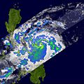
This image shows Xangsane's clear eye before it first hit land.
-
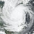
Xangsane over eastern Indochina after hitting land.
-
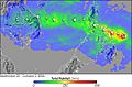
This image shows how much rain fell in Southeast Asia from September 25 to October 2, 2006. The red areas over Samar in the Philippines show over a foot of rain. Green areas show 4 to 8 inches of rain from the Philippines to Vietnam.
-
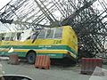
A passenger bus was crushed by a billboard along EDSA in Makati City.


