Samar facts for kids

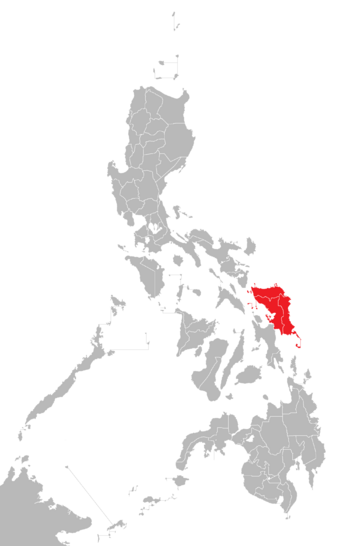
Location within the Philippines
|
|
| Geography | |
|---|---|
| Coordinates | 12°00′N 125°00′E / 12.000°N 125.000°E |
| Archipelago | Visayas |
| Adjacent bodies of water |
|
| Area | 13,428.8 km2 (5,184.9 sq mi) |
| Area rank | 63rd |
| Coastline | 800.6 km (497.47 mi) |
| Highest elevation | 890 m (2,920 ft) |
| Highest point | Mount Huraw |
| Administration | |
| Region | Eastern Visayas |
| Provinces |
|
| Largest settlement | Calbayog (pop. 186,960) |
| Demographics | |
| Population | 1,909,537 (2020) |
| Pop. density | 140 /km2 (360 /sq mi) |
| Ethnic groups | Visayans (Waray-Waray) |
Samar is a large island in the Philippines. It is the third-largest island in the country. About 1.9 million people live there, based on the 2020 census. Samar is found in the eastern part of the Visayas region, which is in the central Philippines.
The island is divided into three provinces: Samar (also known as Western Samar), Northern Samar, and Eastern Samar. These provinces, along with others on nearby islands like Leyte and Biliran, form the Eastern Visayas region. A big part of Samar, about one-third, is a protected area called the Samar Island Natural Park. This park helps protect the island's natural beauty and wildlife.
On June 19, 1965, Samar was officially divided into its three current provinces. This day is now a special holiday in the region. Many people get the day off from work to celebrate this important event. The capital cities for these provinces are Catarman for Northern Samar, Catbalogan for Samar province, and Borongan for Eastern Samar.
Contents
Exploring Samar's Geography
Samar is a very large island. It is the third biggest in the Philippines, only smaller than Luzon and Mindanao. The highest point on Samar is Mount Huraw, which stands about 890 meters (2,920 feet) tall.
Samar is the easternmost island in the Visayas. It is located northeast of Leyte island. A narrow waterway called the San Juanico Strait separates them. At its narrowest, this strait is only about 2 kilometers wide. The San Juanico Bridge connects Samar and Leyte across this strait.
To the southeast of Luzon's Bicol Peninsula, Samar is separated by the San Bernardino Strait. To the south of Samar is Leyte Gulf. This gulf was the site of a very important naval battle during World War II in October 1944. To the north and east of Samar lies the Philippine Sea, which is part of the huge Pacific Ocean.
Samar's Rich History
Samar has a long and interesting history. It was the first island in the Philippines that European explorers saw.
Early Discoveries and Names
In 1521, the Spanish expedition led by Ferdinand Magellan sighted Samar. Magellan's diary, written by Antonio Pigafetta, called the island "Zamal." This happened on March 16, 1521, after they sailed from the Mariana Islands. Magellan named the islands he saw "San Lazaro" because it was a special day for Saint Lazarus.
Even though Samar was the first island Magellan saw, he did not land there. He continued sailing south. He stopped at Suluan Island and then landed on Homonhon Island on March 17, 1521. Later, in the 1700s, records show that Samar had many local families and some Spanish families living there.
Other Spanish explorers arrived years later. Historians have written about early leaders on Samar. For example, a local leader named Iberein was said to have visited a Spanish ship in 1543. He wore gold earrings and chains, showing the wealth of the area. There are also old stories, called siday, about a powerful leader named Bingi from a prosperous area in Samar called Lawan.
Samar was also known by other names in early Spanish writings. These included Ibabao (or Cibabao), Achan, Camlaya, and Taridola. Sometimes, Spanish captains mistakenly called the island "Tandaya" after a local lord.
The Philippine-American War
Samar played a big role in the final part of the Philippine–American War (1899-1902). This period was known for some very tough battles.
One famous event happened on September 28, 1901, in Balangiga. Filipino forces, led by Eugenio Daza and Valeriano Abanador, attacked a U.S. Army company. This attack was one of the few Filipino victories in the war. It was also a big defeat for the American forces at the time.
To remember this important victory, "Balangiga Encounter Day" is now a provincial holiday in Eastern Samar. The events in Balangiga led to a difficult period for the people of Samar. The American forces responded with harsh actions, which caused much suffering on the island.
Samar in World War II
During World War II, the waters near Samar were the site of a major naval battle. This was the Battle off Samar on October 25, 1944. In this battle, a smaller American naval force fought against a much larger Japanese fleet. The Japanese fleet included the huge battleship Yamato. This battle was a very important moment in the war. Samar island was also part of a large U.S. Navy base during World War II.
Samar's Population
Samar is home to many people. The population has grown steadily over the years.
| Population of Samar | ||||||||||||||||||||||||||||||||||||||||||||||||||||
|---|---|---|---|---|---|---|---|---|---|---|---|---|---|---|---|---|---|---|---|---|---|---|---|---|---|---|---|---|---|---|---|---|---|---|---|---|---|---|---|---|---|---|---|---|---|---|---|---|---|---|---|---|
|
|
|||||||||||||||||||||||||||||||||||||||||||||||||||
| Source: Philippine Statistics Authority | ||||||||||||||||||||||||||||||||||||||||||||||||||||
 | George Robert Carruthers |
 | Patricia Bath |
 | Jan Ernst Matzeliger |
 | Alexander Miles |

