Leyte facts for kids

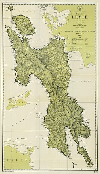
1933 map of Leyte
|
|

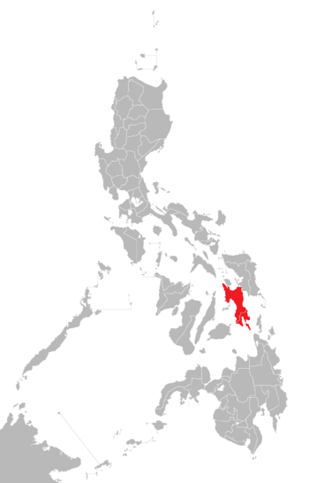
Location within the Philippines
|
|
| Geography | |
|---|---|
| Location | Southeast Asia |
| Coordinates | 10°50′N 124°50′E / 10.833°N 124.833°E |
| Archipelago | Visayas |
| Adjacent bodies of water |
|
| Area | 7,367.6 km2 (2,844.6 sq mi) |
| Highest elevation | 1,332 m (4,370 ft) |
| Highest point | Alto Peak |
| Administration | |
| Region | Eastern Visayas |
| Provinces |
|
| Largest settlement | Tacloban City (pop. 251,881) |
| Demographics | |
| Population | 2,626,970 (2020) |
| Pop. density | 324.2 /km2 (839.7 /sq mi) |
| Ethnic groups |
|
Leyte is a large island in the Visayas group of islands in the Philippines. It is the eighth-largest island in the Philippines and the sixth most populated. As of 2020, about 2.6 million people live there.
Most people on Leyte are farmers, growing crops like rice, corn, coconuts, and bananas. Fishing is also an important activity. The island has some valuable minerals like manganese, and people also quarry sandstone and limestone. Many people from Leyte have moved to Mindanao over the years.
Leyte is divided into two provinces: Northern Leyte and Southern Leyte. The island of Panaon is part of Southern Leyte. To the north of Leyte is Biliran, which used to be a part of Leyte.
The two biggest cities on Leyte are Tacloban, located on the eastern coast, and Ormoc, on the west coast. Today, Leyte is also known for its geothermal power plants near Ormoc, which use heat from the Earth to make electricity.
Contents
Leyte's Past: A Look at History
Leyte has a rich history, from ancient times to important events in modern history.
Early History of Leyte
In the 1500s, Spanish explorers called the island Tandaya. Its population grew a lot after 1900. Long ago, a community called Mairete existed here, ruled by a leader named Datu Ete. Before the Spanish arrived, the island was home to native Warays in the east and other native Visayan groups in the west. These groups had their own beliefs and traditions.
In the early 1600s, a priest named Father Ignacio Alcina wrote about a local epic story. It told of Datung Sumanga from Leyte who won the hand of Princess Bugbung Humasanum of Bohol by raiding Imperial China. Their marriage was said to have started a kingdom there.
Leyte During Colonial Times
On some early Spanish maps of the Philippines, Leyte was called Ceylon. In the 1700s, about 38 Spanish-Filipino families and 7,678 native families lived on the island.
Leyte in World War II
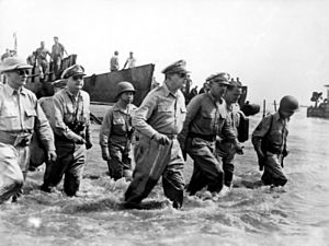
Leyte is very famous for its role in World War II. It was a key place in the reconquest of the Philippines. On October 20, 1944, General Douglas MacArthur famously landed on Leyte, declaring, "I have returned."

The Japanese fought back strongly in the Battle of Leyte. This led to the four-day Battle of Leyte Gulf, which was the largest naval battle in history. During World War II, Leyte was also a large US Navy base.
Exploring Leyte's Geography
Leyte is a long island, stretching about 180 kilometers (112 miles) from north to south. At its widest point, it is about 65 kilometers (40 miles) across.
To the north, Leyte is very close to the island of Samar. They are separated by the San Juanico Strait, which is only about 2 kilometers (1.2 miles) wide in some places. The island province of Biliran is also north of Leyte and is connected to it by a bridge.
To the south, Leyte is separated from Mindanao by the Surigao Strait. To the east, Leyte is set back from the Philippine Sea of the Pacific Ocean. Samar to the northeast and the Dinagat Islands to the southeast form the Leyte Gulf. To the west of Leyte is the Camotes Sea.
Most of Leyte is covered in thick forests and mountains. However, the Leyte Valley in the northeast is a major farming area.
Leyte's Population Growth
The number of people living on Leyte Island has grown steadily over the years.
Famous Places and Natural Wonders
Leyte is home to many interesting historical sites and beautiful natural attractions.
- Leyte Provincial Capitol: This building is where the provincial government works. Inside, you can see a large painting showing the First Mass in the Philippines, which is believed to have happened in Limasawa. There is also a mural depicting General Douglas MacArthur's landing.
- MacArthur Landing Memorial National Park: Located in Red Beach, Palo, this park marks the spot where American forces landed in 1944 to liberate the Philippines. It has a lagoon with a life-sized statue of General MacArthur.
- Mahagnao Volcano Natural Park: Found in Burauen, about 66 kilometers (41 miles) from Tacloban City, this park is a great place for visitors. It features lakes, volcanic craters, hot springs, colorful mud, and untouched forests. It became a national park in 1937. The park is 1,200 meters (3,937 feet) above sea level and covers 635 hectares (1,570 acres).
- Lake Danao: This unique lake is shaped like a guitar and is surrounded by the cloud-covered Anonang-Lobi mountains.
- Kalanggaman Island: Located in Palompon, Leyte, this island is known for its pure white sand and untouched natural beauty. The local government has worked hard to protect its environment.
- Sto. Nino Shrine and Heritage Museum: This museum has paintings of the fourteen stations of the cross by Filipino artists. It also features a bas-relief (a type of sculpture) showing the legend of the first Filipino man and woman, Malakas and Maganda.
- San Juanico Bridge: This impressive bridge is the longest in the Philippines, connecting Leyte to Samar.
Leyte Island is also the birthplace of the Tinikling dance, a popular traditional dance throughout the Philippines.
Recent Events and Infrastructure
Leyte has faced natural challenges and built projects to protect its communities.
On November 8, 2013, Super Typhoon Yolanda (Haiyan) caused massive destruction, damaging 70-80% of buildings in Leyte province. An estimated 10,000 people died, and up to 620,000 people were forced to leave their homes. Leyte was also affected by Tropical Storm Megi (2022).
Protecting Leyte from Floods
The Leyte Tide Embankment Project was created after Typhoon Haiyan. This project aims to build safer cities and communities by creating a flood control system. It will stretch for about 27.3 kilometers (17 miles) along the coast, from Barangay Diit in Tacloban City, through the shoreline of Palo, Leyte, and ending in Barangay Ambao of Tanauan, Leyte.
 | Lonnie Johnson |
 | Granville Woods |
 | Lewis Howard Latimer |
 | James West |


