
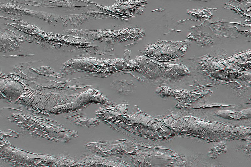
Image: Zagros Mountains, Iran, SRTM Shaded Relief Anaglyph
Description: The Zagros Mountains in Iran offer a visually stunning topographic display of geologic structure in layered sedimentary rocks. This scene is nearly 100 kilometers (62 miles) wide but is only a small part of similar terrain that covers much of southern Iran. This area is actively undergoing crustal shortening, as global tectonics moves Arabia toward Asia. Consequently, layers of sedimentary rock are folding much like a carpet will fold if pushed. The convex upward folds create structures called anticlines, which are prominently seen here. The convex downward folds (between the anticlines) create structures called synclines, which are mostly buried and hidden by sediments eroding off the anticlines. Layers having differing erosional resistance create distinctive patterns, often sawtooth triangular facets, that encircle the anticlines. Local relief between the higher mountain ridges and their intervening valleys is about 1,200 meters (about 4,000 feet).
Title: Zagros Mountains, Iran, SRTM Shaded Relief Anaglyph
Credit: http://www.jpl.nasa.gov/spaceimages/details.php?id=PIA04955
Author: NASA
Usage Terms: Public domain
License: Public domain
Attribution Required?: No
Image usage
The following page links to this image:
