
Image: Zirid control circa 980 (version 2)
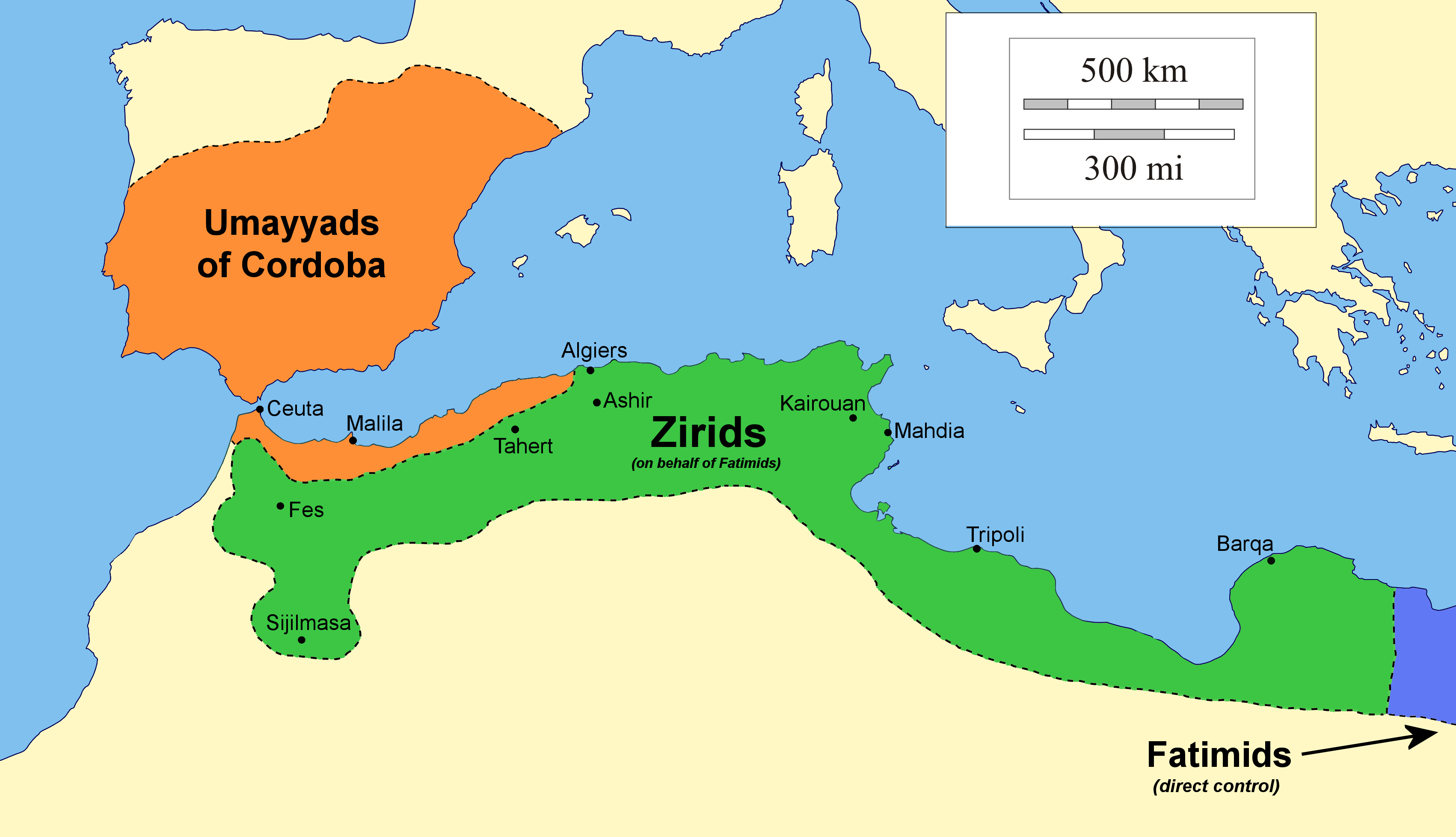
Description: Extent of Zirid authority circa 980, after the largest gains made by Buluggin ibn Ziri. Note that many of the Zirid and Umayyad territories shown here were only held temporarily, as the political situation in the western Maghreb constantly changed during the 10th century, Source: Sluglett, Peter & Currie, Andrew (2014). "Atlas of Islamic History" pp. 26, 28 (Maps 10 & 11)[1] Notes: 1) Combination of two maps in the source to determine eastern border: This map combines the Zirid territories shown in both maps 10 and 11 of the source above. Map 11 shows Zirid territory extending up to Cyrenaica, whereas map 10 doesn't. The authors do not explain this difference explicitly. However, other text sources indicate that Buluggin ibn Ziri was given control of Tripolitania in 978 (see, among others, Abun-Nasr, Jamil (1987). "A history of the Maghrib in the Islamic period", p. 67) and some sources indicate that he also would have controlled cities as far as Ajdabiya: Fehérvári, Géza (2002). "Excavations at Surt (Medinat Al-Sultan) Between 1977 and 1981", p. 17 [2] Idris, Hady R. and Halm, Heinz (2011), "Buluggīn b. Zīrī", in Fleet, Kate; Krämer, Gudrun; Matringe, Denis; Nawas, John; Rowson, Everett (eds.). "Encyclopaedia of Islam, Three", ISBN 9789004161658. Bramoullé, David (2019), "Les Fatimides et la mer (909-1171)", p.239 [3] To note a counterpoint, however, this source also states that the Fatimid caliph retained direct control of Barqa, also in Cyrenaica. But also, another source indicates that Barqa was at least given to the Zirids in 1012, see: Brett, Michael (2015), "The diplomacy of empire: Fatimids and Zirids, 990—1062" in Bulletin of the School of Oriental and African Studies, vol 78, no. 1, pp. 149-159 (see p.157 specifically [4]). In short, the status of Barqa is the most questionable detail here. Additionally, another published map appears to show indirect Fatimid authority circa 1000 as applying to the exact same areas of Cyrenaica (and therefore presumably under Zirid control, given the context), see: Bramoullé, David (2018), "Itinerant Objects in the Fatimid World: From Cairo to al-Andalus to Sicily and Back" Melikian-Chirvani, Assadullah Souren, (ed.), "The World of the Fatimids", p. 247 For these reasons, the slight lack of clarity notwithstanding, it seemed reasonable to combine the two relevant maps of the Sluglett and Currie atlas, seeing as they fit with what sources say about the gains made during Buluggin's reign. Note that if for some reason the representation/combination of content from both maps of the Sluglett and Currie atlas is not desirable, another version of this map (version 3) has been uploaded showing only the territories illustrated in Map 10 (p.26). 2) Other reliable sources used to determine details of western border: A bulge north of Fez and the Midrarid territory south of Fez have been included in Zirid territory, as at least two reliable sources state that Buluggin's 980 campaign captured Sijilmasa, Fez, and Basra (al-Hamra), the latter being a northern town (south of present-day Ksar el-Kebir): Idris, Hady R. and Halm, Heinz (2011), "Buluggīn b. Zīrī", in Fleet, Kate; Krämer, Gudrun; Matringe, Denis; Nawas, John; Rowson, Everett (eds.). "Encyclopaedia of Islam, Three", ISBN 9789004161658. Bennison, Amira K. (2012), in Akyeampong, Emmanuel Kwaku and Gates, Henry Louis (eds.), "Dictionary of African Biography", p. 9 [5] The location of Basra here is approximate, and the Sluglett and Currie maps do not show this northern bulge. If this representation is undesirable, there is again another version (version 1) of this map which sticks strictly to the borders shown by Maps 10 and 11 of the Sluglett and Currie atlas and therefore does not take into account a Zirid capture of Basra.
Title: Zirid control circa 980 (version 2)
Credit: Template file: https://commons.wikimedia.org/wiki/File:Zirides_v.980.png
Author: R Prazeres (using file uploaded by Kabyle20 as template)
Usage Terms: Creative Commons Attribution-Share Alike 4.0
License: CC BY-SA 4.0
License Link: https://creativecommons.org/licenses/by-sa/4.0
Attribution Required?: Yes
Image usage
The following page links to this image:

.png)