India–Bangladesh enclaves facts for kids
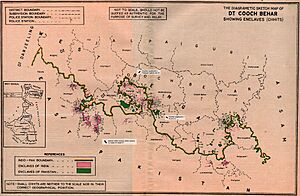
The India–Bangladesh enclaves were small pieces of land belonging to one country but located entirely inside the other. Imagine a tiny bit of India completely surrounded by Bangladesh, or a small part of Bangladesh surrounded by India! These areas were also known as Chiṭmahals.
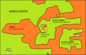
There were many of these unusual land pockets. Bangladesh had 102 Indian enclaves within its main territory. Some of these Indian enclaves even contained smaller Bangladeshi areas, called "counter-enclaves." One special place, Dahala Khagrabari, was an Indian area inside a Bangladeshi area, which was inside an Indian area, which was inside Bangladesh! It was the only "third-order" enclave in the world. India, on the other hand, had 71 Bangladeshi enclaves, some of which also contained Indian counter-enclaves.
In 2010, a count showed that about 51,549 people lived in these enclaves. Most of them (37,334) lived in Indian enclaves within Bangladesh.
To make the border simpler and help the people living in these areas, the leaders of India and Bangladesh signed an agreement in 1974. A new version of this agreement was approved on May 7, 2015. Under this new plan, India received 51 Bangladeshi enclaves, and Bangladesh received 111 Indian enclaves. People living in these areas could choose which country they wanted to belong to. The land exchange happened on July 31, 2015, and the people moved by November 30, 2015. After this exchange, India's total land area became slightly smaller.
Today, almost all these enclaves are gone. The only remaining one is Dahagram–Angarpota, which is a piece of Bangladesh located inside India.
Contents
How Did These Enclaves Start?
A fun story says that these enclaves were created centuries ago. Two kings, the Raja of Koch Bihar and the Maharaja of Rangpur, used them as stakes in card or chess games!
Historically, these unusual borders likely came from a treaty in 1713. This agreement was between the Kingdom of Koch Bihar and the Mughal Empire. It seems they ended a war without clearly drawing the lines for who owned what land. This left many small, scattered territories.
After India was divided in 1947, Rangpur became part of East Pakistan (which is now Bangladesh). Koch Bihar, with all its scattered pieces, joined India in 1949. Both countries wanted to fix these complicated borders.
In 1958, the Prime Ministers of India and Pakistan, Jawaharlal Nehru and Feroz Khan Noon, tried to exchange these areas. However, India's Supreme Court said that a special change to the country's constitution was needed to transfer land. This change faced problems, and the issue remained unsolved for a long time.
Talks started again after East Pakistan became independent as Bangladesh in 1971.
The Agreement to Exchange Land
On May 16, 1974, Prime Ministers Indira Gandhi of India and Sheikh Mujibur Rahman of Bangladesh signed the Land Boundary Agreement. This agreement planned to exchange the enclaves. India kept one area called Berubari Union No. 12. Bangladesh kept the Dahagram-Angarpota areas. India also agreed to provide a narrow path, called the Tin Bigha Corridor, so Bangladesh could reach Dahagram-Angarpota.
Bangladesh quickly approved the agreement in 1974, but India did not. There were still some small parts of the border that were not clearly marked. The Tin Bigha Corridor was finally leased to Bangladesh in 1992.
In 1997, both countries made a list of all the enclaves. They also started working together in 2001 to figure out the details. A joint count of the people living in these areas was done in 2007.
In September 2011, India signed an additional agreement. Both nations announced they would swap 162 enclaves. People living there would get to choose which country they wanted to be citizens of.
Under the final agreement, India received 51 Bangladeshi enclaves (about 7,110 acres). Bangladesh received 111 Indian enclaves (about 17,160 acres). Bangladesh kept its Dahagram-Angarpota area. After the exchange, India lost about 40 square kilometers of land to Bangladesh.
A 2010 count showed about 14,215 people in Bangladeshi enclaves in India. About 37,269 people lived in Indian enclaves in Bangladesh. All these people, who didn't really have a clear nationality, could choose their citizenship.
The Indian Parliament approved the agreement in May 2015. On June 6, 2015, Indian Prime Minister Narendra Modi and Bangladeshi Prime Minister Sheikh Hasina officially confirmed the agreement. The exchange of land and the marking of the new border happened in stages between July 31, 2015, and June 30, 2016.
Officials from both countries surveyed the enclave residents in July 2015. They found that 100 families in Indian enclaves wanted Indian citizenship. No one in Bangladeshi enclaves chose to move to Bangladesh. By August 1, 2015, nearly 14,000 people in former Bangladeshi enclaves became Indian citizens. About 36,000 people in former Indian enclaves became Bangladeshi citizens. Around 1,000 people in the former Indian enclaves chose Indian citizenship and moved to India by December 2015.
Special Enclaves
Bangladesh's Dahagram–Angarpota
Dahagram–Angarpota is the largest Bangladeshi area that was completely surrounded by India. It is part of the Lalmonirhat District in Bangladesh. This area is separated from the rest of Bangladesh by only 178 meters. It covers about 25.95 square kilometers and had about 20,000 people living there.
This area used to lack basic services. For example, its health center couldn't work because there was no electricity. India had not allowed Bangladesh to run power lines through its territory. After the 2015 land exchange, Bangladesh kept Dahagram–Angarpota as its own exclave.
The Tin Bigha Corridor is a narrow strip of Indian land, 85 meters wide. It connects Dahagram–Angarpota to the main part of Bangladesh. India leased this corridor to Bangladesh forever, so people in Dahagram–Angarpota can easily travel to their own country.
India's Dasiar Chhara and Dahala Khagrabari
Dasiar Chhara was the largest Indian enclave that stood alone. It was about 3 kilometers from the main part of India and covered 6.65 square kilometers.
Dahala Khagrabari was very unique. It was the world's only "third-order" enclave. This means it was a piece of India, inside Bangladesh, which was inside India, which was inside Bangladesh! It was a very small area, less than 0.70 hectares, and mostly contained a jute field. As part of the 2015 border agreement, India gave this special piece of land to Bangladesh.
Overview of Former Enclaves
Here's a simple way to imagine how the enclaves were set up:
|
|
Before the exchange, there were many of these tiny land pieces. Some were made up of several smaller administrative units. This made the border very confusing to manage.
 | Mary Eliza Mahoney |
 | Susie King Taylor |
 | Ida Gray |
 | Eliza Ann Grier |


