Inverie Bay facts for kids
Quick facts for kids Inverie Bay |
|
|---|---|

Inverie Bay
|
|
| Location | NM 7635 9948 |
| Coordinates | 57°01′56″N 5°41′14″W / 57.0321°N 5.68734808°W |
| Type | sea loch bay |
| River sources | Inverie river, |
| Ocean/sea sources | Atlantic Ocean |
| Islands | Inverie River. |
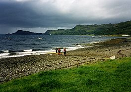
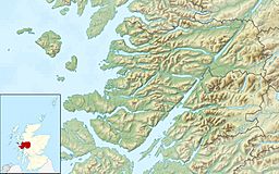
Inverie Bay is a beautiful bay on the coast of Loch Nevis. It is located in the Knoydart peninsula in Scotland. The bay is next to the small village of Inverie, which shares its name.
Inverie Bay stretches about 2.12 miles across. It faces towards the northwest part of Loch Nevis. Loch Nevis is a "sea loch," which means it's a long, narrow arm of the sea that reaches inland.
Exploring Inverie Bay
When you look out from Inverie Bay, you can clearly see Glen Meadail. This glen, or valley, is on the right side of the bay. It adds to the stunning views of the Scottish landscape.

All content from Kiddle encyclopedia articles (including the article images and facts) can be freely used under Attribution-ShareAlike license, unless stated otherwise. Cite this article:
Inverie Bay Facts for Kids. Kiddle Encyclopedia.

