Isla Apipé facts for kids

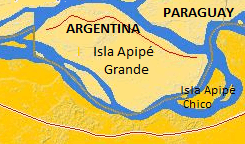
Map of island and the three others, showing approximately their greatest size when the river is low. The borders are quite clear on this map
|
|
| Geography | |
|---|---|
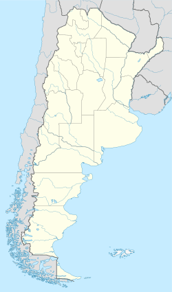
| Coordinates | 27°30′S 56°54′W / 27.500°S 56.900°W |
| Adjacent bodies of water | Paraná River |
| Administration | |
|
Argentina
|
|
| Province | Corrientes |
Isla Apipé, also known as Isla Apipé Grande, is a large island in the Paraná River. It belongs to Argentina and is about 25 kilometers (15.5 miles) long. The island is located near the Argentine city of Posadas, Misiones.
Even though it's part of Argentina, a small part of the island's border touches Paraguay. This border is often a thin strip of marshland that changes with the river's water levels.
Where is Isla Apipé?
Isla Apipé is part of the Corrientes Province in Argentina. It's separated from the rest of the province by a channel of the Paraná River. On the other side of the island is Paraguay.
Islands within a country
Isla Apipé and three other smaller islands are surrounded by Paraguay. This means they are like little pieces of Argentina completely enclosed by another country. These special areas are called exclaves and enclaves.
The other islands are:
- Isla Apipé Chico
- Isla Los Patos
- Isla San Martín
These four islands vary in size. Isla Apipé is the largest, covering about 276 square kilometers. Isla Apipé Chico is about 23.8 km², Isla Los Patos is 11.8 km², and Isla San Martín is the smallest at 3.7 km².
See also

- In Spanish: Islas Apipé para niños
 | Emma Amos |
 | Edward Mitchell Bannister |
 | Larry D. Alexander |
 | Ernie Barnes |


