
Jalilabad Rayon facts for kids
Quick facts for kids
Jalilabad (Cəlilabad)
|
|
|---|---|

Road sign at the entrance to Jalilabad Raion
|
|

Map of Azerbaijan showing Calilabad raion
|
|
| Country | Azerbaijan |
| Capital | Cəlilabad |
| Area | |
| • Total | 1,440 km2 (560 sq mi) |
| Population
(1999)
|
|
| • Total | 169,960 |
| • Density | 118.0/km2 (305.7/sq mi) |
| Postal code |
AZ1500
|
| Telephone code | 0114 |
Jalilabad (also spelled Cəlilabad) is a special area in the country of Azerbaijan. You can think of it like a district or a region. The main city and capital of this area is also called Cəlilabad.
Jalilabad is located in the southern part of Azerbaijan. It covers an area of about 1,440 square kilometers. That's roughly the size of a medium-sized city! In 1999, about 169,960 people lived in the Jalilabad region.
Location and Geography
Jalilabad is found in the southern part of Azerbaijan. It's known for its flat lands and is close to the border with Iran. The region has a climate that is good for farming. This means that many people who live here work in agriculture.
Life in Jalilabad
The main city, Cəlilabad, is the center of activity for the region. It's where people go for shopping, education, and other services. The area is connected to other parts of Azerbaijan by roads. You can see a road sign welcoming you to the region as you enter.
The people of Jalilabad are proud of their history. There is even a special place called "Martyrs' Lane" in the district. This place honors people who have given their lives for their country.
Modern Connections
Like many places today, Jalilabad is also connected to the modern world. There are telecommunication centers that help people stay in touch. These centers provide phone and internet services to the homes and businesses in the area.
Images for kids
-
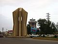
Jalilabad Center
-
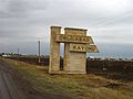
Road sign at the entrance of Jalilabad District
-
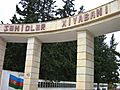
Martyrs' Lane in Jalilabad District
-

"Aztelekom" Limited Liability Company in the District


See also
 In Spanish: Raión de Yalilabad para niños
