Juchitlán facts for kids
Quick facts for kids
Juchitlán, Jalisco
|
||
|---|---|---|
|
Municipality and town
|
||
|
||

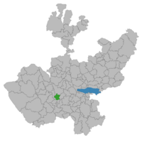
Location of the municipality in Jalisco
|
||
| Country | ||
| State | Jalisco | |
| Area | ||
| • Total | 245.9 km2 (94.9 sq mi) | |
| • Town | 1.79 km2 (0.69 sq mi) | |
| Population
(2020 census)
|
||
| • Total | 5,534 | |
| • Density | 22.505/km2 (58.288/sq mi) | |
| • Town | 3,528 | |
| • Town density | 1,971/km2 (5,105/sq mi) | |
| Time zone | UTC-6 (Central Standard Time) | |
| • Summer (DST) | UTC-5 (Central Daylight Time) | |
Juchitlán is a town and a municipality located in the state of Jalisco, Mexico. It is found in the central-western part of the country. A municipality is like a local government area that includes a main town and smaller surrounding communities.
The municipality of Juchitlán covers an area of about 245.9 square kilometers. This is roughly the size of 24,590 soccer fields!
Contents
Population and People
Juchitlán is home to thousands of people. Knowing the population helps us understand how many people live in an area.
How Many People Live Here?
According to the 2020 census, the total population of the Juchitlán municipality was 5,534 people. The main town of Juchitlán itself had about 3,528 residents. This means most people live in the town, while others live in the surrounding areas.
Where is Juchitlán?
Understanding the location helps us place Juchitlán on a map.
Geographic Location in Mexico
Juchitlán is located in the state of Jalisco, which is in central-western Mexico. Its exact coordinates are 20 degrees, 4 minutes, 59.07 seconds North and 104 degrees, 6 minutes, 0.35 seconds West. These numbers help pinpoint its spot on Earth.
Time Zone Information
Juchitlán uses the North American Central Time Zone. This means it follows Central Standard Time (CST) for most of the year, which is 6 hours behind Coordinated Universal Time (UTC-6). During Daylight Saving Time, it switches to Central Daylight Time (CDT), which is 5 hours behind UTC (UTC-5).


