Köttmannsdorf facts for kids
Quick facts for kids
Köttmannsdorf
Kotmara vas
|
||
|---|---|---|

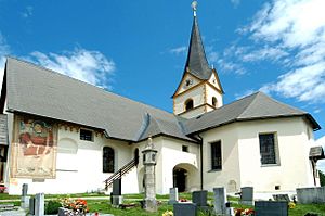
Saint George parish church
|
||
|
||
| Country | Austria | |
| State | Carinthia | |
| District | Klagenfurt-Land | |
| Area | ||
| • Total | 28.16 km2 (10.87 sq mi) | |
| Elevation | 558 m (1,831 ft) | |
| Population
(2018-01-01)
|
||
| • Total | 3,004 | |
| • Density | 106.68/km2 (276.29/sq mi) | |
| Time zone | UTC+1 (CET) | |
| • Summer (DST) | UTC+2 (CEST) | |
| Postal code |
9071
|
|
| Area code | 04220 | |
| Website | www.koettmannsdorf.at | |
Köttmannsdorf (called Kotmara vas in Slovene) is a small town in Austria. It is located in the state of Carinthia and is part of the Klagenfurt-Land district.
Where is Köttmannsdorf?
Köttmannsdorf is found southwest of the city of Klagenfurt. It sits in the higher areas of the Sattnitz Mountains. The highest point in the town is Sabalahöhe, which is 921 meters (about 3,022 feet) high. The lowest point is the Ferlach Reservoir, at 441 meters (about 1,447 feet).
A stream called the Rekabach flows through the town from west to east. Its name, reka, means "river" in the Slovene language.
Who Lives in Köttmannsdorf?
In 2001, a census showed that 6.4% of the people living in Köttmannsdorf were Carinthian Slovenes. These are people who speak the Slovene language and have a strong connection to Slovene culture.
The table below shows how many people lived in different villages within Köttmannsdorf in 1991. It also shows the percentage of people who were Carinthian Slovenes in 1991 and 1951.
| Village (German) | Village (Slovenian) | Number of people 1991 | Percent of Slovenes 1991 | Percent of Slovenes 1951 |
|---|---|---|---|---|
| Neusaß | Vesava | 48 | 45.8% | 100% |
| Plöschenberg | Plešivec | 34 | 47.1% | 81.2% |
| St.Gandolf | Šentkandolf | 77 | 6.5% | 85.4% |
| Trabesing | Trabesinje | 188 | 14.4% | 65.9% |
| Tschachoritsch | Čahorče | 251 | 16.7% | 91.7% |
| Gaisach | Čežava | 49 | 10.2% | 20.0% |
| Hollenburg | Humberk | 8 | 12.5% | 15.4% |
| St.Margarethen | Šmarjeta | 60 | 21.7% | 100% |
| Wurdach | Vrdi | 118 | 12.7% | 63.0% |
| Preliebl | Preblje | 64 | 9.4% | 46.5% |
| Göriach | Gorje | 76 | 6.6% | 28.6% |
| Tschrestal | Črezdol | 52 | 9.6% | 62.2% |
| Köttmannsdorf | Kotmara vas | 709 | 6.3% | 50.1% |
See also
 In Spanish: Köttmannsdorf para niños
 | Selma Burke |
 | Pauline Powell Burns |
 | Frederick J. Brown |
 | Robert Blackburn |


