Kandal Province facts for kids
Quick facts for kids
Kandal Province
កណ្ដាល
|
|
|---|---|

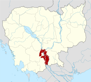
Map of Cambodia highlighting Kandal Province
|
|
| Country | |
| Provincial status | 1907 |
| Capital | Ta Khmau Municipality |
| Area | |
| • Total | 3,179 km2 (1,227 sq mi) |
| Elevation | 10 m (30 ft) |
| Population
(2019 census)
|
|
| • Total | |
| • Rank | 2nd |
| • Density | 376/km2 (970/sq mi) |
| Time zone | UTC+07 |
| ISO 3166 code | KH-8 |
| Districts | 11 |
| Communes | 146 |
| Villages | 1087 |
Kandal is a province in Cambodia. It's like a large area that completely surrounds Phnom Penh, which is the capital city of Cambodia. The main city and capital of Kandal Province is called Ta Khmau.
Geography and Rivers
Kandal Province is located in the southern part of Cambodia. It is known for its important rivers. Two of the biggest rivers in Cambodia flow through this province. These are the Bassac River and the Mekong River. These rivers are very important for travel and farming in the area.
Districts and Towns
Kandal Province is divided into different smaller areas. These areas are called districts and one municipality. A municipality is like a big town or city that governs itself.
There are 10 districts and 1 municipality in Kandal Province:
- Angk Snuol
- Kandal Stueng
- Kaoh Thum
- Khsach Kandal
- Kien Svay
- Leuk Daek
- Lvea Aem
- Mukh Kampul
- Ponhea Lueu
- S'ang
- Ta Khmau Municipality
Population and Size
According to the 2019 census, Kandal Province has a population of about 1,195,547 people. This makes it the second most populated province in Cambodia. The total area of the province is 3,179 square kilometers (about 1,227 square miles). Kandal officially became a province in 1907.
See also
 In Spanish: Provincia de Kandal para niños
 | Janet Taylor Pickett |
 | Synthia Saint James |
 | Howardena Pindell |
 | Faith Ringgold |

