Kerewan facts for kids
Quick facts for kids
Kerewan
|
|
|---|---|

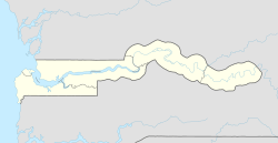
Location of the Kerewan Local Government Area
|
|
| Country | The Gambia |
| Division | North Bank Division |
Kerewan is a town in The Gambia, a country in West Africa. It is located next to a branch of the river called Miniminiyang Bolong. Kerewan is about 60 kilometers (about 37 miles) away from Banjul, which is the capital city.
This town is the main center for the Kerewan Local Government Area. This area used to be known as the North Bank Division. Kerewan is found on the northern side of the lower part of the Gambia River.
In 2013, a count of the population showed that over 225,000 people lived in the Kerewan Local Government Area. About 3,500 of these people lived right in Kerewan town itself.
Most people in the Kerewan Local Government Area work in agriculture. This means they grow crops. Their main crops include groundnuts, rice, maize (corn), and millet.
Climate in Kerewan
Kerewan has a tropical climate. This means it's generally warm all year round. The weather changes between a dry season and a rainy season.
Temperature Changes
The hottest months in Kerewan are usually April and May, when temperatures can reach around 39 degrees Celsius (about 102 degrees Fahrenheit). The coolest months are December and January, but it's still warm, with highs around 34 degrees Celsius (about 93 degrees Fahrenheit).
Rainfall Patterns
Most of the rain in Kerewan falls during the summer months. July, August, and September are the wettest. August gets the most rain, with nearly 300 millimeters (about 12 inches). From November to April, there is very little to no rain.
| Climate data for Kerewan (1991–2020) | |||||||||||||
|---|---|---|---|---|---|---|---|---|---|---|---|---|---|
| Month | Jan | Feb | Mar | Apr | May | Jun | Jul | Aug | Sep | Oct | Nov | Dec | Year |
| Mean daily maximum °C (°F) | 34.4 (93.9) |
36.5 (97.7) |
38.5 (101.3) |
39.1 (102.4) |
38.1 (100.6) |
35.9 (96.6) |
33.0 (91.4) |
— | 32.2 (90.0) |
33.9 (93.0) |
35.4 (95.7) |
34.7 (94.5) |
— |
| Daily mean °C (°F) | 25.0 (77.0) |
26.3 (79.3) |
28.2 (82.8) |
29.0 (84.2) |
29.2 (84.6) |
29.1 (84.4) |
27.9 (82.2) |
— | 27.4 (81.3) |
28.3 (82.9) |
27.5 (81.5) |
25.9 (78.6) |
— |
| Mean daily minimum °C (°F) | 15.6 (60.1) |
16.5 (61.7) |
18.1 (64.6) |
19.0 (66.2) |
20.3 (68.5) |
22.5 (72.5) |
22.6 (72.7) |
22.8 (73.0) |
22.6 (72.7) |
22.7 (72.9) |
19.5 (67.1) |
16.9 (62.4) |
19.9 (67.8) |
| Average precipitation mm (inches) | 0.5 (0.02) |
0.8 (0.03) |
0.0 (0.0) |
0.0 (0.0) |
2.2 (0.09) |
77.7 (3.06) |
197.1 (7.76) |
295.0 (11.61) |
226.8 (8.93) |
74.5 (2.93) |
0.0 (0.0) |
0.1 (0.00) |
874.7 (34.44) |
| Average precipitation days (≥ 1.0 mm) | 0.1 | 0.2 | 0.0 | 0.0 | 0.2 | 3.9 | 11.7 | 16.0 | 14.2 | 4.7 | 0.0 | 0.0 | 51.0 |
| Source: NOAA | |||||||||||||


