
Kip Water, Inverclyde facts for kids
Quick facts for kids Kip Water |
|
|---|---|

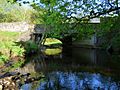
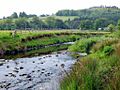
Kip Water at Bridgend
|
|
| Country | Scotland |
| Counties | Inverclyde |
| Physical characteristics | |
| Main source | Compensation Reservoir in Inverclyde Cornalees Bridge, Inverclyde, Scotland, United Kingdom 178 m (584 ft) 55°54′34.0″N 4°48′21.0″W / 55.909444°N 4.805833°W |
| River mouth | Inverkip, Inverclyde, Scotland, United Kingdom 55°54′29.8″N 4°52′37.7″W / 55.908278°N 4.877139°W |
| Length | 7 km (4.3 mi) |
| Discharge (location 2) |
|
The Kip Water, also known as the River Kip, is a short river in Inverclyde, Scotland. The village of Inverkip gets its name from this river, as "Inverkip" means "mouth of the River Kip." The river begins at Cornalees in the hills between Inverkip and Greenock. It flows through Shielhill Glen, Dunrod Glen, and the Kip Valley. Finally, it enters the Firth of Clyde at Kip Marina in Inverkip.
Contents
The Story of Kip Water
Maps from the early 1800s show that the Kip Water used to have different names. John Ainslie's map from 1800 called the upper part "Shaws Burn." The lower part was known as "Ardgowan Water." This was before a big project called the Shaws Water Scheme was built in 1827. This project changed where the river started.
Later, in 1832, John Thomson's map still called the upper part "Shaws Burn." But the lower part was called "Ardgowan or Kipp Water." It is not clear exactly when the name "Kip Water" was used for the entire river.
Where Kip Water Flows Today
Today, the Kip Water starts at the Compensation Reservoir near Cornalees Bridge. From there, it flows steeply down Shielhill Glen to Millhouse. At Millhouse, it passes under a bridge often called the 'Roman Bridge.'
The river then enters Dunrod Glen. Here, it flows around three sides of Idzholm Hill. The Spango Burn joins the Kip Water in this area. After this, the river enters the Kip Valley. The last part of the river, from Bankfoot Farm to the Clyde, is quite flat. People have added several small weirs (small dams) to this section over the years.
Past Activities Along the River
Old maps from the 1800s show that there were mills near what is now Ardgowan Policies. These included a waulkmill, which was used for making cloth. Today, there are almost no signs left of these old mills. It is also likely there was another mill further upstream at Millhouse, based on the name of the house.
In the late 1800s, three sandstone quarries were busy at the top of Shielhill Glen. A railway line was built to serve these quarries. This railway left the main line at Dunrod Farm. You can still clearly see the path of this old railway line along most of its route.
Current Activities Along the River
As of May 2018, there is not much industry along the Kip Water. The main businesses are the workshops located at Kip Marina.
Future Plans for the River
Plans have been approved to build a distillery at Bankfoot Farm. This will be the Ardgowan Distillery. The distillery plans to use water from the Kip Water for its processes and for cooling. It will also use water from some nearby springs. As of May 2018, no opening date for the distillery has been set.
Bridges Over Kip Water
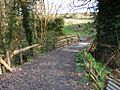
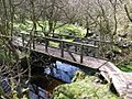
Many bridges cross the Kip Water. The highest one upstream is Cornalees Bridge. This bridge crosses a waterfall where the river leaves Compensation Reservoir. It is a modern bridge made of concrete and steel, built in the late 1900s. It carries a small road over the river. A little further downstream, there is a wooden footbridge. This bridge is part of the Cornalees nature trail.
You can find traces of an old bridge near the disused sandstone quarries at the top of Shielhill Glen. Slightly downstream, you can see the stone supports of a former railway bridge at Majeston Farm. This bridge had three spans and carried a short railway line from Dunrod to the quarries in the late 1800s. A wooden farm bridge also crosses the river at this spot.
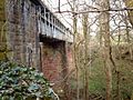
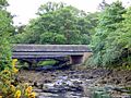
Millhouse Road crosses the river on a stone arched bridge. From this bridge, you can see the impressive single arch of the 'Roman Bridge' on the private grounds of Millhouse. Just downstream from Millhouse, a railway viaduct made of sandstone and steel carries the train line from Glasgow to Wemyss Bay. Next to this viaduct, you can see the supports of a second viaduct that was removed in the late 1960s.
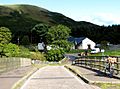
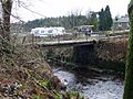
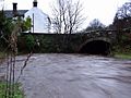
A steel and timber bridge crosses the river at Bankfoot Farm. You can also see the remains of another small bridge between Bankfoot and Bridgend. At Bridgend, there are two bridges side-by-side. One of them is no longer used. It was replaced when the A78 road was changed in the early 1970s. Between this bridge and Kip Marina, there is a broken-down farm track bridge. This bridge leads from Ardgowan Policies to Swallow Brae plantation.
At Kip Marina, there are two more bridges next to each other. One of them is now only for walking and used to serve Ardgowan House. A new concrete bridge replaced it in 2006 when Kip Marina Village was built. The very last bridge is a floating pontoon bridge within Kip Marina itself.
Bridges Gallery
- Kip Water Bridges Photo Gallery - From Source To Sea
-
The furthest upstream bridge, at Compensation Reservoir
-
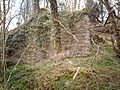
Remains of railway bridge in Shielhill Glen
-
The dilapidated wooden bridge near Majeston Farm
-
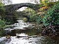
'Roman Bridge' and Millhouse Road bridge at Millhouse
-
Dunrod Glen railway viaduct
-
Bankfoot Farm bridge
-
The stone supports of a former bridge, one on each bank, downstream from Bankfoot.
-
Disused bridge at Bridgend
-
View upstream to the A78 road bridge at the north end of Inverkip
-
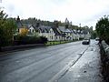
Bridgend Cottages and the A78 road bridge over Kip Water
-

Old bridge to Ardgowan House, now a footbridge
-
Old and new bridges at Kip Marina
-
The river is tidal at this point. The old bridge to Ardgowan can also be seen.
-
The furthest downstream bridge on the river


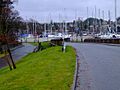
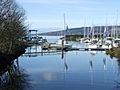
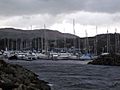
Kip Marina

Kip Marina is located where the Kip Water meets the Firth of Clyde. It is named after the river. This marina was the first of its kind in Scotland. It opened in 1971 with 250 places for boats. At that time, it was one of only three marinas in the whole UK! Since then, it has grown a lot. In 2018, it had over 600 places for boats.
Kip Marina Village

Kip Marina Village is a housing area built in the 2000s. It is right next to the marina. The houses are built around three sides of the marina. This means most homes have great views of the boats. Some houses also have clear views of the Firth of Clyde. Kip Marina Village is considered part of Inverkip. However, it is separated from the main village by the busy A78 Main Road. A special footbridge helps people walk from the center of Inverkip to the marina and Kip Marina Village.
Gallery
- Kip Water Photo Gallery - From Source To Sea
-
The source of Kip Water at Compensation Reservoir
-
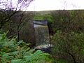
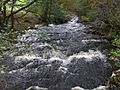
Kip Water waterfall at Compensation Reservoir outflow
-
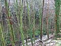
Kip Water near the top of Shielhill Glen
-
Kip Water in Shielhill Glen
-
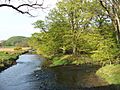
Kip Water upstream from the bridge at Millhouse
-
'Roman Bridge' crossing Kip Water at Millhouse
-
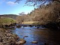
Kip Water in Dunrod Glen
-
Kip Water at Bankfoot Farm
-
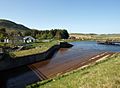
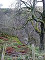
Land erosion just downstream of Bankfoot, which can be seen in the background
-
A weir on Kip Water just above Bridgend
-
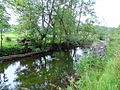
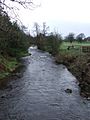
Kip Water. Daff Water joins on the right
-
Kip Water entering Kip Marina
-
Kip Water enters the Clyde at this point


