Kurdamir Rayon facts for kids
Quick facts for kids
Kurdamir
|
|
|---|---|

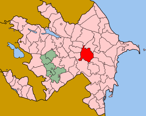
Map of Azerbaijan showing Kurdamir Raion
|
|
| Country | Azerbaijan |
| Capital | Kürdəmir |
| Area | |
| • Total | 1,631 km2 (630 sq mi) |
| Population
(2011)
|
|
| • Total | 106,128 |
| • Density | 65.069/km2 (168.53/sq mi) |
| Telephone code | 0145 |
Kurdamir (also spelled Kürdəmir) is a special kind of administrative area, called a raion, in the country of Azerbaijan. Think of a raion like a county or a district in other parts of the world. The main town and capital of this district is also called Kürdəmir.
What is a Raion?
A raion is a type of region used for local government. It helps to organize the country into smaller, easier-to-manage parts. Each raion has its own local leaders and services. This system helps to make sure that people living in different areas get the support they need.
Where is Kurdamir Located?
Kurdamir Raion is found in the country of Azerbaijan. Azerbaijan is located in the South Caucasus region, at the crossroads of Eastern Europe and Western Asia. The district is situated in the central part of Azerbaijan. You can see its location on the map provided in the infobox above. Its coordinates are about 40.34 degrees North latitude and 48.16 degrees East longitude.
People and Area in Kurdamir
As of 2011, about 106,128 people lived in the Kurdamir Raion. This makes it a moderately populated area. The total size of the Kurdamir district is about 1,631 square kilometers (which is about 630 square miles). This area is roughly the size of a large city or a small state. The people living here contribute to the local economy and culture of Azerbaijan.
See also
 In Spanish: Raión de Kurdamir para niños
 | Valerie Thomas |
 | Frederick McKinley Jones |
 | George Edward Alcorn Jr. |
 | Thomas Mensah |

