
Las Trampas Regional Wilderness facts for kids
Quick facts for kids Las Trampas Regional Wilderness |
|
|---|---|

Panoramic view near the junction of Rocky Ridge and Sycamore trails
|
|
| Type | Regional Wilderness park |
| Location | Alameda and Contra Costa Counties, California |
| Nearest city | Danville, California |
| Area | 5,342-acre (21.62 km2) |
| Operated by | East Bay Regional Park District |
Las Trampas Regional Wilderness is a huge park covering about 5,342 acres (21.6 square kilometers) in Northern California. It's located in Alameda and Contra Costa counties, close to the city of Danville. The name Las Trampas means "the traps" or "the snares" in Spanish. This amazing outdoor area is managed by the East Bay Regional Park District (EBRPD).
Contents
Exploring Las Trampas Regional Wilderness
Las Trampas Regional Wilderness is known for its rugged beauty. It has two long, hilly ridges: Las Trampas Ridge on the east and Rocky Ridge on the west. Between these ridges is a narrow valley where Bollinger Creek flows. You'll find a horse stable and visitor parking here.
Challenging Trails and Great Views
Some of the hiking trails in the park are quite steep. They can go up or down as much as 900 feet (274 meters)! Because of these tough climbs, the park is sometimes called "the tough guy" of the East Bay Regional Park District. It's a great place for a challenging adventure.
Plants and Rocks You Might See
The southern and western slopes of the ridges are covered with many types of plants. You'll see black sage, chamise, and buck brush. There are also toyon, manzanitas, elderberry, and many other species. Some of the rocks in the park have layers of ancient fossils!
Rocky Ridge reaches a height of 2,024 feet (617 meters). From a trail at 1,760 feet (536 meters), you can connect to other areas. These trails can lead to the Valle Vista Staging Area or south to the Chabot staging area.
The Chamise and Bollinger Creek Loop trails lead to Las Trampas Ridge. From this ridge, you can enjoy amazing views. You'll see the Ygnacio, San Ramon, and Amador valleys. You can also spot Mount Diablo and the Carquinez Straits in the distance.
Picnic Spots for Everyone
Near the parking lot, there are two picnic areas called Steelhead and Shady. These spots are available first-come, first-served. If you have a large group (50 to 300 people), you can reserve picnic sites at the nearby Little Hills Picnic Ranch.
Trails and Wildlife in the Park

Las Trampas offers trails for everyone! Bicycles are allowed on about half of the trails. Equestrians (people riding horses) and hikers can use all the trails. Dogs are also welcome to join you on your adventure.
Meeting the Park's Animals
You might see cows, calves, and steers grazing on the trails. Sometimes, you might even spot a free-ranging bull. These cattle help keep the grass short, which is important for fire safety in the summer. Remember to keep a safe distance from them, as they can be protective.
The park is home to many wild animals. You could spot deer, raccoons, rattlesnakes, and skunks. Look up to see hawks, vultures, and sometimes even an eagle flying overhead. Coyotes and bobcats are also common. While mountain lion sightings are very rare, their tracks have been seen. It's always a good idea to be careful with small dogs and children, especially after sunset, because of wild animals.
Trees of Las Trampas
The most common trees in the park are California bay laurel and coast live oak. You might also find buckeye, big leaf maple, canyon live oak, and black oak. Scrub oak, which often has mistletoe, seems to grow best on the ridgetops at the end of Chamise Trail.
Special Areas and Waterfalls
On its eastern side, the park completely surrounds the Eugene O'Neill National Historic Site. You can reach this historic site from Las Trampas using hiking trails. You can also get there by a single-lane road from Danville. The eastern part of the park also has several hidden waterfalls. Most of these are a bit tricky to reach.
A part of Las Trampas on the western slope is a sensitive watershed for the East Bay Municipal Utility District (EBMUD). This means it's a special area that helps collect and protect water. Because of this, visitors need a valid EBMUD permit to hike in this specific area.
Gallery
-
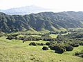
View east from Rocky Ridge toward Las Trampas Ridge. The visitor parking lot is among the trees at the bottom of the valley. Mount Diablo is in the hazy distance.
-
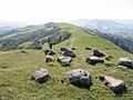
View looking south along Rocky Ridge trail.
-
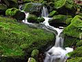
A small cascade in the Las Trampas Regional Wilderness.
-
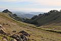
The EBMUD watershed, looking west toward San Francisco from Rocky Ridge.


See also
 In Spanish: Yermo Regional Las Trampas para niños
