
Leylands, Leeds facts for kids


The Leylands was a historic area in the city of Leeds, England. It was located just north of the city centre and west of a place called Mabgate. Long ago, in 1775, a map by John Cossins showed two fields named 'Ley Lands' in this spot. By 1881, the area was fully built up and known as 'The Leylands'. In 1887, over 6,200 people lived there. Some streets in the area, like Trafalgar Street and Nile Street, were named around 1815 to celebrate famous naval victories by Horatio Nelson.
Contents
Where Was The Leylands?
The Leylands was located between Vicar Lane and North Street on its western side. To the east, it was bordered by Eastgate and Regent Street. Lady Lane formed its southern edge, and Skinner Lane was its northern boundary. The main road through the area was Bridge Street. This street got its name from Lady Bridge, which crossed the Lady Beck. The beck itself was the eastern border of The Leylands.
Life in The Leylands
The Leylands was known for having many houses built close together. Most of these homes were built before 1847 and were for workers in the nearby factories and mills. These factories started appearing in the 1800s. In 1889, the area was described as a "dank district," meaning it was often damp and not very inviting.
However, there were efforts to make things better. For example, a new school was built in 1875 by the Leeds School Board. This school aimed to provide education for the children living in the area. The local church, St Luke's, was built in 1841. It stood on the corner of Skinner Lane and North Street, but it has since been taken down.
A Home for New Communities
Because the rents were low, The Leylands attracted many new people, including immigrants from Ireland. By the mid-1890s, a large part of the area became home to the Jewish community. In 1892, out of 1,300 houses, about 900 were lived in by Jewish families.
A synagogue, which is a Jewish place of worship, was built in The Leylands. The school that was built in 1875 eventually became a Jewish school. There were also three other Jewish schools in the area. By 1901, this small area, less than 50 acres in size, was home to more than 6,000 Jewish people.
Tailoring and Work
Many Jewish people in The Leylands worked in tailoring, which is making clothes. The workshops in the area, sometimes called "sweatshops," became well-known. A "sweatshop" is a place where people work long hours for low pay in poor conditions. The 1901 Census showed that tailoring was the main job for over 2,200 Jewish men and 850 Jewish women. This was far more than any other job.
Just north of Skinner Lane, there is still a building that belonged to the "Tailors' Machinists & Pressers' Trade Union." This was a special trade union for Jewish workers. A trade union is a group that helps workers get fair pay and good conditions. This building was also used for social events for the Jewish community.
A famous clothing maker named Montague Burton came to The Leylands. He built a clothing factory on Concord Street. He wanted to create a business with good working conditions. This factory was very successful and later led to a much larger factory being built in Harehills.
Changes Over Time
As the Jewish community became more successful, many families and their businesses moved north to an area called Chapeltown. Because of this, and as part of a plan to clear older, crowded areas, much of The Leylands was redeveloped in 1936 and 1937.
Some buildings from the 1800s still remain. One is the Smithfield Hotel on North Street, built around 1860. It was originally built to serve the cattle market across the road. Later, it became the front office for an ironworks called Thomas Green & Son. This company made many things, from lawnmowers to steamrollers.
Another important building is the Lyons Works on Templar Lane, built in 1914. This factory was one of the first to use a production line, which makes manufacturing faster. More recently, it has been used as a background for art projects by the Leeds College of Art.
The Leylands Today
Today, much of The Leylands area is used for public car parks for the city centre. However, you can also find some offices, apartments, and light industry there. The area is home to the Leeds College of Building and buildings used by The Salvation Army for worship and community activities.
Images for kids
-
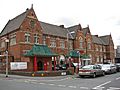
Leylands School Building from 1875
-
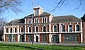
The Smithfield Hotel, which was also part of an ironworks
-
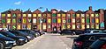
The Lyons Works building and a car park
-
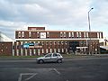
The Leeds College of Building


More Images
-
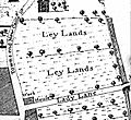
A map detail showing 'Ley Lands' from 1726

