Lime Kilns (Lincoln, Rhode Island) facts for kids
Quick facts for kids |
|
|
Lime Kilns
|
|

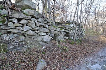
Lime kiln remains off Sherman Avenue
|
|
| Lua error in Module:Location_map at line 420: attempt to index field 'wikibase' (a nil value). | |
| Location | Lincoln, Rhode Island |
|---|---|
| Built | 1750 |
| MPS | Lincoln MRA |
| NRHP reference No. | 84002015 |
| Added to NRHP | August 30, 1984 |
The Lime Kilns in Lincoln, Rhode Island, are very old stone structures. They are what's left of three special ovens called lime kilns. These kilns were part of one of the first places in North America to process lime. People have been working with lime in this area since the 1600s!
These historic kilns are found in different spots around Lincoln. You can find them near Louisquisset Pike, Sherman Avenue, and Dexter Rock Road. When they were first built, they looked like big stone cylinders. They were made from rocks stacked together without mortar.
Contents
What is a Lime Kiln?
Making Lime from Limestone
A lime kiln is like a giant oven used to heat limestone. Limestone is a type of rock. When you heat limestone to very high temperatures, it changes into something called "lime." This process is known as calcination.
Why Was Lime Important?
Lime was super important in the past. People used it for many things. It was a key ingredient in mortar, which is like the glue that holds bricks and stones together in buildings. Lime was also used to improve farm soil and even to make plaster for walls.
The Historic Lime Kilns of Lincoln
The Oldest Lime Operations
The area around Lincoln, Rhode Island, has a long history with lime. People discovered that the local rocks were perfect for making lime. This led to many lime processing businesses starting up here. The kilns you see today are a reminder of this important industry.
Exploring the Three Kilns
There are three main kiln ruins that are still visible today. Each one tells a part of the story of early American industry.
The Largest Kiln
The first kiln is the biggest of the three. Its ruins are located near the Flanagan campus of the Community College of Rhode Island. This kiln was about 20 feet (6 meters) wide. Imagine how much lime it could make! You can find its remains west of Louisquisset Pike.
The Sherman Avenue Kiln
The second kiln is south of Sherman Avenue. It's close to where Sherman Avenue meets Louisquisset Pike. In 1984, the walls of this kiln were still about 8 feet (2.4 meters) high. You could also see three openings in its structure.
The Dexter Rock Road Kiln
The third kiln is on the south side of Dexter Rock Road. Not much of this kiln is left. Only a part of one wall is still standing. Even so, it's a valuable piece of history.
Why These Kilns Are Special
These lime kilns are more than just old ruins. They are a link to America's past. They show us how people lived and worked hundreds of years ago. Because of their historical importance, the Lincoln Lime Kilns were added to the National Register of Historic Places in 1984. This means they are protected and recognized as important historical sites.
 | Madam C. J. Walker |
 | Janet Emerson Bashen |
 | Annie Turnbo Malone |
 | Maggie L. Walker |

