
List of Indiana state historical markers in Orange County facts for kids
Welcome to Orange County, Indiana! Did you know that historical markers are like outdoor history books? They are special signs placed in important spots to tell us about the past. These markers help us learn about events, people, or places that shaped our state. In Orange County, Indiana, there are three official state historical markers. They were put there by the Indiana Historical Bureau to share amazing stories from long ago.

Contents
Discovering History: Indiana's Markers in Orange County
These special markers in Orange County teach us about early settlement and important moments in history. Each one has a unique story to tell!
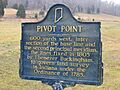
The Pivot Point Marker
The Pivot Point marker was placed in 1961. You can find it where State Road 37 meets Pivot Point Road. This is about 6.5 miles south of Paoli. This marker tells us about the early days of settlement and exploration in the area. It reminds us of the first people who came to live and explore this part of Indiana.
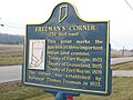
Freeman's Corner Marker
The Freeman's Corner marker was put up in 1966. It is located on the eastern side of State Road 37, just north of Orleans. This marker is important because it talks about early settlement and exploration. It also highlights the history of American Indian and Native American people in this region. It helps us remember the original inhabitants of the land.
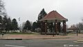
Orleans Congress Square Marker
The Orleans Congress Square marker is the newest of the three, placed in 2004. You can find it on the eastern side of Congress Square in Orleans, along Veterans Way Street. This marker celebrates the historic district of Orleans. It tells us about the town's neighborhoods and how it was settled. It's a great way to learn about the history of Orleans itself.
Images for kids
-
The Pivot Point historical marker
-
The Freeman's Corner historical marker
-
The Orleans Congress Square historical marker


See also
- List of Indiana state historical markers
- National Register of Historic Places listings in Orange County, Indiana
