
List of Indiana state historical markers in Porter County facts for kids

Have you ever seen a special sign that tells you about an important place or event? These are called historical markers! They are like outdoor history books, helping us learn about the past right where things happened. Porter County, Indiana, has five of these cool markers. They were put up by the Indiana Historical Bureau to remember important moments and people in the county's history. Let's explore what these markers tell us!
Contents
Historical Markers in Porter County
The Iron Brigade Marker
The first historical marker in Porter County is about the Iron Brigade. This marker was placed in 1995 in Chesterton, along U.S. Route 20. The Iron Brigade was a very famous group of soldiers during the American Civil War. They were known for being incredibly brave and tough fighters. Even though they were from states like Indiana, Wisconsin, and Michigan, they fought many important battles. This marker helps us remember their courage and their part in American history.
Willow Creek Confrontation Marker
Also placed in 1995, the Willow Creek Confrontation marker is located in Portage, at Woodland Park. This marker tells a story about transportation, business, and labor in the area. It likely highlights a significant event related to the growth of industries or how people worked and traveled in Porter County. Historical markers often show us how communities developed and changed over time, especially with new roads, railways, or factories.
Ogden Dunes Ski Jump Marker
In 1997, a marker for the Ogden Dunes Ski Jump was placed in Ogden Dunes, at Kratz Field. This one is all about sports and special events! Imagine people skiing and jumping right here in Indiana. This marker reminds us of unique sports activities and fun events that took place in the past. It shows that Porter County has a history of exciting outdoor activities and community gatherings.
Edwin Way Teale Marker
The Edwin Way Teale marker was put up in 2009 in Chesterton, on U.S. Route 20. Edwin Way Teale was a very important person who loved nature. He was a famous writer and photographer who taught many people about the natural world around them. This marker celebrates his work in education, his love for nature, and his contributions to newspapers and media. It reminds us to appreciate the environment and the people who help us understand it better.
Legacy of Steel / Burns Harbor Steel Plant Marker
The newest marker in Porter County, placed in 2018, is about the Legacy of Steel / Burns Harbor Steel Plant. You can find it at the Burns Harbor Town Hall. This marker focuses on business, industry, and labor. It tells the story of the huge steel plant in Burns Harbor, which has been a very important part of the local economy and provided many jobs for people in the area. It shows how big industries have shaped the lives and communities in Porter County.
Images for kids
-
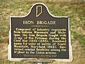
The Iron Brigade historical marker.
-
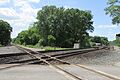
The Willow Creek Confrontation historical marker.
-
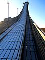
The Ogden Dunes Ski Jump historical marker.
-

The Edwin Way Teale historical marker.


