
List of Indiana state historical markers in Vigo County facts for kids

Vigo County, Indiana, is home to many special historical markers. These markers are like outdoor signs that tell us about important people, places, and events from the past. They help us learn about history right where it happened!
The Indiana Historical Bureau places these markers. They make sure we remember the cool stories and facts about Indiana's history. Vigo County has 15 of these markers. Each one shares a unique piece of the past. Let's explore some of them!
Famous People Remembered
Many important people lived in Vigo County. Some of them have historical markers dedicated to their lives and achievements.
Paul Dresser: The Songwriter
Paul Dresser was a famous American songwriter. He was born in Terre Haute in 1859. He wrote many popular songs, including "On the Banks of the Wabash, Far Away." This song became Indiana's state song! There are two markers about him. One is at Fairbanks Park, and another is a block away.

Chauncey Rose: The Builder
Chauncey Rose was a very important person in Terre Haute. He lived from 1794 to 1877. He helped build many things in the city. He also helped start the Terre Haute Rose Polytechnic Institute. This school is now called Rose-Hulman Institute of Technology. It is a famous engineering college.

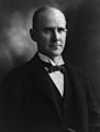
Eugene V. Debs: The Voice for Workers
Eugene V. Debs (1855-1926) was a well-known political leader. He fought for the rights of working people. He believed that everyone should be treated fairly. Debs ran for president of the United States several times. His home in Terre Haute is now a museum. It helps people learn about his life and ideas.

Charles Gene Abrell: A War Hero
Charles Gene Abrell was a brave soldier from Vigo County. He was born in 1931. He served in the military and was honored for his courage. His marker is near the Wabash River. It reminds us of his sacrifice.

Saint Theodora Guérin: A Woman of Faith and Education
Saint Theodora Guérin (1798-1856) was a French nun. She came to Indiana in 1840. She founded the Sisters of Providence of Saint Mary-of-the-Woods. This was the first women's religious community in Indiana. She also started Saint Mary-of-the-Woods College. It is one of the oldest Catholic colleges for women in the United States. She was made a saint in 2006.
Evangeline E. Harris: An Educator's Legacy
Evangeline E. Harris was an important African American educator. She worked at Indiana State University. Her marker celebrates her contributions to education and her community. She helped many students learn and grow.
Important Places and Events
Vigo County also has markers for places and events that shaped its history.
Birthplace of the Coca-Cola Bottle
Did you know the famous Coca-Cola bottle was designed in Terre Haute? In 1915, the Root Glass Company created its unique shape. This design made the bottle easy to recognize, even in the dark! This marker celebrates this cool invention.

Union Hospital: A Place of Healing
Union Hospital has been serving the community for a long time. It opened in Terre Haute in 1892. The hospital has helped countless people get better over the years. Its marker tells the story of its important role in local healthcare.
Crossroads of America
Terre Haute is sometimes called the "Crossroads of America." This is because important roads and railways met here. Wabash Avenue was a key part of the National Road. This road helped people travel and trade across the country. The marker shows how important Terre Haute was for transportation.

Markle Mill Site: A Busy Place
The Markle Mill was an important mill in the area. Mills were places where grain was ground into flour. This was a vital service for early settlers. The marker tells about the mill's history and its role in the community.

Wea Tribe at Terre Haute
Long before settlers arrived, the Wea Tribe lived in this area. They were Native Americans who had their homes and villages here. The marker at Fairbanks Park helps us remember their history and their connection to the land.
Diverse Communities
Vigo County has been home to many different groups of people. Their stories are also told through historical markers.
Little Syria on the Wabash
In the early 1900s, many Syrian immigrants came to Terre Haute. They created a vibrant community known as "Little Syria." They built churches and businesses. This marker celebrates their culture and contributions to the city.

Hungarian Community
Terre Haute also has a strong Hungarian community. Many Hungarian immigrants settled here and built new lives. Their marker celebrates their heritage and the impact they had on the city's growth.
Images for kids
-
Eugene V. Debs, a champion for workers' rights.

See also
- List of Indiana state historical markers
- National Register of Historic Places listings in Vigo County, Indiana
